The Minnesota North Shore is a stunning area along Lake Superior known for its many hiking trails, beaches, small towns and all-around beauty. The North Shore is typically said to describe the 150-mile stretch of land along Lake Superior, located between Duluth and the border of Canada.
In both Duluth and the rest of the North Shore region, there are all types of hiking trails. Whether you’re searching for the best waterfalls along the North Shore or the best scenic views, this list has you covered. Keep reading to learn about 11 epic trails along the MN North Shore and in Duluth.
Things To Know Before Hiking on the Minnesota North Shore
- The trail descriptions are based upon summer conditions. In the winter, this region gets a lot of ice and snow, so these trails would require different preparations and considerations.
- The mosquitoes can be AWFUL in this area during the summer months. Make sure to pack your insect repellent! They tend to be the worst in the morning and dissipate a bit throughout the day as it gets hotter.
- Bears and moose live on the North Shore. Be sure to properly store your food while camping and never approach or feed wildlife.
- Please remember to leave no trace while you’re out exploring. That includes packing out your trash, staying on the trails, never carving on rocks or trees, and respecting those around you.
New to hiking? Check out my beginner's hiking guide!
The Best Waterfall Trails on the MN North Shore
Caribou Falls
- 1.2 miles
- 190 ft of elevation gain
- Rated easy
- Free
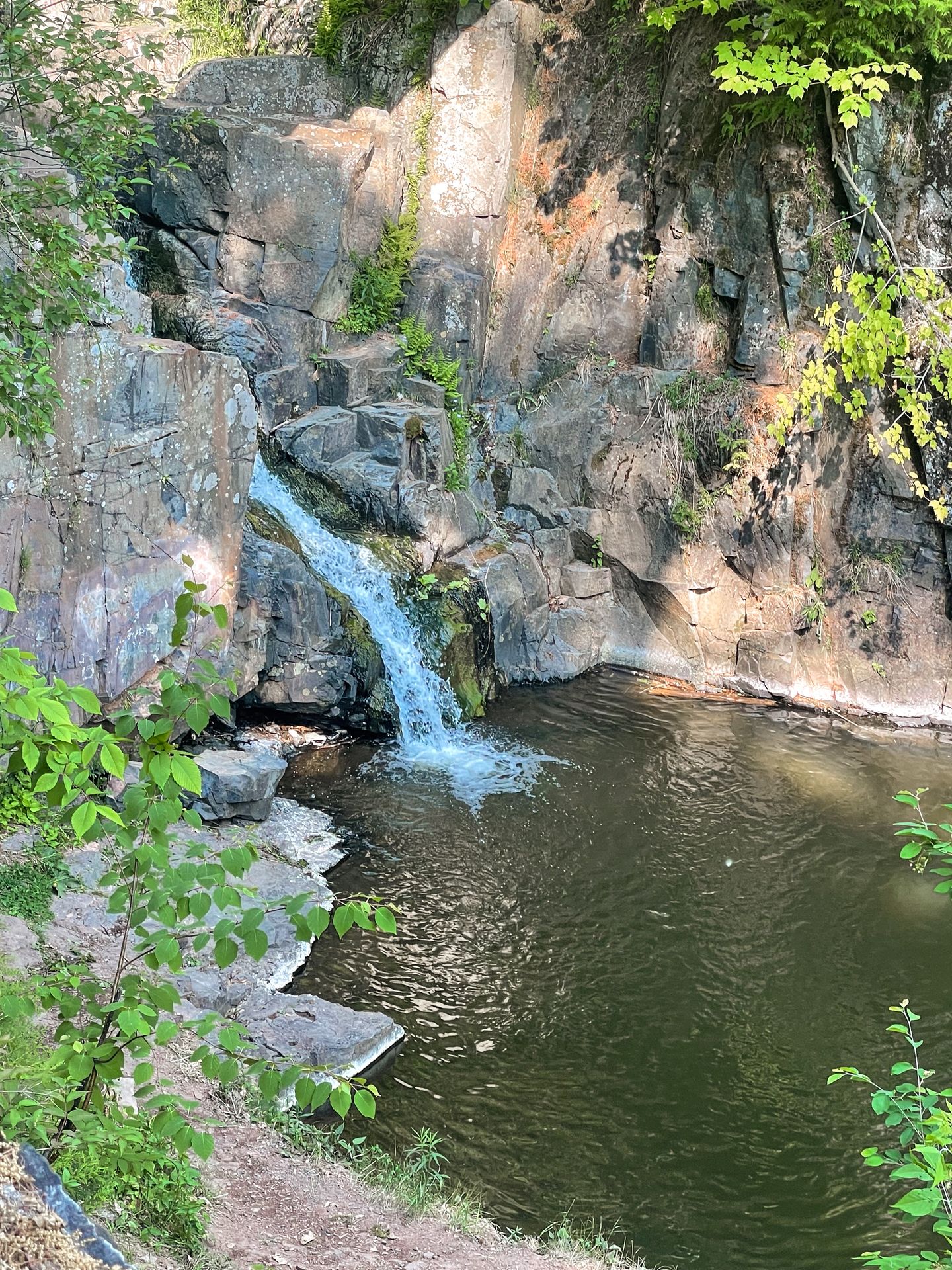
I’m not sure if it was the lack of crowds or the waterfall itself, but Caribou Falls ended up being my favorite waterfall on the Minnesota North Shore!
This easy trail is free to visit and will lead you along a peaceful river before you reach the waterfall itself. When you come to Caribou Falls, you’ll take some steps down to the water and be able to see it face to face.
The water level may vary based on time of year and recent rainfall, but typically you can wade a bit at the bottom to get a closer look. The falls flow down a reddish rock wall and are especially beautiful during golden hour.
If you’re looking for a quick waterfall trail to add to your North Shore itinerary, make sure to include Caribou Falls!
High Falls, Grand Portage State Park
- 1.1 miles
- 65 ft of elevation gain
- Rated easy
- Free
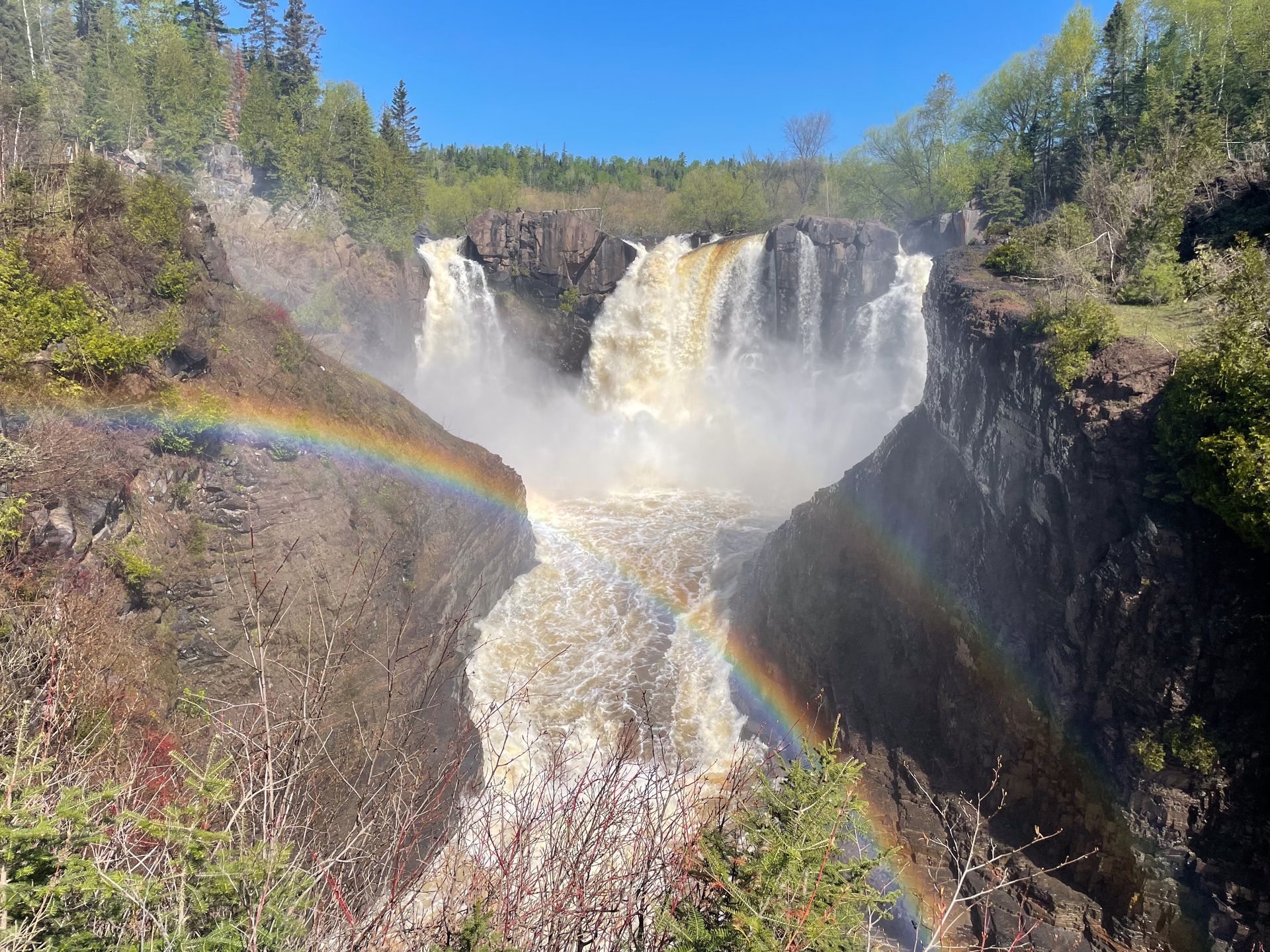
High Falls is right on the border of Canada and is epic to behold. In fact, it’s the tallest waterfall in Minnesota at 120-feet high. Plus, the walk to reach it is quick and relatively easy.
You will park at the Grand Portage Visitor Center, which doubles as a rest area. It’s actually the last place to stop off before you reach the USA-Canada border crossing. There are free restrooms and parking.
From there, you’ll follow a paved path to reach the waterfall. It’s about a half-mile walk with a slight incline. When you get close, you’ll need to climb up a series of steps to see the falls. There are two separate viewpoints to enjoy it from various angles.
The waterfall is truly stunning. Water flows down into a rocky gorge at multiple points, and it’s quite common to see a rainbow reflected in the air in front of the falls. It packs a lot of punch for the amount of effort involved.
High Falls is quite popular for good reason. I recommend going early to beat the crowds.
Gooseberry Falls to Fifth Falls
- 3 miles
- 298 ft of elevation gain
- Rated easy
- Free to park at visitor center
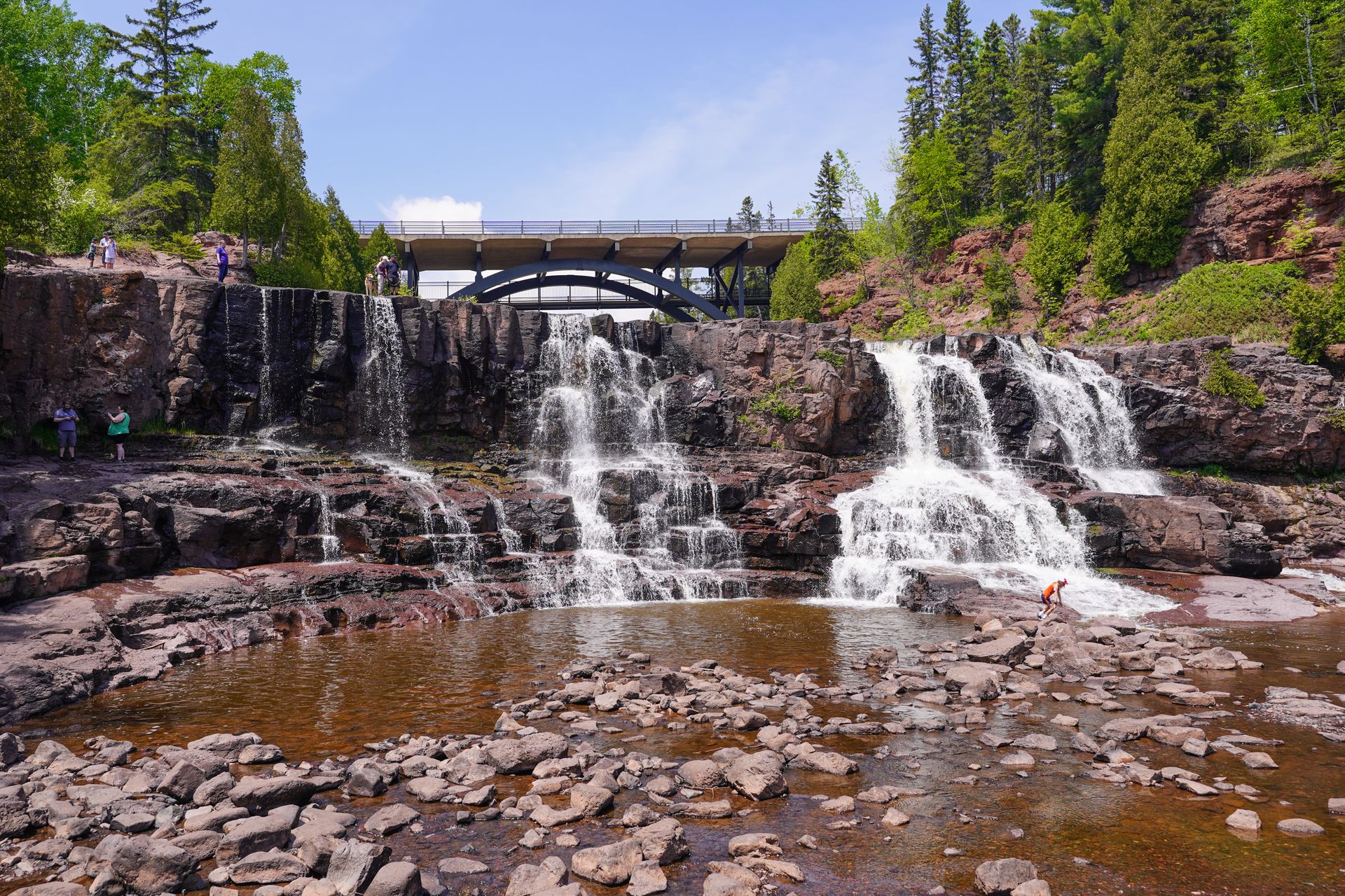
Gooseberry Falls State Park is a stunning park on the North Shore that offers multiple large and impressive waterfalls. Similar to Grand Portage, this park doubles as a rest stop along the North Shore Scenic Drive.
There are 3 waterfalls very close to the parking area - Lower Falls, Middle Falls and Upper Falls. In my opinion, Middle Falls is the most impressive due to its size. You can reach Lower Falls by taking the steps down from Middle Falls, and you can catch a view of the Upper Falls by crossing under the MN 61 road.
You are able to get quite close to the Lower Falls and Middle Falls. You’ll see people wading in front of them and climbing all over the river area. These falls also get quite crowded during peak times.
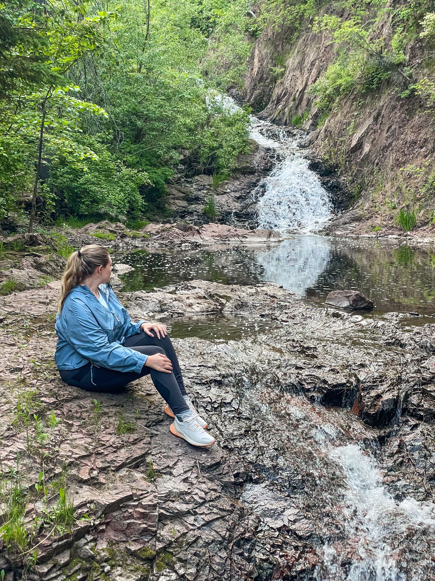
If you want to escape the crowds, take the hike to Fifth Falls. The trail is easy with little elevation change and comes in at 3 miles round trip. It’s a peaceful hike that follows along the Gooseberry River. When you reach Fifth Falls, it’s hard to see it at first. You’ll want to cross over to the Northeast side of the river and climb down a bit to get a good view.
Gooseberry Falls is a must-see during your Minnesota North Shore trip, and the hike to Fifth Falls makes for a great add-on.
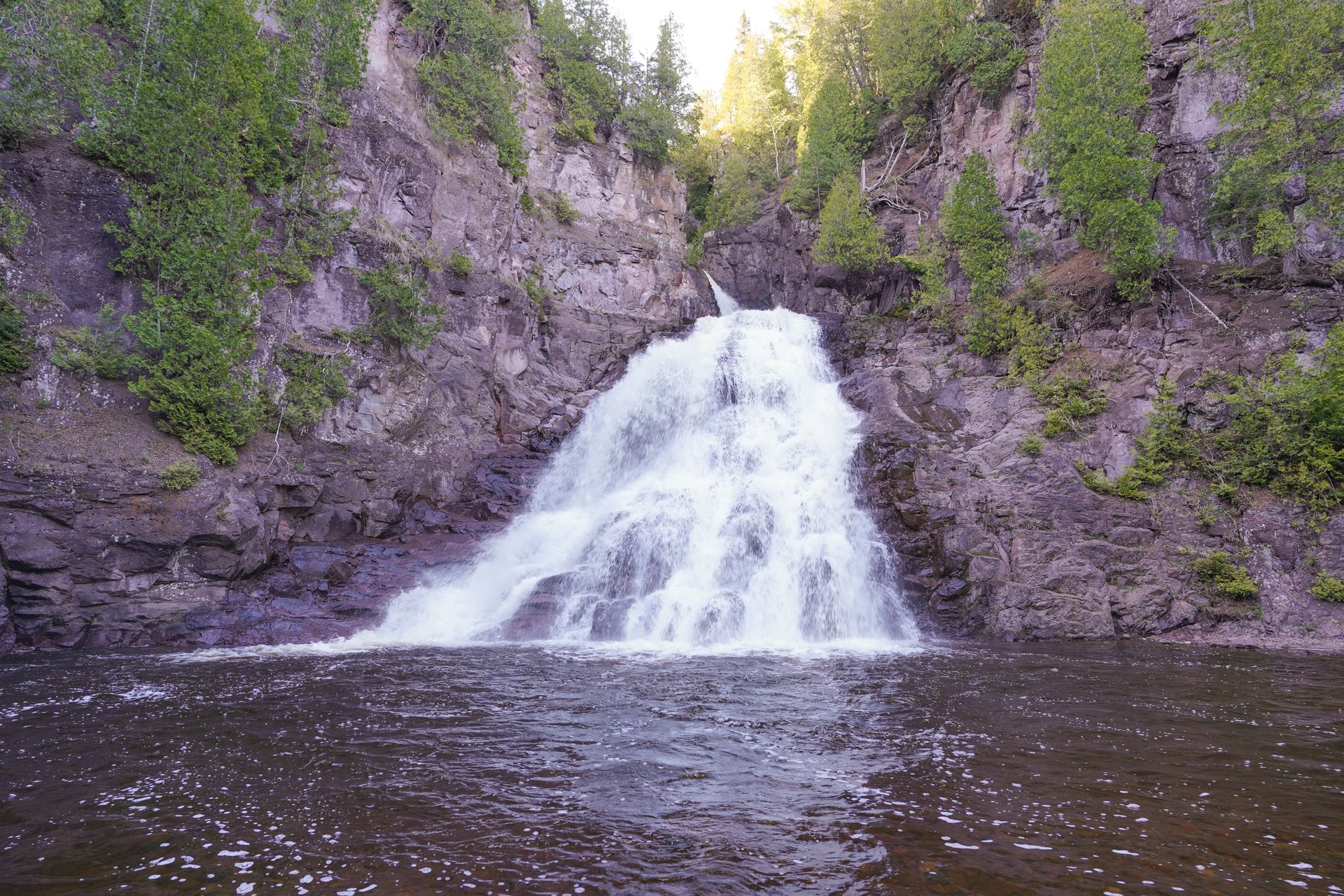
Devil’s Kettle
- 2 miles
- 393 ft of elevation gain
- Rated moderate
- $7 day fee
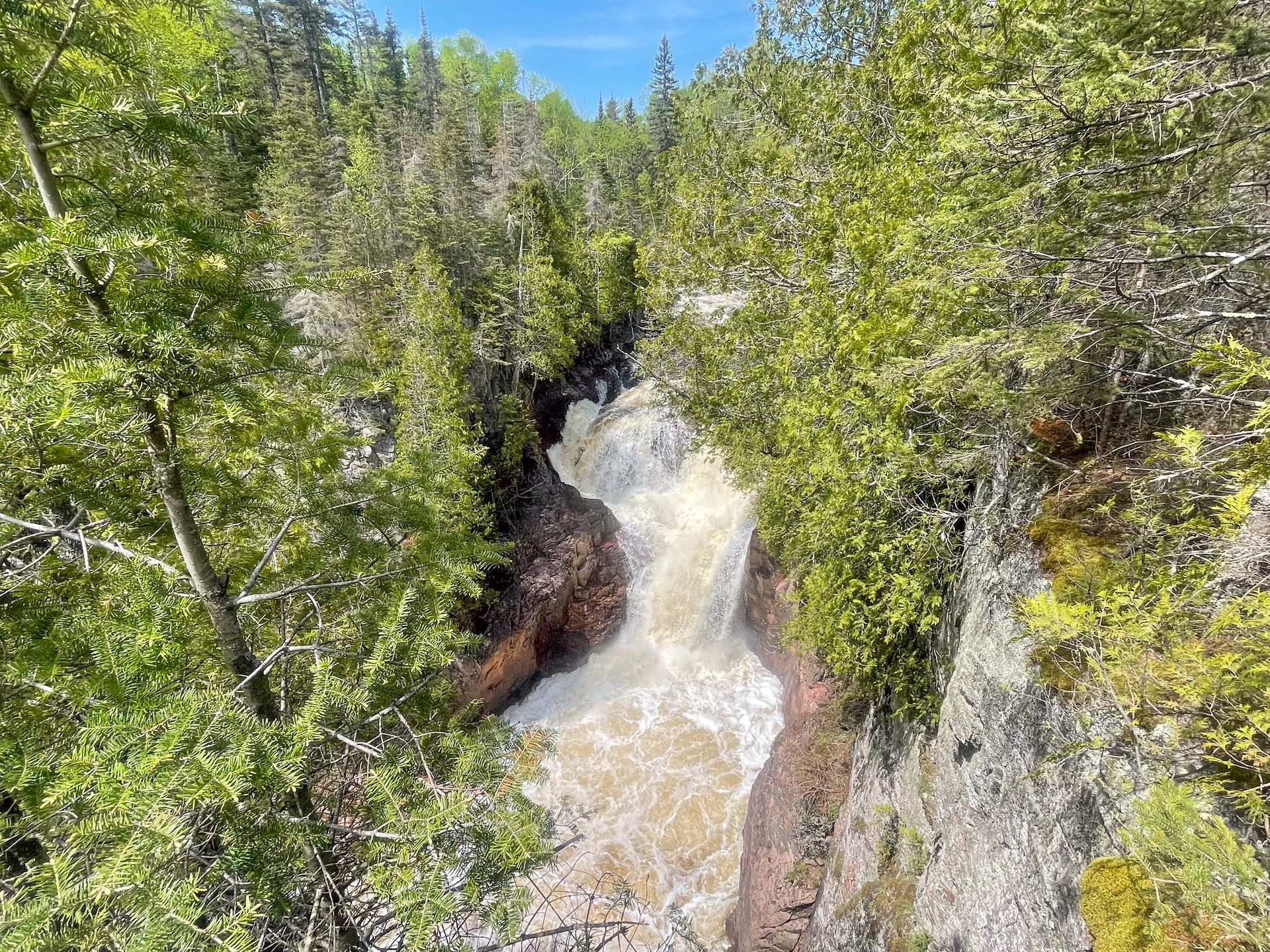
Devil’s Kettle is another iconic waterfall along the Minnesota North Shore. The waterfall is famous for it’s mysterious geology. There are two side-by-side waterfalls, and one seemingly disappears into a hole in the rocks. The other creates a whirlpool, which is also quite unique and fascinating. While the water looks like it disappears, scientists say that it reenters the river from underground.
This trail is located in Judge C.R. Magney State Park and it’s easiest to pay the fee online ahead of time when you visit. You can only pay using your phone from the trailhead, and we had very limited celluar service.
The trail follows along the Brule River. It begins with a gradual uphill climb, and then you’ll ascend down 177 steps to reach the Upper Falls, another waterfall ahead of Devil’s Kettle. During my visit, the viewing area of Upper Falls was washed out from storm damage, so it was a bit hard to see.
You will then climb back up more steps to see Devil’s Kettle. There are a couple different viewpoints to see the waterfall from above. Just keep in mind that you’ll need to climb up many steps to return back to the parking lot.
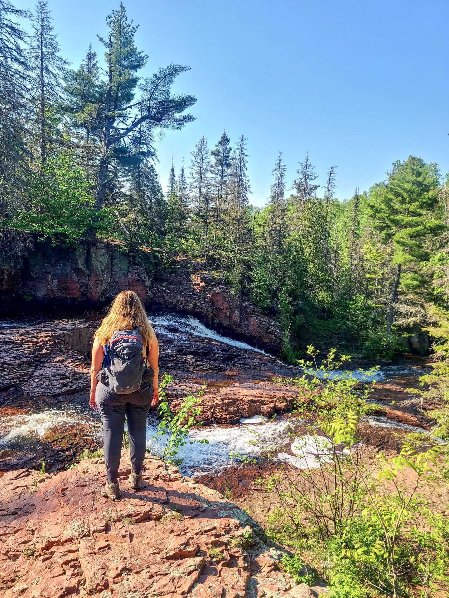
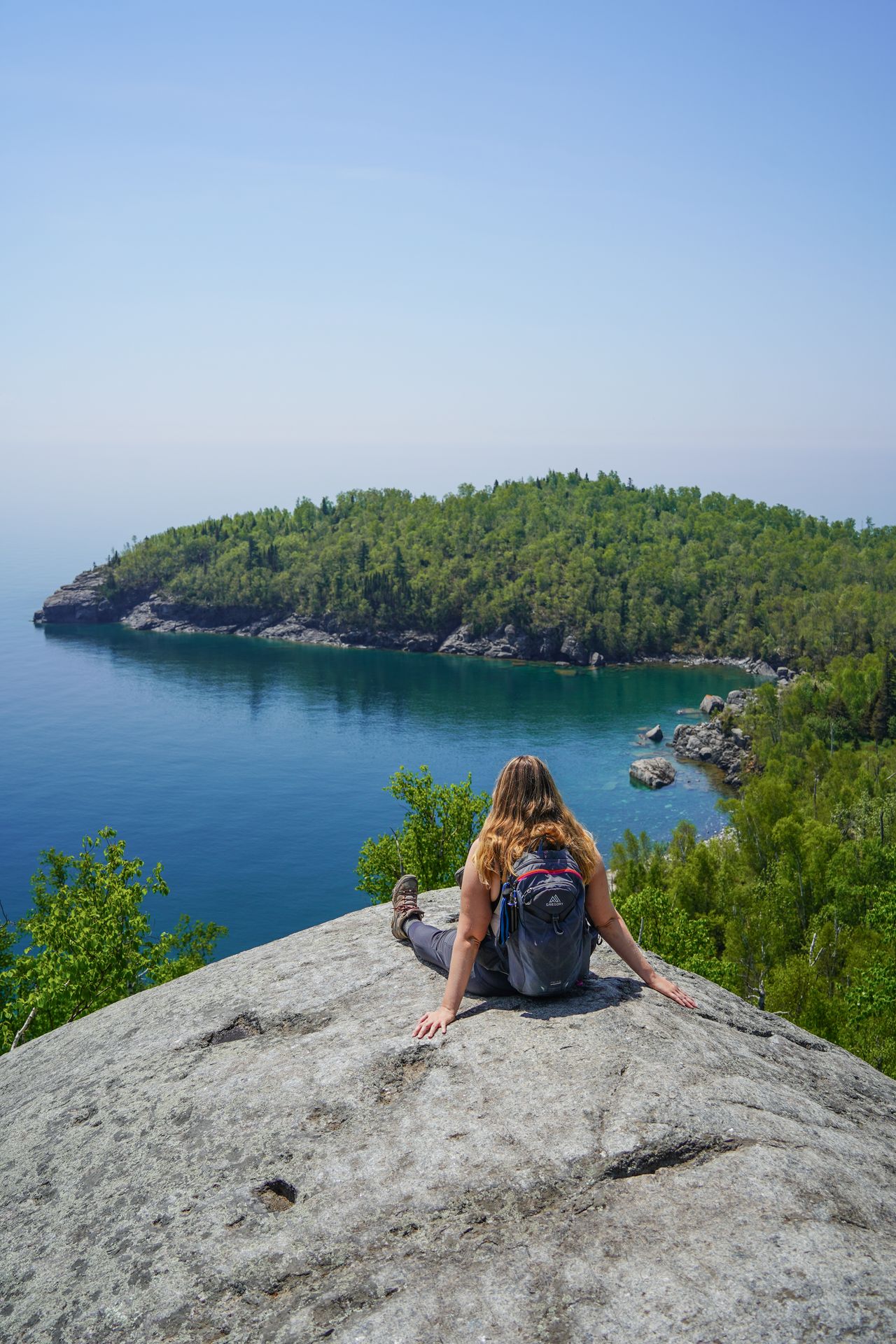
Split Rock Ridge
- 5.6 miles
- 656 ft of elevation gain
- Rated moderate
- Free
The east side of the Split Rock River Loop will close on September 1, 2024 for trail repair. Check for updates on SuperiorHiking.org.
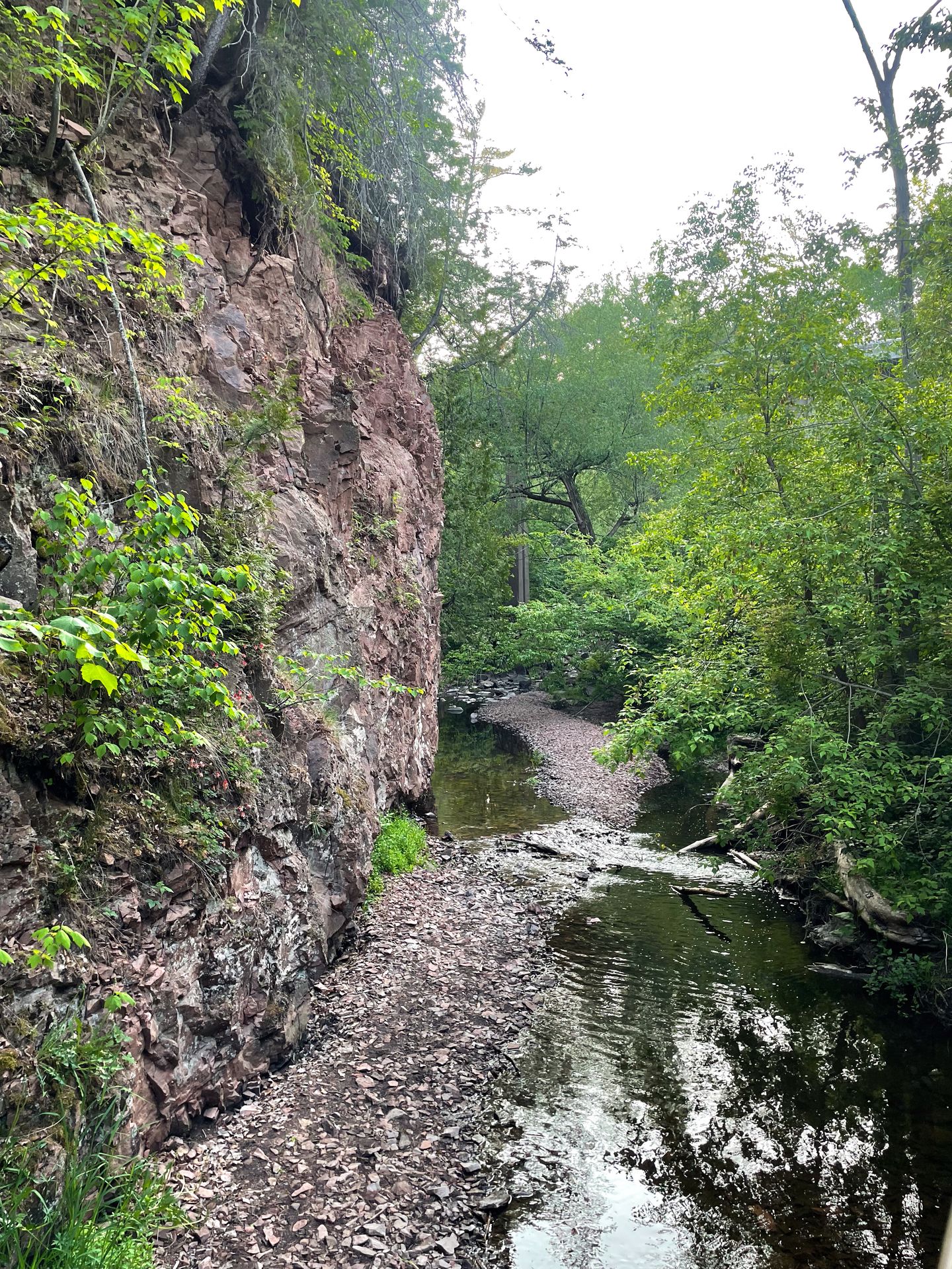
The Split Rock Ridge hike is a great option if you’re looking for a quieter trail with a nice variety of terrain. Starting at a Wayside along the Minnesota North Shore Scenic Drive, you’ll spend the first half of the hike along the water. There are nice views of the Split Rock River with multiple waterfalls along the way.
Keep in mind that you can hear more waterfalls than you can actually see, as some are not very visible from the trail.
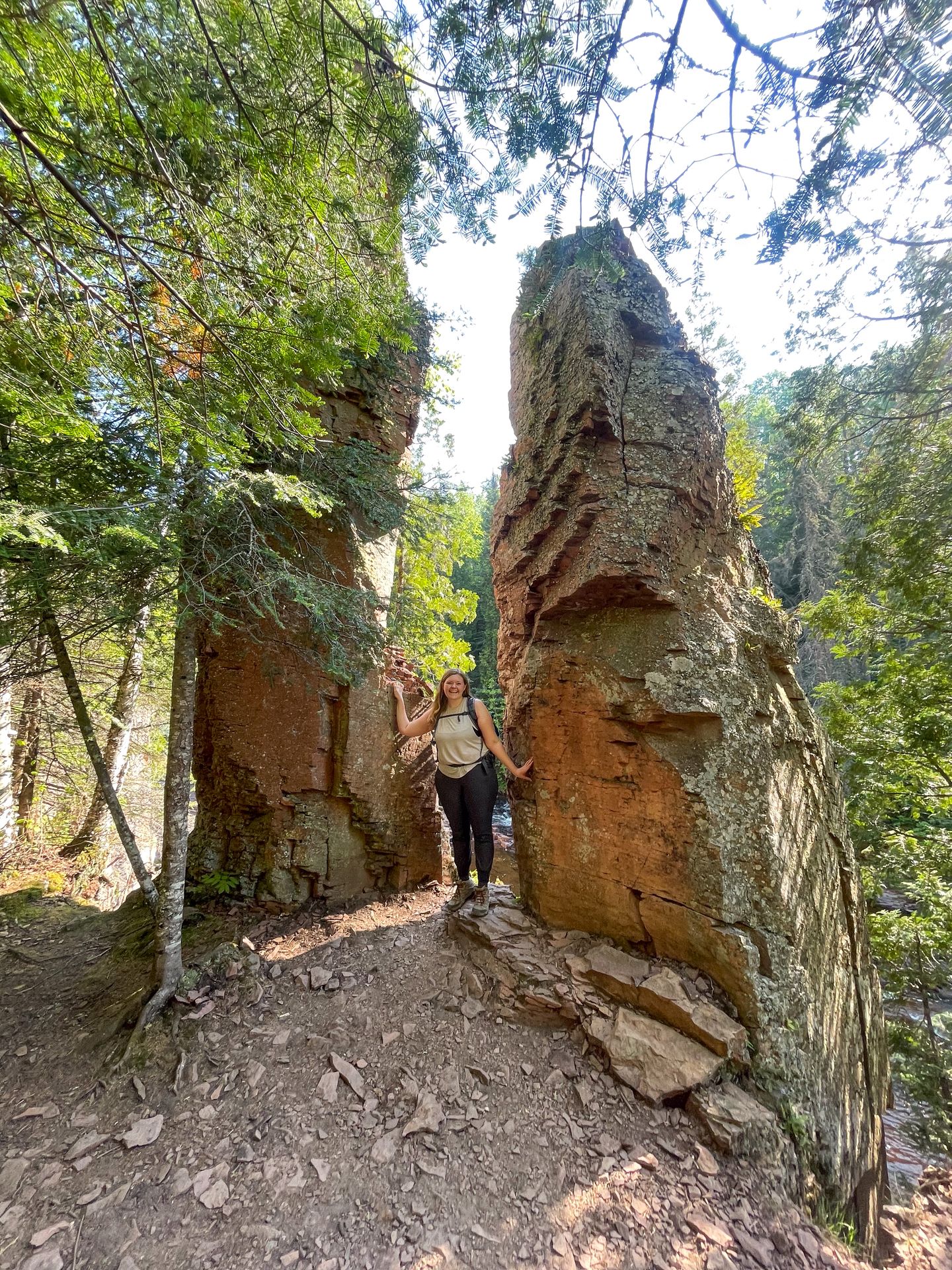
One main highlight of the hike is seeing the “split rock” itself. There are two towering rock formations that seem to have been split in half. It’s located on the opposite side of the river from the Southeast campsite.
During my visit, the bridge that typically connects you between the two sides of the river was completely out due to storm damage. However, there were a few areas ahead of the bridge where you could cross the river on rocks. This river crossing may be a bit tricky depending on your comfort level.
The trail on the opposite side follows the river for a bit, but soon it separates from the water and ascends up a hill. This unexpected part of the trail has views of Lake Superior and is quite the change of pace. This part of the hike is also hot, as there is very little shade.
Finally, you’ll climb back down the hill and cross the road to complete the loop via a short, paved section of Gitchi Gami State Trail. If you’d like, you can also head down to the beach area along Lake Superior where the Split Rock River enters the lake. This unique hike is full of variety and will likely be a lot less crowded than other trails in the area.
Chester Park Loop, Duluth
- 2.4 miles
- 351 ft of elevation gain
- Rated easy
- Free
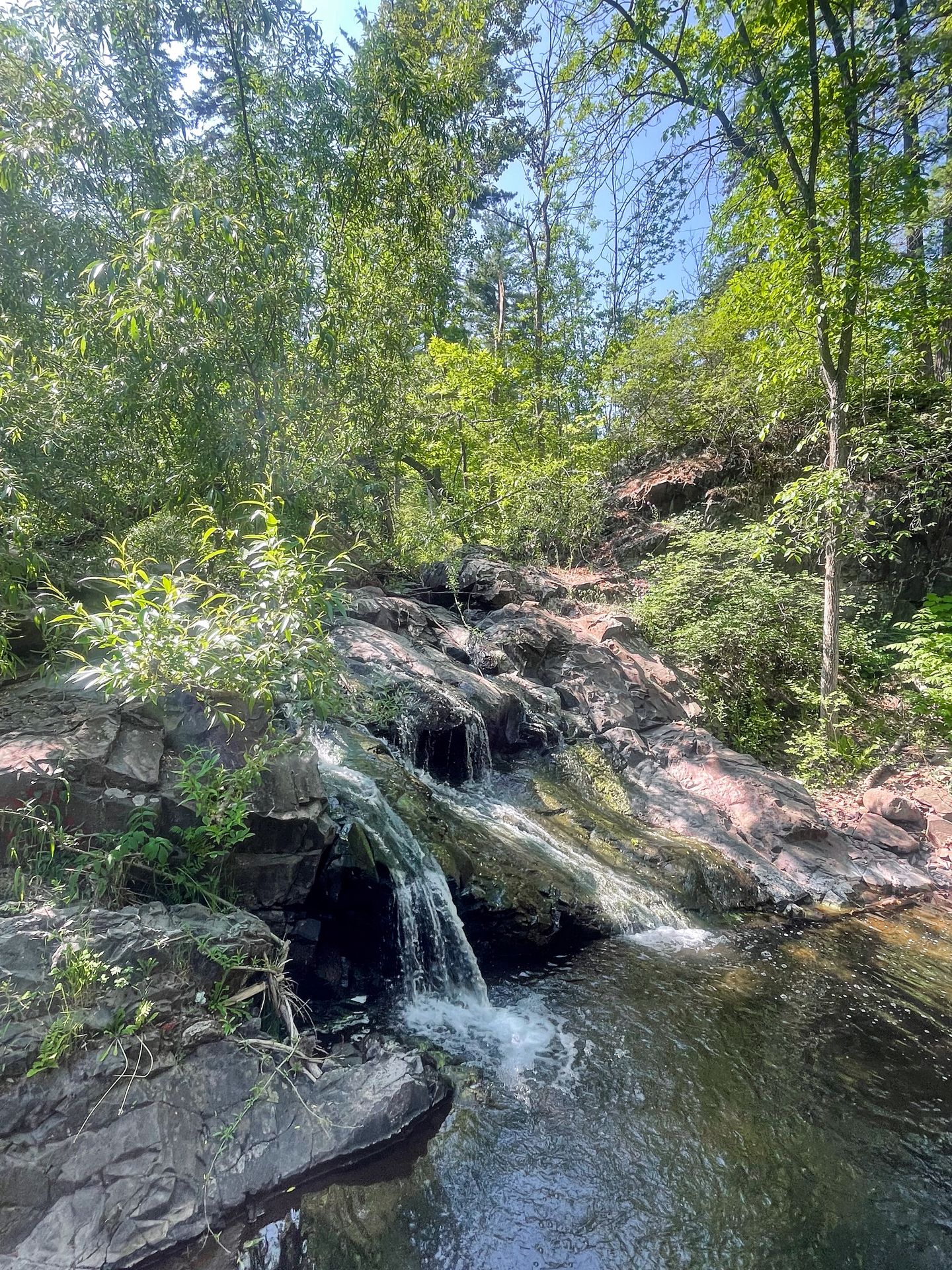
This trail is packed with waterfalls and centrally located in the heart of Duluth. The trail begins right by the Chester Bowl Improvement Club, which offers skiing, snowboarding, camp programs for kids, and more.
The hiking trail follows along both sides of Chester Creek. There are several areas along both sides where you can get right up to the water. You will see multiple small waterfalls along the way. While the trail may be busy with locals exercising, it’s easy to find a peaceful river oasis and have it all to yourself.
This hidden gem in Duluth is a lovely place to stretch your legs and explore during a trip to Duluth.
Congdon Park, Duluth
- 1.2 miles
- 226 ft of elevation gain
- Rated easy
- Free
Congdon Park is another local spot in a Duluth neighborhood that includes a beautiful waterfall. You can park on the street and find the steps that will lead you down into the gorge.
At the bottom, you’ll find some tall waterfalls along a winding path. There are bridges crossing back and forth over the water and to each side of the gorge. It’s a gorgeous and peaceful area for a quick hike.
The Best Hikes for Scenic Views on the MN North Shore
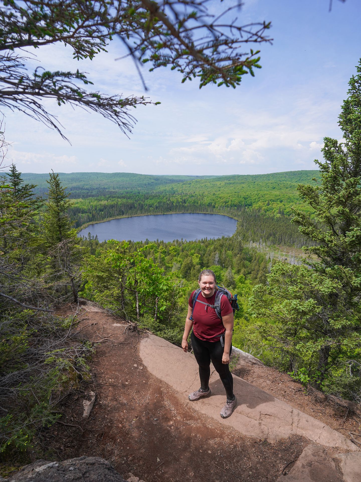
Bean and Bear Lake
- 6.9 miles
- 1118 ft of elevation gain
- Rated hard
- Free
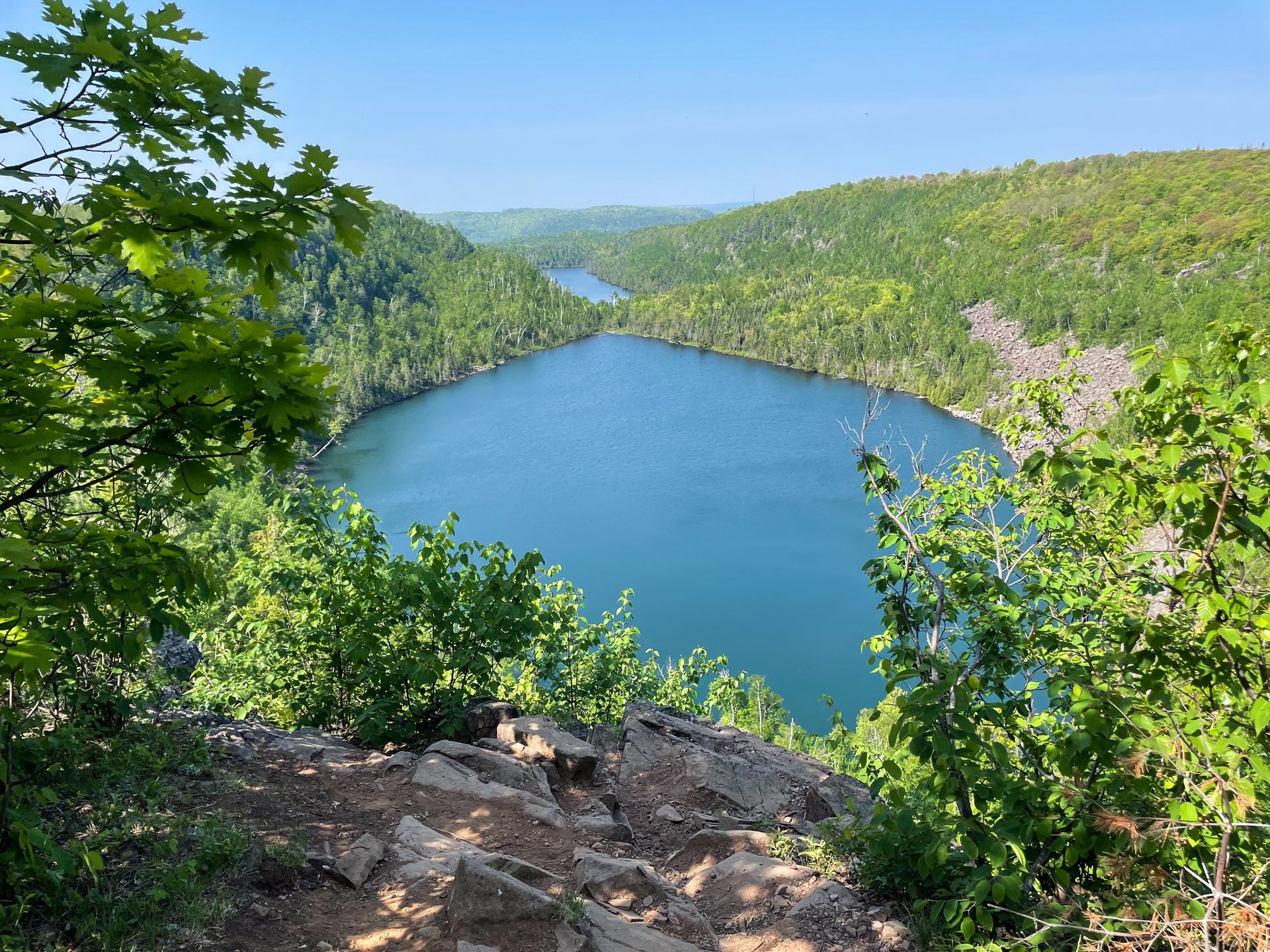
The Bean and Bear Lake Trail will close on May 15th, 2024 for trail repair. It is unclear how long it will be closed. Check for updates on [https://superiorhiking.org/].
The hike to Bean and Bear Lake is an iconic North Shore trail! In fact, this is arguably the most beautiful hike in Minnesota. This trail will lead you up on cliffs that provide epic views of two separate lakes that seem to “kiss” in the middle. Plus, you’ll hike through some forested sections and views of the surrounding area.
It is free to park and take this hike, but keep in mind that there is no restroom at the trailhead.
The trail starts through a partially forested path where you’ll pass a couple of water towers. The entire trail has several ups and downs and a good amount of elevation, making it a great workout.
As you approach the lakes, the trail becomes a loop. We hiked next to the lakes first and looped back around through the wooded section.
The trails along the lakes are easily the highlight of the hike. You’ll get to enjoy so many fantastic views of the water from several different angles. My favorite view is around the halfway point, where you’ll get to look directly out and see both lakes at once.
During my visit in June, the trail was muddy in some areas, and the mosquitoes were pesky. Make sure you bring your insect repellant!
If you’re looking for a bit of a longer trail to enjoy on the North Shore, I can’t recommend this one enough.
Mt Josephine
- 2.5 miles
- 649 ft of elevation gain
- Rated moderate
- Free
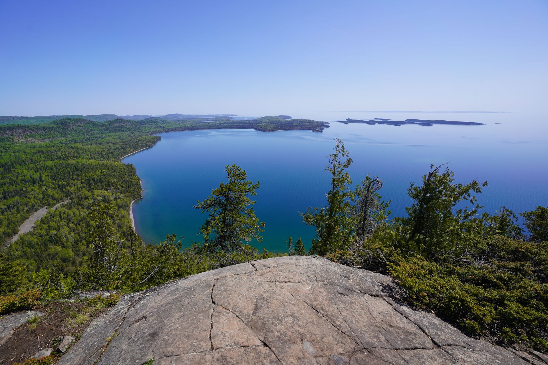
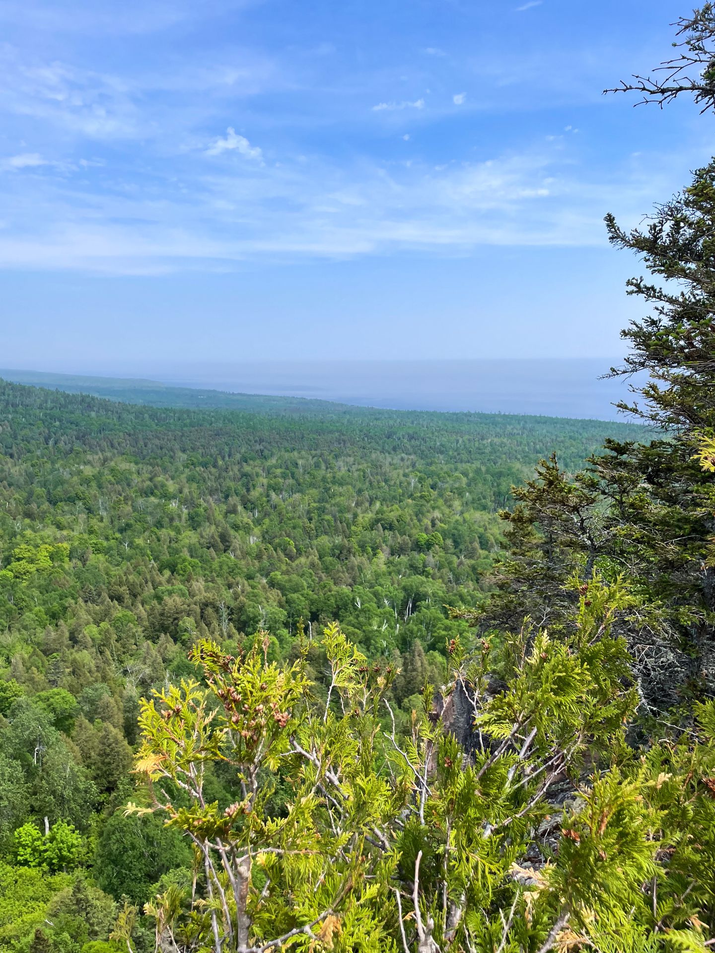
The hike to Mt Josephine is one that is underrated and worth the effort. A 2.5 mile trek will lead you to a fantastic viewpoint gazing down at Lake Superior, the Wauswaugoning Bay and some small islands scattered along the shore.
You will have to do some extra preparation and know where you’re going for this hike. The parking area and trailhead are unmarked. There was also no cellular service at the trailhead. Download offline maps on Google Maps and download the trail on AllTrails.
The parking area for Mount Josephine is a small, dirt lot that fits 5-10 cars, depending on how people park. It can be easy to get blocked in if people aren’t cognizant of how they’re parking. There is also no restroom at the trailhead.
The trail begins flat for the first half mile. Soon, you’ll turn left and begin climbing up to the viewpoint. The climb is about another half mile and gets a little steep at times, but nothing too difficult.
The views at the top are very much worth the climb. There is a large area to spread out and sit on the rocks, and take in the views of the shore and bay below. I really enjoyed the views and this ended up being one of my favorite hikes along the North Shore.
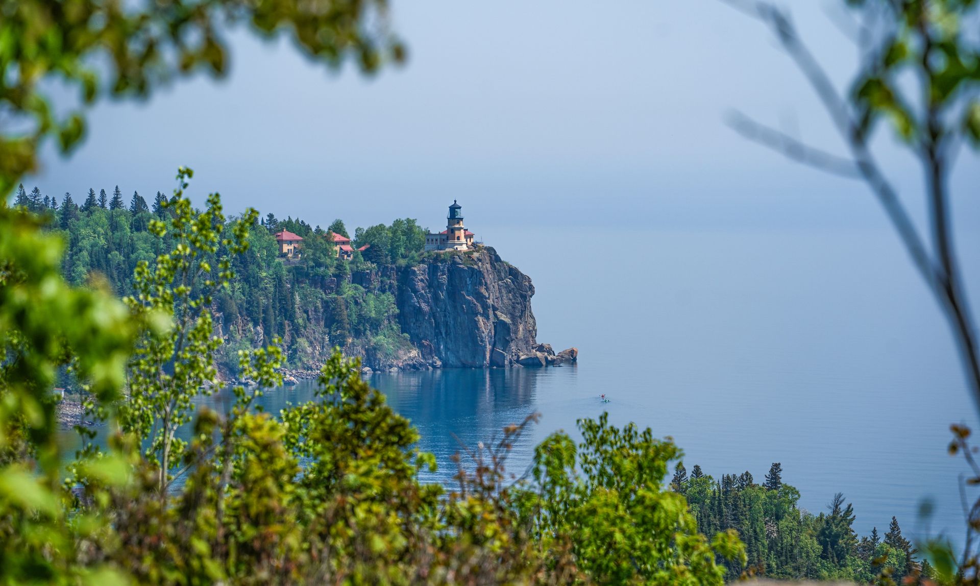
Day Hill Loop, Split Rock Lighthouse State Park
- 3.5 miles
- 423 ft of elevation gain
- Rated moderate
- $7 day fee
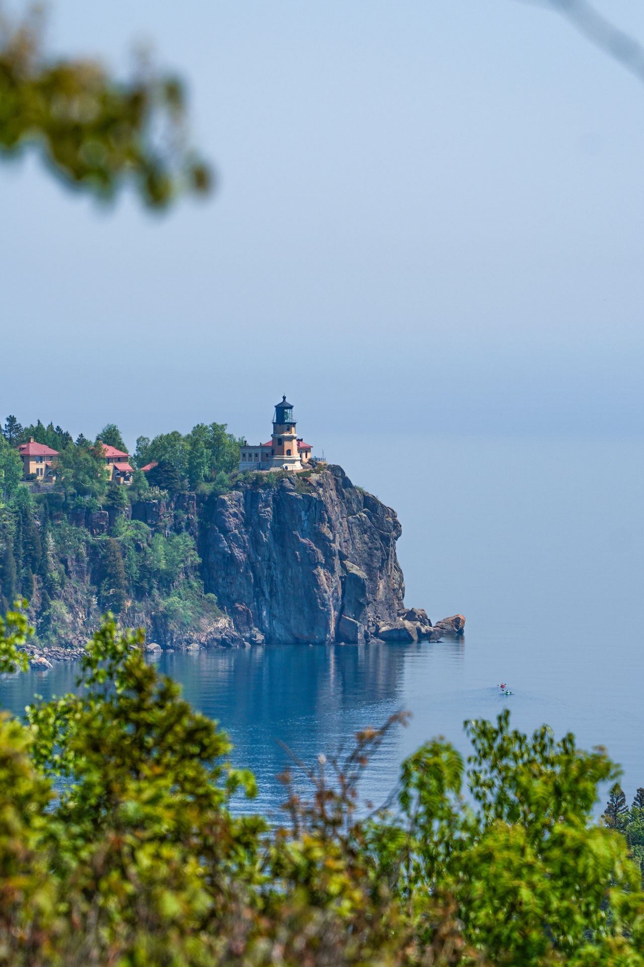
The Day Hill Loop in Split Rock Lighthouse State Park is another must-do trail along the Minnesota North Shore (in my opinion, at least!). This short hike will reward you with a fantastic view of the Split Rock Lighthouse and stunning views of Lake Superior in both directions.
You’ll begin by parking at Pebble Beach and walking along the shore for a bit. The beach area also has a good view of the lighthouse if you’d prefer not to hike up the hill.
To hike up Day Hill, you’ll follow the route past some campsites before reaching the steep, but short, climb. When you reach the top, you’ll notice a giant stone fireplace right away. Legend has it that local businessman Frank Day purchased the land in the early 1900’s to build a dream home for his partner. He began by building the fireplace. However, she left him before he could finish, and the fireplace was left abandoned.
Just past the fireplace, you’ll get to admire the lighthouse, the various surrounding islands and the Lake Superior shoreline.
Apparently on a clear day, you can see all the way to the Apostle Islands in Wisconsin (30 miles away)!
This was easily one of my favorite trails on the North Shore and is another hike that provides fantastic views for relatively low effort.
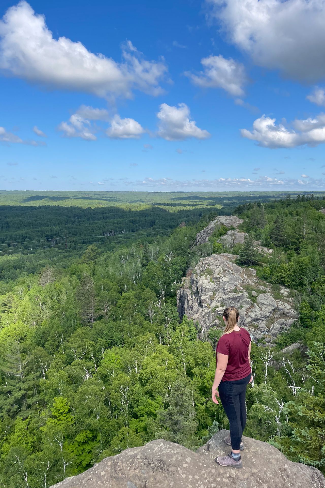
Oberg Mountain
- 2.3 miles
- 508 ft of elevation gain
- Rated moderate
- Free
Oberg Mountain is another magnificent trail on the North Shore. A short climb will lead you to a loop around the mountain with a view of Oberg Lake in one direction and Lake Superior on the opposite side.
You’ll need to take a short dirt road to reach the trailhead, but any car should be able to make it.
I took the loop in the clockwise direction and enjoyed several views of Oberg Lake to start. Another cool aspect of this trail was a series of educational signs about local cryptids and legends (such as BigFoot, Paul Bunyan and Babe the Blue Ox, and more). Discovering each of these would make for a fun activity with kids!
Ely’s Peak
- 1.8 miles
- 396 ft of elevation gain
- Rated moderate
- Free
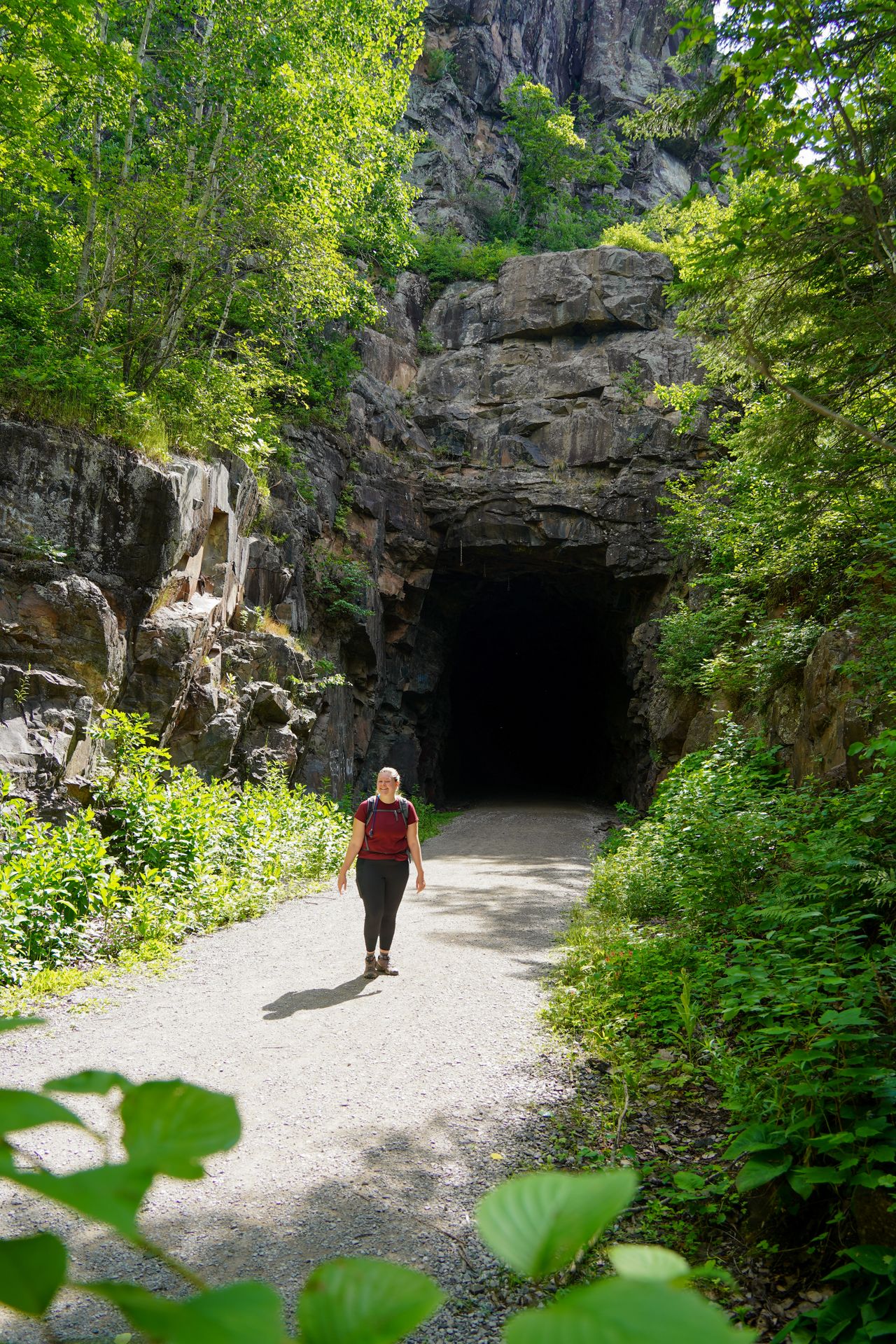
This hike in Duluth is a lot of fun! It’s a great trail to include in your Duluth itinerary. The peak itself offers great views of the area, plus you’ll have the opportunity to walk through a large, historic railroad tunnel.
You’ll start with a flat, paved path, which is popular for biking and rollerblading. After 0.4 miles, you’ll turn left and begin the hike to either the tunnel or the peak. There is a fork in the trail right away. Going right will lead you to the peak, while going left will lead you to the tunnel.
We hiked to the peak first. There are a couple different areas up here to spread out and enjoy the surrounding views. You also may get to see rock climbers nearby!
As you come back down, don’t rely on AllTrails to lead you to the correct turn to the tunnel. I found that it was quite inaccurate. You’ll need to backtrack a little ways until you find a shortcut trail that will lead you over to the trail that will take you to the tunnel.
When you reach the tunnel, it’s an impressive sight. You can walk through it and admire the jagged rocks. The tunnel was built in 1911 for the Duluth, Winnipeg, and Pacific Railroad. Eventually, the railroad was abandoned and the tracks were removed in the mid-90’s. Today, it is part of the Superior Hiking Trail (SHT).
This hike offers a great mix of views and challenges, and is a great option if you’re looking for the best hikes in Duluth.
Non-Hiking Views on the MN North Shore
In case you want to visit more scenic viewpoints before or after your hikes, here are a couple viewpoints to enjoy along the way. (listed from North to South)
- Susie Islands Overlook
- Artist’s Point in Grand Marais
- Black Beach
- Iona's Beach Scientific & Natural Area (SNA)
- Agate Bay Beach
- Duluth Rose Garden
Final Thoughts
I hope this helps you discover which hikes along the Minnesota North Shore are right for you! From waterfalls to epic lake views, this area is sure to dazzle kids and adults alike.
For more Midwest travel guides, check out these blogs:
- How to Spend 2 Days in Duluth
- The Perfect Isle Royale Itinerary
- How to Spend 3 Days on the MN North Shore
- The Perfect Michigan U.P. Itinerary
- How to Take a Perfect Day Trip to Mackinac Island
- How to Spend 3 Days in Madison, Wisconsin
- The Best Outdoor Adventures in St Cloud
- The Best Hikes in Indiana
- The Best Things To Do in Hocking Hills, OH
- The Best Things To Do in Cuyahoga Valley, OH
- The Best Things To Do in Cedar Rapids, IA
Thanks for Reading!


Let's stay in touch!
Join the Lost with Lydia email list to get monthly travel guides and tips!