White Mountain National Forest in New Hampshire is one of the best places to hike in the United States (in my opinion, at least!). The region has mountains, waterfalls, beautiful rock formations and incredible foliage in the fall. Whether you want the challenge of climbing a 4,000 foot peak or an easy trail with spectacular views, this area has it all.
I spent 2 weeks in the White Mountains in September/October 2022 and was blown away by the beauty. Keep reading to learn about the best hikes in the White Mountains and tips for having a great trip.
Pro Tip: If you’re new to hiking, AllTrails is a great tool to use for navigation, recent trail reviews and more. If you do a lot of hiking, I highly recommend paying for AllTrails Plus to access offline maps and the “Lifeline” feature, which allows you to send your location to a trusted friend or family member.
Safety: I highly recommend wearing hiking shoes with traction and bringing the ‘10 essentials’ on any hike. It’s better to be over prepared than underprepared! I also carry the Garmin InReach Messenger, which can be used to call for help in an emergency where there is no service.
Leave No Trace: Please make sure to always leave no trace, no matter what trail you’re on! The principles of leave no trace are:
- Pack out all of your trash (including food scraps)
- Do not feed or approach wildlife
- Travel on durable surfaces (for example - walk through the mud instead of around so not to widen the trail)
- Respect those around you (keep your volume down)
- Respect the local rules for building fires
- Leave what you find (please do not collect rocks or anything else)
Tips for Visiting the White Mountains
- Cell service is spotty in this area and some trails will have service while others won’t. Download offline maps on both google and AllTrails ahead of time, and make sure you have a backup battery.
- The weather can change quickly in the mountains, be sure to keep an eye on the forecast before heading out and prepare accordingly. I recommend checking mountain-forecast.com.
- Some of the trails on this list get super crowded (such as Artists Bluff, Franconia Ridge and Mount Willard). Arrive early for the most popular trails in order to get a parking spot and beat the crowds.
- There is a hiker shuttle that connects several of the major peaks in the White Mountains. Check their schedule here and make a reservation by calling.
- Dogs are allowed on most of these trails! Be sure to keep them on a leash and clean up after them.
While it should not necessarily be your only source for information, AllTrails is a great tool to see trail maps, read recent reviews and learn about the terrain. If you’ll be hiking in areas with no cell reception (like the White Mountains!), you will need AllTrails Plus to download offline maps. The cost is typically $36 a year and worth the investment.
When To Visit the White Mountains
White Mountain National Forest is open year round and each season has something different to offer. From November to April, you have a high chance of experiencing snow. (Keep in mind that it could snow anytime of year in the highest elevations). Winter activities include skiing, snowshoeing, dogsledding and more.
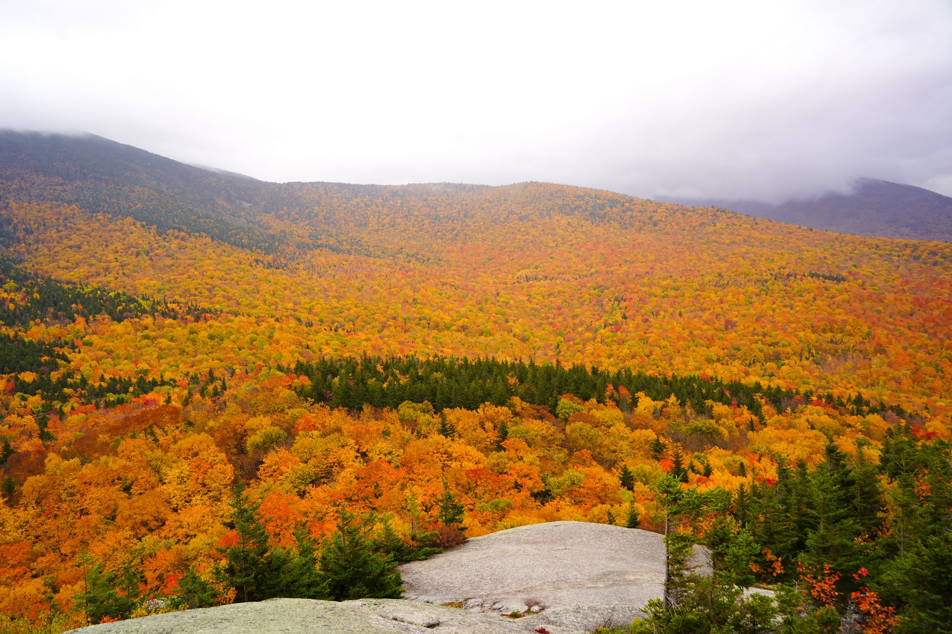
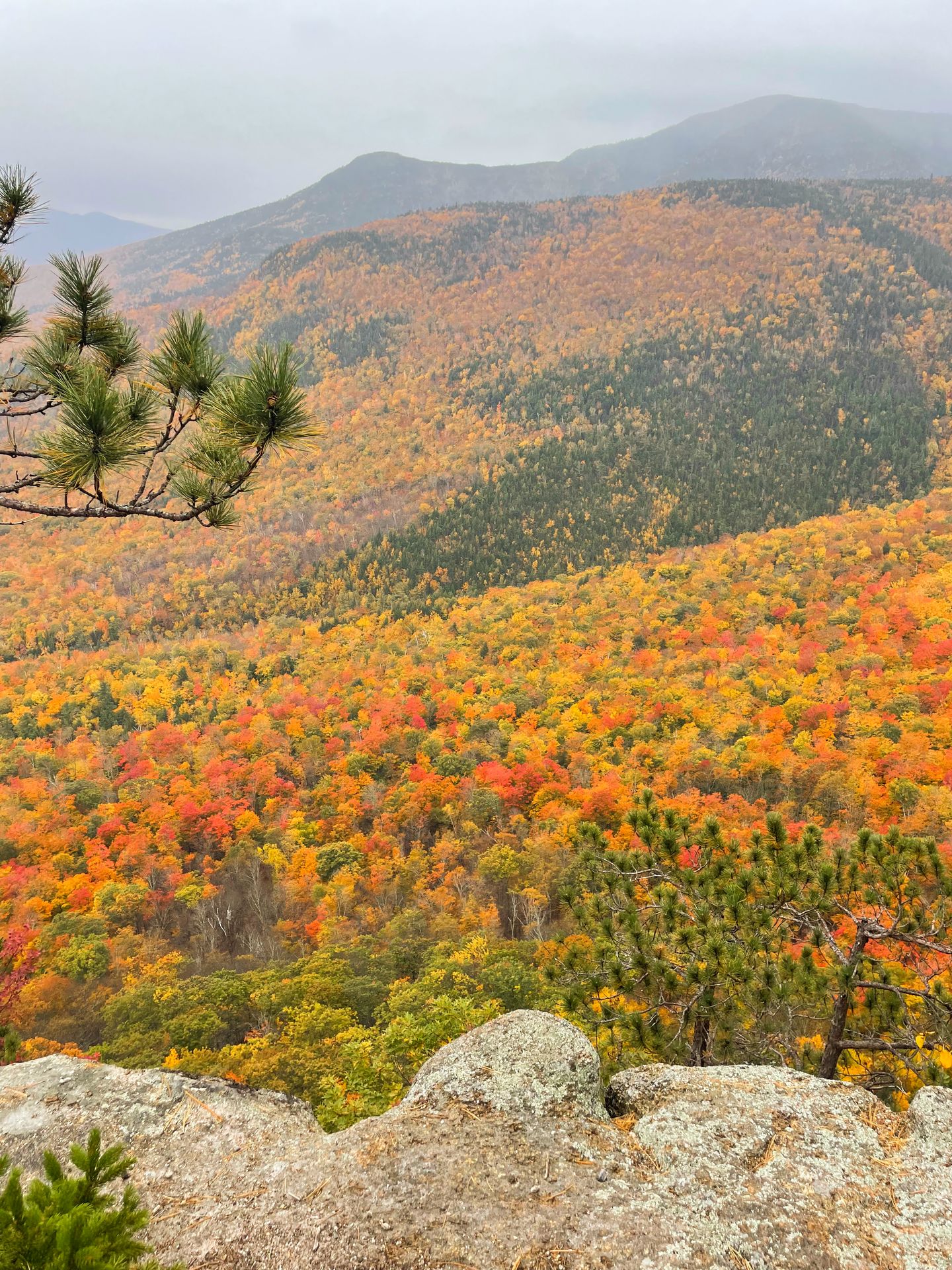
If you are coming to hike and aren’t looking for a snowy trip, you’ll want to visit in the summer or fall. The White Mountains do not get excessively hot in the summer months; the highs rarely exceed 80° F. And in the fall, the White Mountains experience some of the most beautiful fall foliage in the United States.
I timed my visit to see peak fall foliage in the White Mountains and it was most definitely worth it. The date of peak foliage (and its intensity) can vary every year depending on rainfall and other factors. When the time gets close, you can use an online foliage tracker to see how close certain areas are to peak. Even if it’s not “peak” foliage, you can still enjoy beautiful fall colors during the surrounding weeks. Sometimes the foliage may be completely different if you just drive a few minutes.
Typically, peak fall foliage around mid-October (October 9 - 16), so early to mid October is a great time to plan your trip!
Where To Stay in the White Mountains
There are many hotels and short term rental options in the area. I personally recommend basing yourself in Lincoln or Woodstock to be centrally located for the hikes on this list. I had a good experience staying at this Airbnb in the Woodstock/Thornton area.
In Lincoln, there are some great hotels close to restaurants, the beginning of the Kancamagus Highway, Artist’s Bluff and more. Check out the Rivergreen Resort or the Holiday Inn Express & Suites Lincoln East for good value or the InnSeason Resorts Pollard Brook for larger rooms with more amenities.
You can also find many more hotels in North Conway, plus larger stores such as REI and Walmart.
How to Get To The White Mountains
There are no major airports super close to the White Mountains region. If you’re flying, I recommend flying into Portland, ME or Boston, MA and renting a car. Both are under three hours away.
If it’s your first time in the area and you have enough time, you may also want to combine your visit to New Hampshire with a visit to Vermont. Check out my 7 day road trip itinerary of New Hampshire and Vermont for ideas!
10+ of the Best Day Hikes in White Mountains
After spending a little over 2 weeks in the White Mountains region, I completely fell in love with the endless options for hiking trails! Below are details on all of the trails I’ve done, organized by easy, moderate and hard. Trails marked with a * are my favorites.
The Best Easy Hiking Trails in the White Mountains
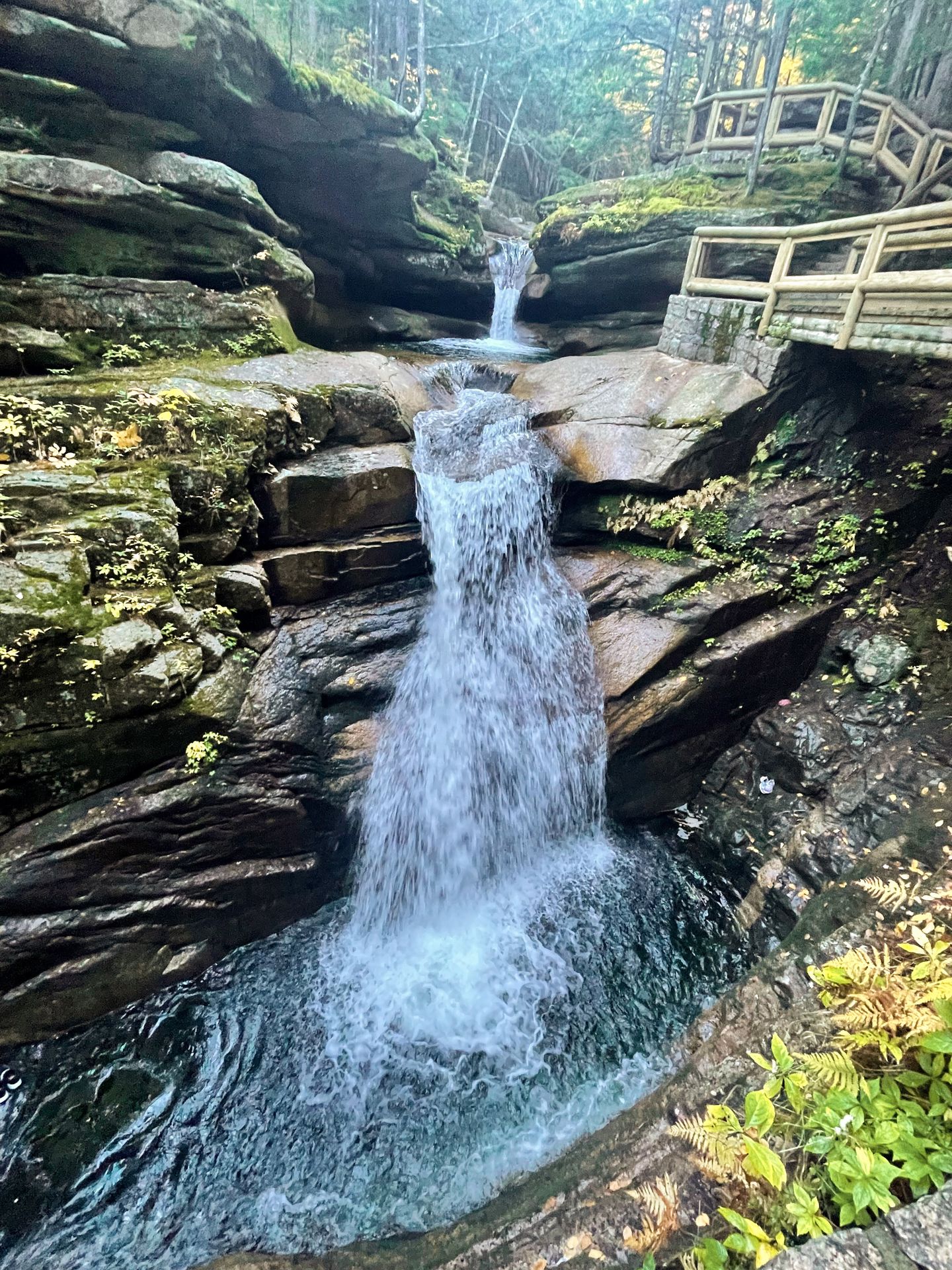
Flume Gorge
- 2.2 miles
- 488 feet of elevation gain
- Rated easy
- Reservations required
- $19 per person
- Restrooms at trailheads
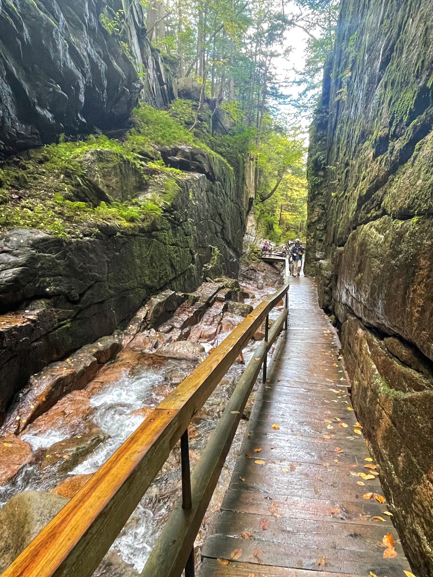
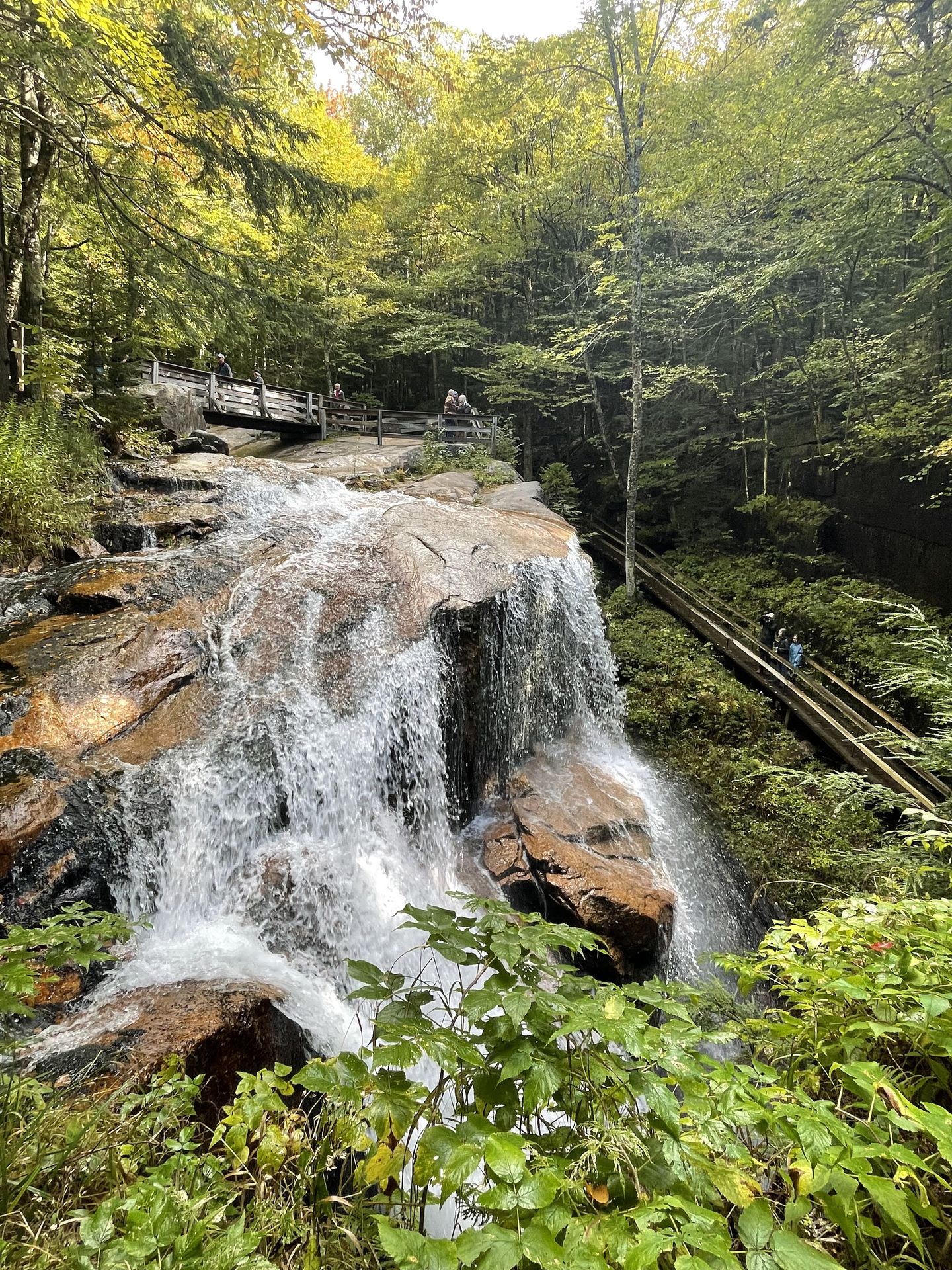
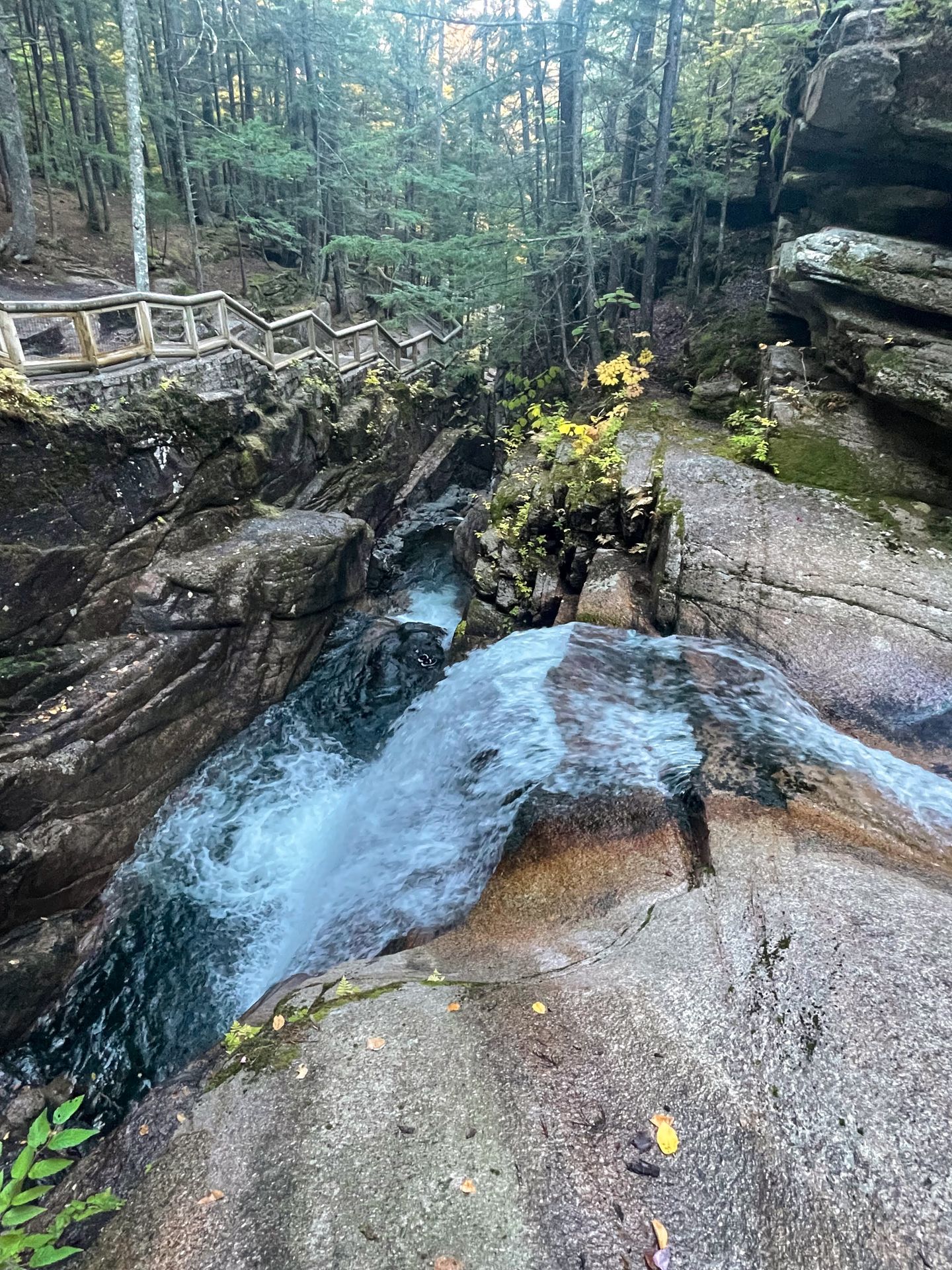
Flume Gorge is a popular trail in the White Mountains for good reason. You’ll hike through a narrow gorge and see waterfalls, giant boulders, moss covered rocks, a covered bridge and more.
Due to the popularity of this area, an advanced reservation is required and the cost was $19 per person in 2022. The area gets crowded during the day and you’ll experience less crowds if you visit when they first open.
The trail is about 2 miles and rated easy. There is a loop and most visitors travel counterclockwise. The trail begins with a red covered bridge and continues into the gorge. This is one of the most beautiful parts of the trail as you walk into the gorge with views of waterfalls along the way.
The gorge area reminds me a lot of some of the beautiful gorges in the Finger Lakes region of New York. If you’ve been to some of those (such as Watkins Glen), I would recommend skipping this in favor of other trails.
After the gorge, continue for more waterfalls and another covered bridge. Towards the end, you’ll also come across the Wolf Den, which is an optional, short offshoot. This was the most exciting part for me! You are able to hike into a narrow slot area where you’ll need to squeeze yourself through the rocks at one point. (Do NOT do this if you’re claustrophobic)
At the end of the trail, you’ll walk through a forest full of giant boulders that were placed by glaciers. There are even tree roots growing around some of them which is cool to see.
Overall, this trail is a must if you’re looking for easy hikes and haven’t been to a gorge like this before.
Sabbaday Falls
- 0.7 miles
- 101 feet of elevation gain
- Rated easy
- $5 parking fee or you can use the America the Beautiful pass
- Restroom at trailhead
Sabbaday Falls is a beautiful and quick trail along the Kancamagus Highway. It leads to a waterfall that seemingly takes a sharp turn as it flows through a narrow gorge. Plus, there are multiple levels of the water and the pools of water have beautiful blue and green colors.
The trail begins relatively flat through the forest. After about a quarter mile, you’ll reach a short loop at the falls that allows you to see it from the base and from above.
I’ve heard this trail gets very crowded, but I had it all to myself early in the morning on a weekday.
The Best Moderate Hiking Trails in the White Mountains
Artist’s Bluff
- 1.5 miles
- 436 feet of elevation gain
- Rated moderate
- Free
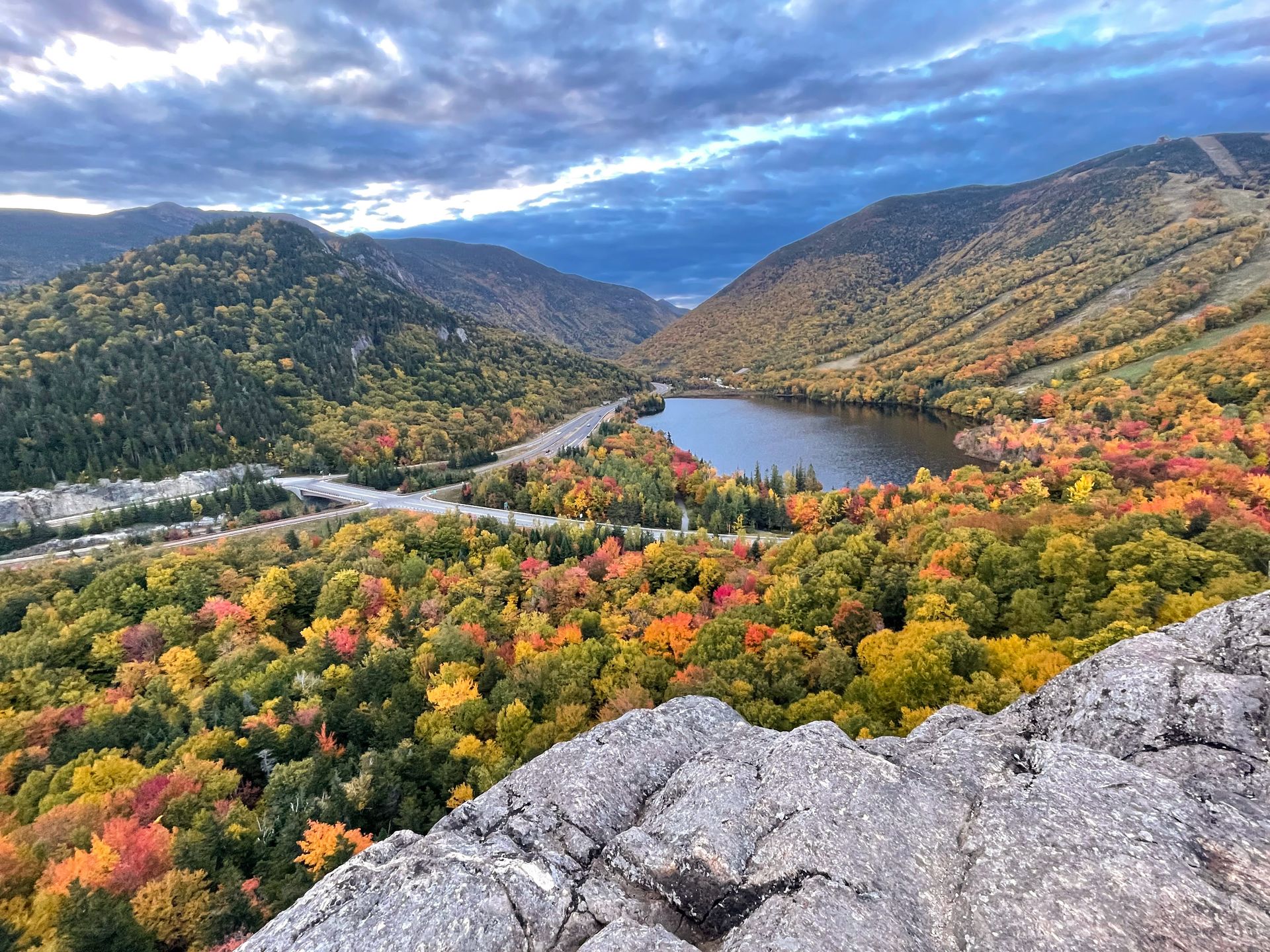
Artist’s Bluff is one of most popular trails in the area for good reason. The short hike leads to an incredible view of a lake and the surrounding mountains and it’s especially stunning in the fall. Because of the popularity, this trail is extremely crowded.
If you really hate crowds, I would avoid it altogether. But if you want to visit at the least busy time, I highly recommend going at sunrise on a weekday. This is when I went and the crowds were very manageable.
There are a couple of different options for parking here. I parked at Lot 4; this is where the AllTrails map begins and it is labeled on Google Maps as the “Artist’s Bluff Trailhead.” You can also park at Cannon Mountain RV Park, which allows for a shorter climb to reach Artists Bluff.
From the main parking lot, travel counterclockwise and you’ll reach Artist’s Bluff in a little over half a mile. After watching sunrise at Artist’s Bluff, I continued on the loop trail to Bald Mountain.
Bald Mountain was my favorite part because we had it all to ourselves and it offered amazing 360 views. You do not have the same epic view of the lake as Artists Bluff, but you have some amazing views of the surrounding mountains. There is a bit of rock scrambling to get up Bald Mountain, so make sure to wear proper hiking shoes.
Overall, the trail is quite crowded but for good reason. If you can manage to be up early and beat the crowds, you’re sure to enjoy it. If you try visiting in the middle of the day or at sunset, you may find yourself shoulder to shoulder with many others.
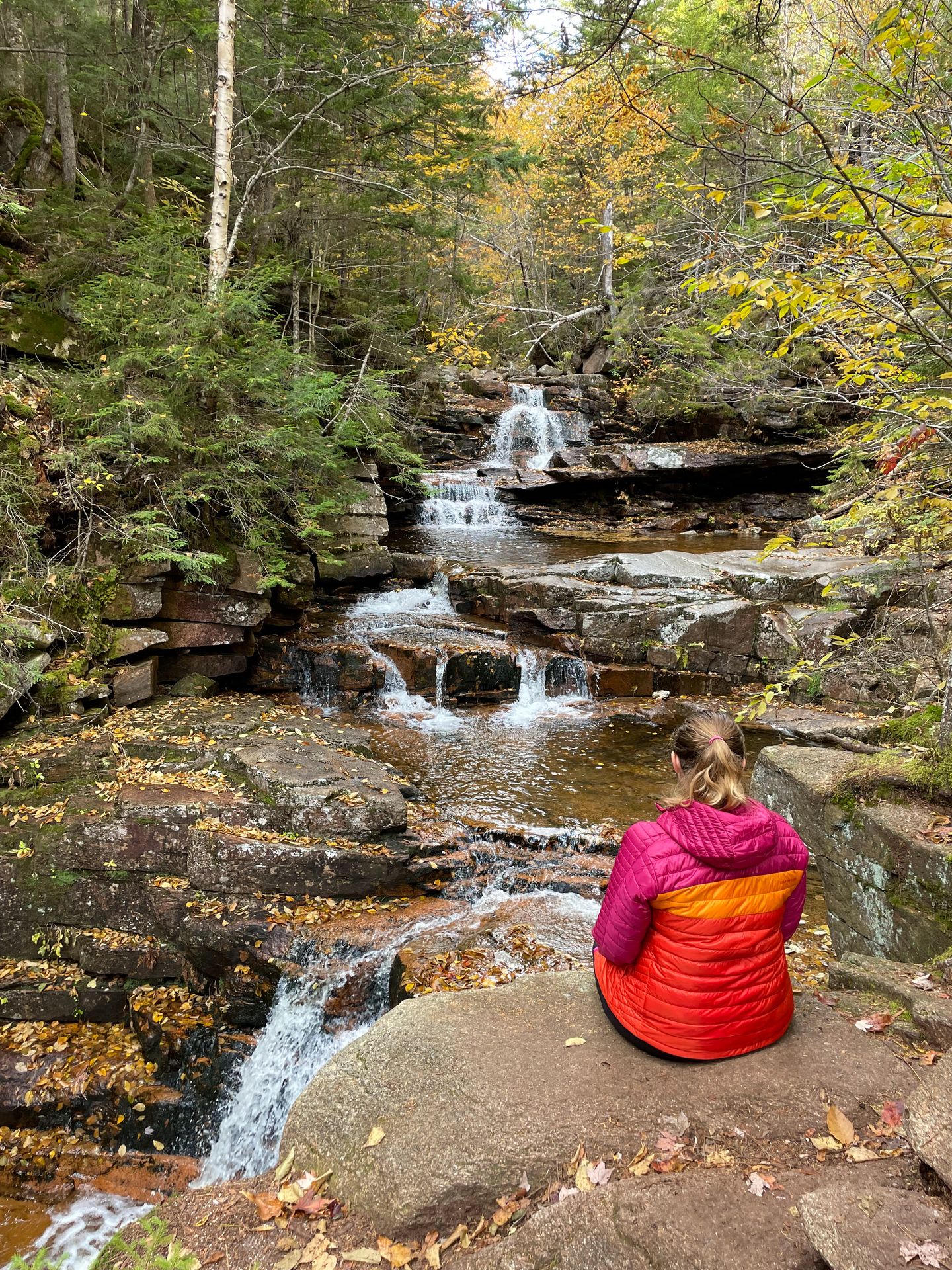
Champney Falls *
- 3.1 miles
- 682 feet of elevation gain
- Rated moderate
- $5 parking fee or you can use the America the Beautiful pass
- Restroom at trailhead
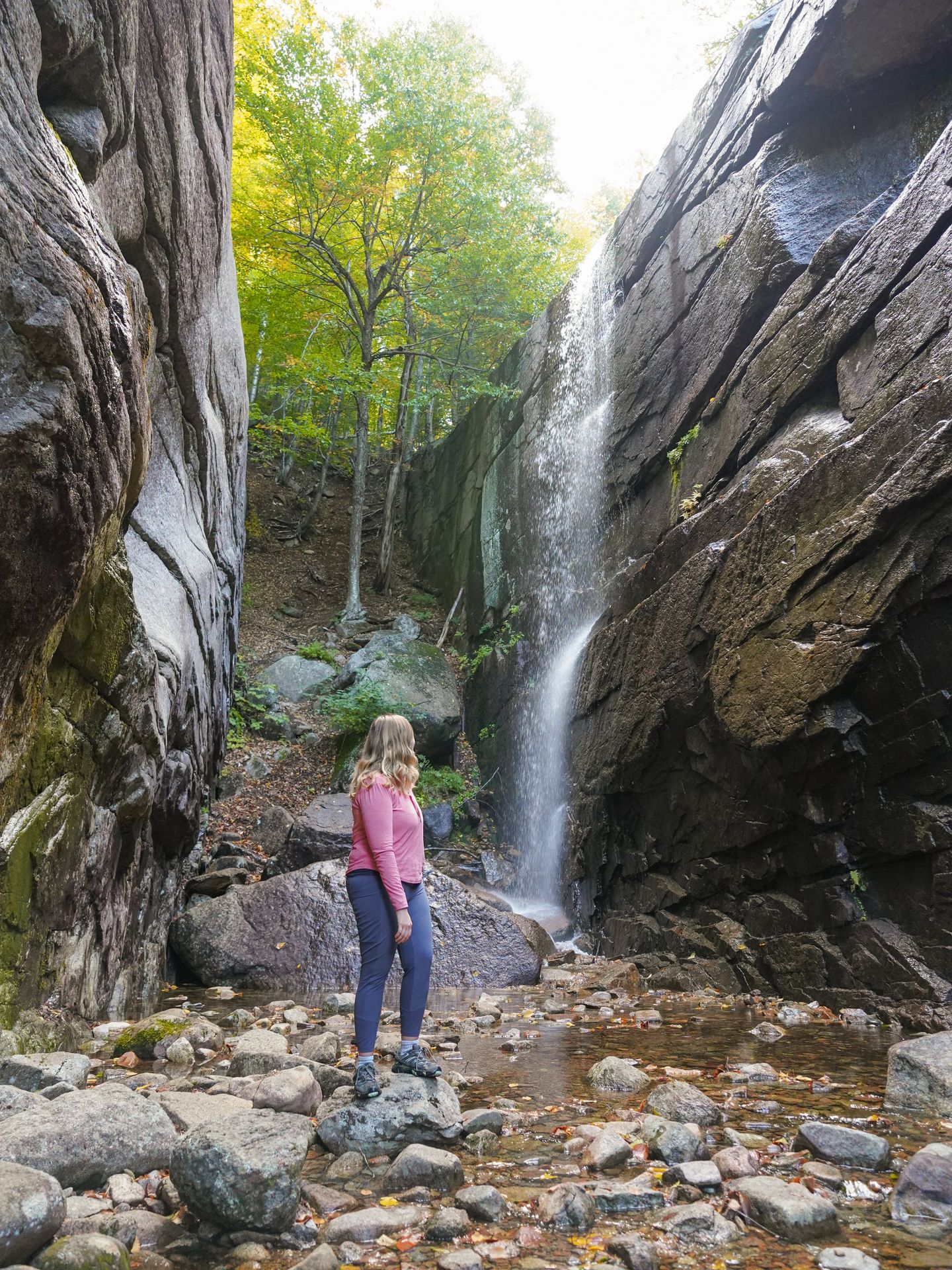
Champney Falls is another great waterfall trail along the Kancamagus Highway. The trail begins with a relatively easy walk through the forest with gradual elevation gain. When you reach the waterfall, you’ll find that there is more than first meets the eye.
You’ll first come across a standard waterfall right next to the trail with a giant rock slab in front of it.
Cross the water using rocks and walk past the giant rock slab. (It was doable for me without getting my feet wet.) Enter in the gorge, stand under the towering rock walls and you’ll see water tumbling off the top of the cliff. It’s a really unique waterfall that was fascinating to see.
I really enjoyed this hike! It’s a great hike to add as a stop along the Kancamagus Highway.
Mount Willard
- 3.1 miles
- 895 feet of elevation gain
- Rated moderate
- Free
- Restrooms at trailhead (at train station)
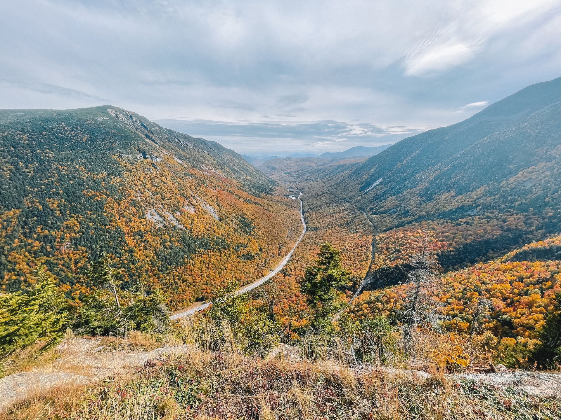
Mount Willard is a popular trail and leads to a beautiful view of a valley between two mountains. It is especially beautiful in the fall when the foliage colors the scene bright yellow.
The trail begins behind the Crawford Notch train station. You can park in front of the train station or across the street, but the area gets busy when a train is about to leave. Cross the train tracks to reach the trail.
You will turn left right away on the trail to begin heading up. The trail is well marked, but many people accidentally continue straight, so I recommend having the AllTrails map downloaded.
The trail is a bit steep and can be slippery and muddy. Make sure to wear proper hiking shoes.
The view at the top is very rewarding and worth the climb. There isn’t a ton of space, but just enough so you can spread out and have lunch. You’ll be able to see the Crawford Notch Road, the train tracks and the surrounding mountains.
Tip: Make quick stops at the Silver Cascade and Flume Cascade. These waterfalls are right along the road just south of Mount Willard.
Boulder Loop Trail
- 3.4 miles
- 925 feet of elevation gain
- Rated moderate
- $5 parking fee or you can use the America the Beautiful pass
- Restroom at trailhead
The Boulder Loop trail is another trailhead located along the Kancamagus Highway. There is a covered bridge near the base of the trail and you can either drive through to reach the closest parking lot, or park next to the bridge and walk over.
The trail is a loop and the elevation gain will get your heart pumping a bit. It is almost entirely in the woods (shady!) and there are some beautiful boulders along the way. Download the AllTrails map to make sure you don’t miss the turn at the top. The views are along a spur trail that comes off of the loop.
When you take the spur trail, there are a couple different areas with great views. You’ll be able to see the Kancamagus Highway and the surrounding mountains. As you make your way down, there are various other viewpoints along the way.
This hike is a bit more underrated than many of the others on this list, so it’s a great place to go to avoid the crowds.
East Rattlesnake Trail
- 1.2 miles
- 564 feet of elevation gain
- Rated moderate
- Free
- No restrooms at trailhead
The East Rattlesnake trail is located about 50 minutes south of Lincoln, so it’s about a bit outside of the main area of the White Mountains. However, the short climb provides amazing views and it’s a great trail for sunrise.
You’ll drive through a neighborhood to reach this trail and there is limited parking, but entry is free. The trail is steep but short and you’ll have an epic view of Squam lake. You can even see a fire tower in the distance. There are other trails in the area too if you want to extend your time.
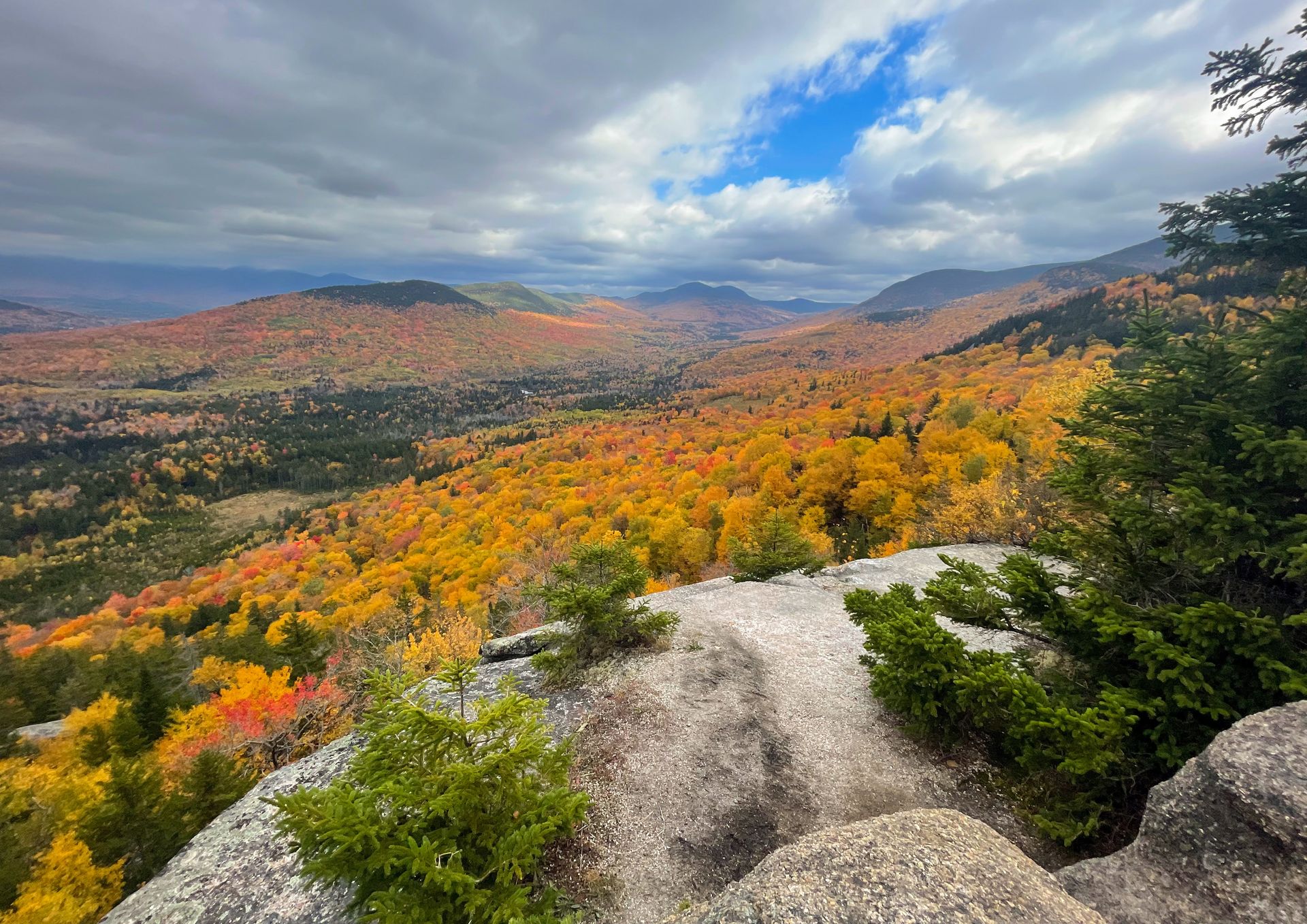
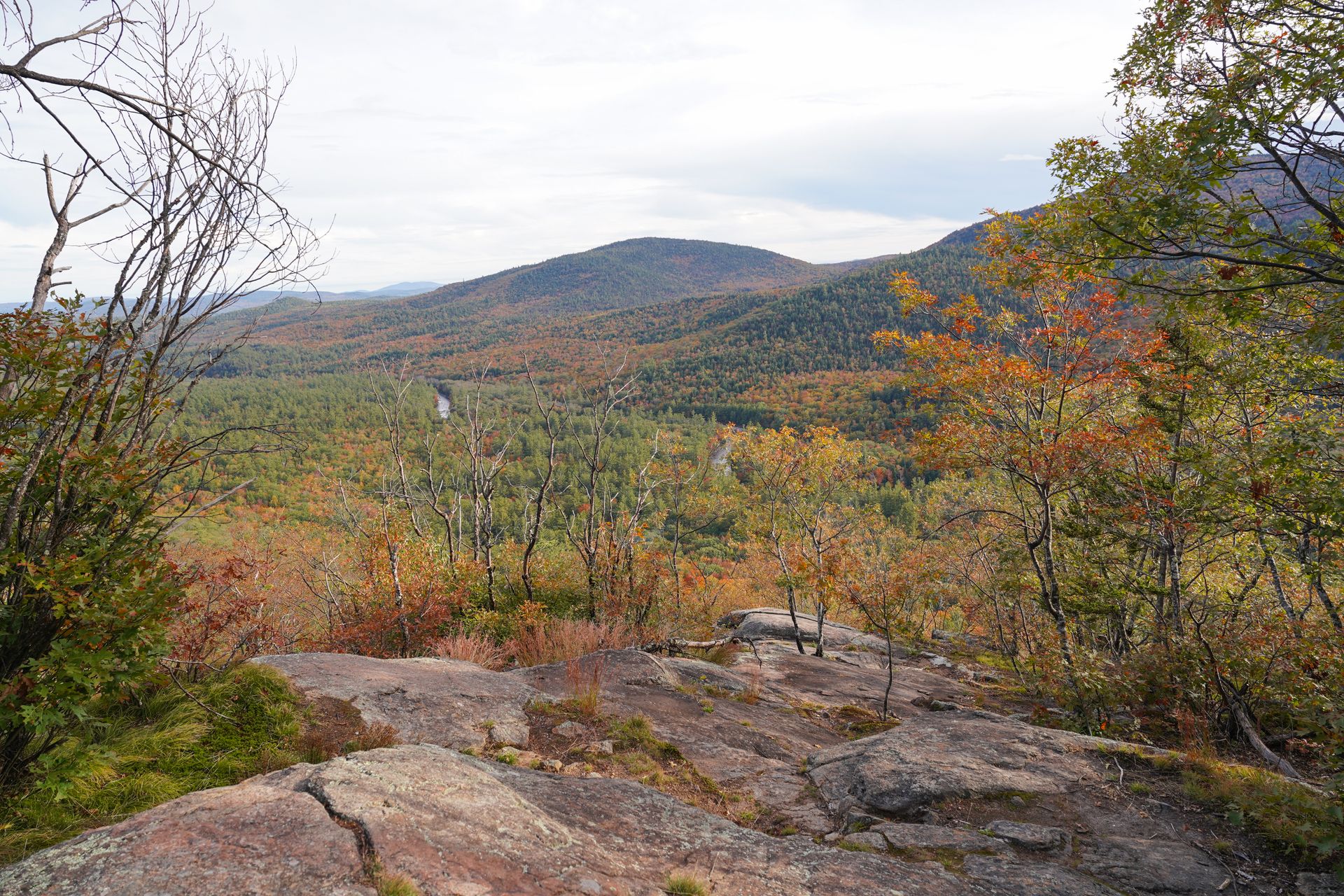
North and Middle Sugarloaf *
- 3.3 miles
- 1,069 feet of elevation gain
- Rated moderate
- Free
- No restroom at trailhead
The North and Middle Sugarloaf peaks trail will allow you to see the vast and vibrant colors of foliage in the fall. You will hike up to two peaks for this trail, but you could also just choose one if you’re short on time.
The trail begins flat and soon reaches some rocky and steep areas. As you climb up, you’ll come to a fork between North and Middle Sugarloaf. Middle Sugarloaf has more expansive views and more space to spread out, but I still felt that there were both worth doing.
This was one of my favorite trails and is a great one to do if you’re visiting during peak foliage.
The Best Hard Trails in the White Mountains
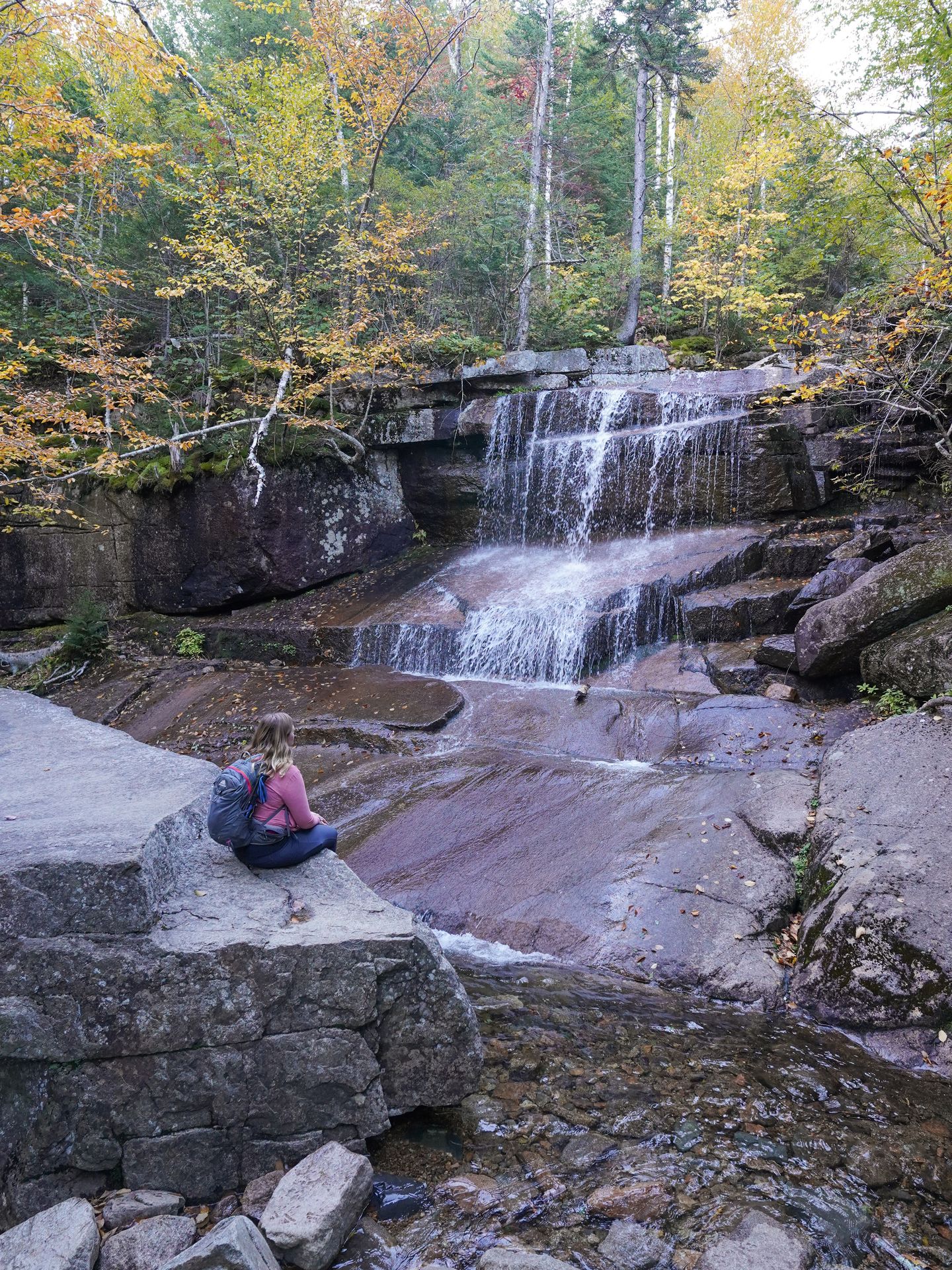
Frankenstein Cliff and Arethusa Falls
- 4.9 miles
- 1,637 feet of elevation gain
- Rated hard
- $5 fee for parking at Crawford Notch State Park
- Restrooms at trailhead
The Frankenstein Cliff and Arethusa Falls loop has a little bit of everything - train tracks, expansive views, waterfalls and more. It is a loop that is best taken counterclockwise so you can climb up the steepest area instead of down.
Towards the beginning, the trail will lead you under a trestle bridge for Conway Scenic Railroad. Some visitors venture off of the trail to take photos from on top of the train bridge, but this can be very dangerous. Please use extreme caution and check the train schedule if you decide to do this.
After the train tracks, you’ll climb up a steep hill. There are a couple of different viewpoints at the top with nice views of the mountains and hills below. You will soon climb down and reach the spur trail for Arethusa Falls. This was by far the most crowded area of the trail but the waterfall is beautiful.
Finally, this is optional but I turned onto the Bemis Brook Trail coming back and was really impressed with the additional waterfalls along this trail. It’s a steep rock scramble to get down to this trail, but worth it. Bemis Falls and Coliseum Falls are both beautiful and this area is much quieter than Arethusa Falls. The trail connects back to the Arethusa Falls trail and you can continue the loop back to the parking lot.
Welch Dickey Loop *
- 4.4 miles
- 1,778 feet of elevation gain
- Rated hard
- $5 parking fee or you can use the America the Beautiful pass
- Restroom at trailhead
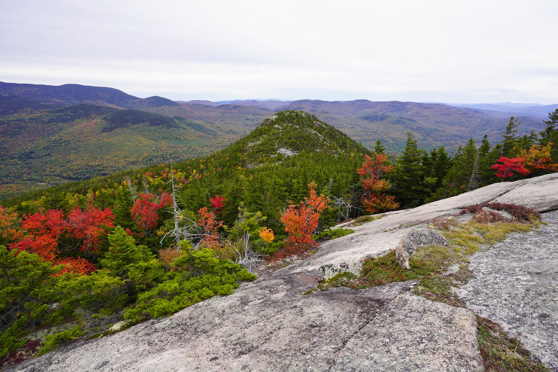
The Welch Dickey Loop another one of my favorite trails in the White Mountains area. You will hike a loop and conquer both the Welch and Dickey Peaks with a multitude of views along the way.
It is best to go counterclockwise so you can hike up some of the steepest areas instead of down. Proper hiking shoes are a must for this trail because there are many areas where you’ll be climbing up slick rocks and will need to rely on the traction of your shoes.
The first overlook is just over a mile into the hike, and then you’ll enjoy almost constant views. You can also turn around after the overlook if you’re nervous about the climb or short on time. From there, you’ll continue up to the Welch Peak and then the Dickey Peak. The Welch Peak had slightly better views in my opinion.
Overall, this trail has some of my favorite views and offers a lot of wow factor for it’s distance. I highly recommend adding it to your New Hampshire itinerary.
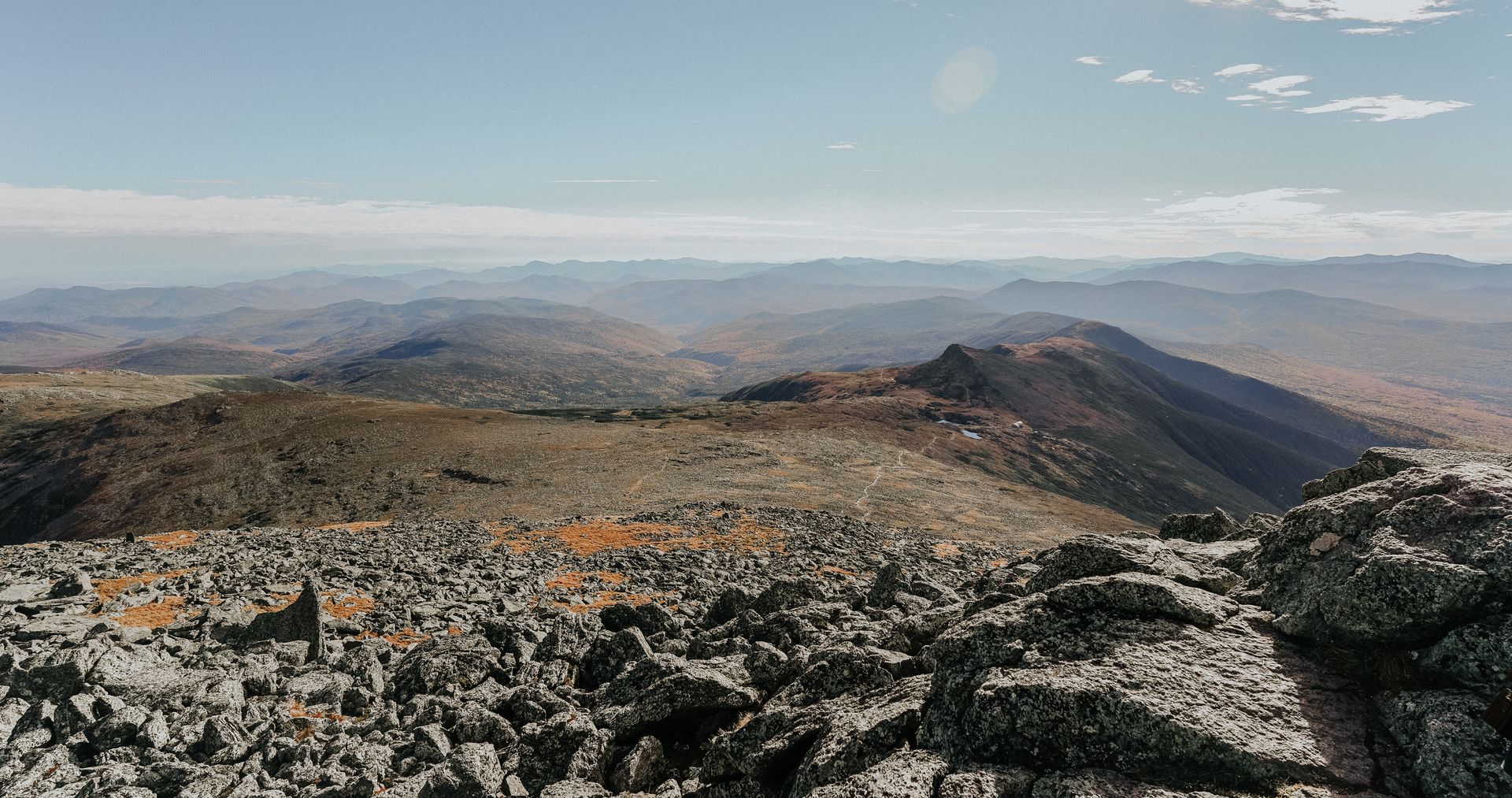
Mount Lafayette and Franconia Ridge Trail *
- 8.1 miles
- 3,795 feet of elevation gain
- Rated hard
- Free
- Restrooms at trailhead
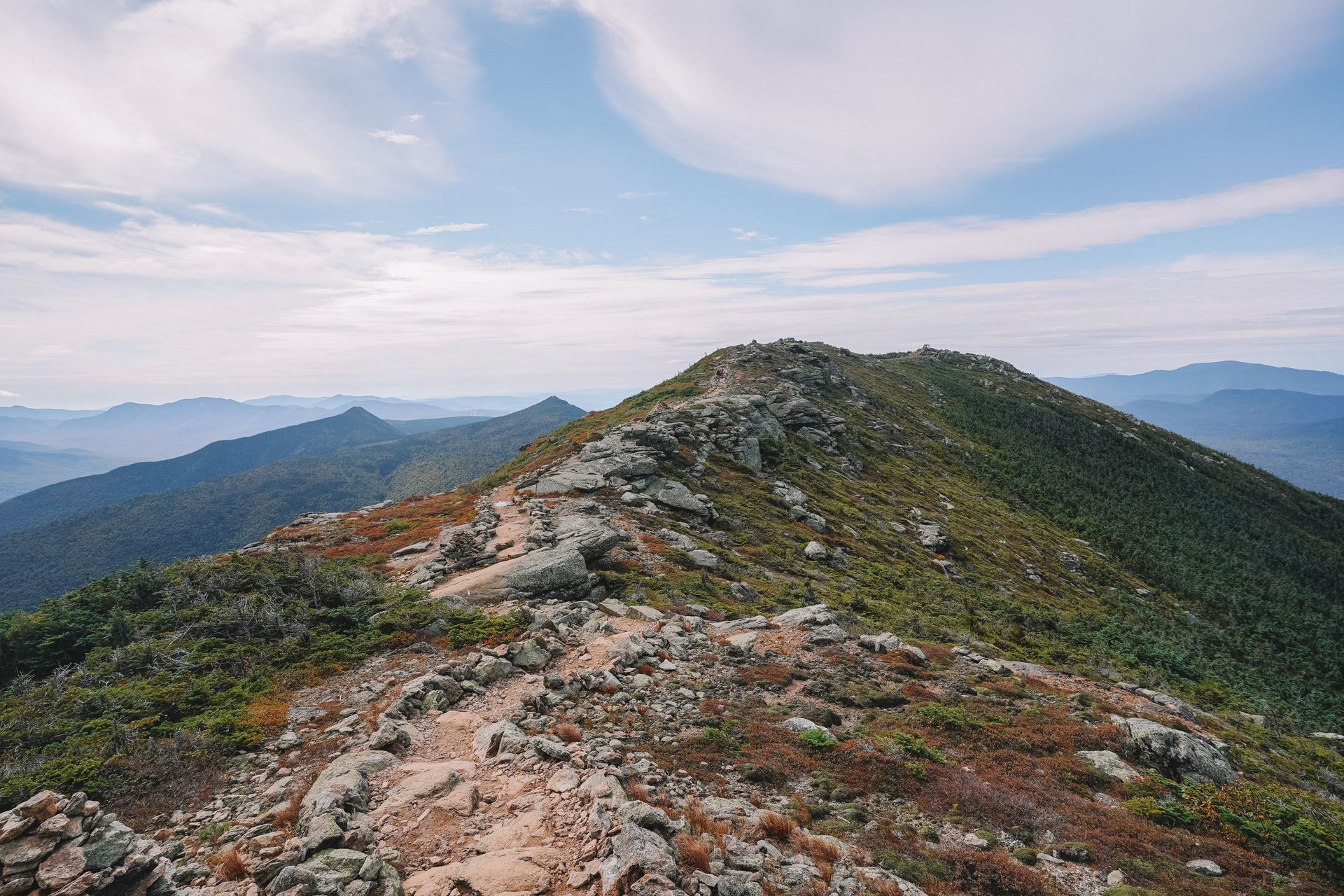
Finally, I’m ending the list with one of my all time favorite trails - the Mount Lafayette and Franconia Ridge Loop. This trail can be very difficult, so please only attempt it if you’re an experienced hiker and you come prepared. If you’re up for the challenge, the trail is incredibly rewarding and full of variety.
Be sure to check the weather forecast before attempting this hike. The mountain peaks can often see high winds, snow and ice even if the weather is okay at the base.
The trail is 8.1 miles with over 3,000 feet of elevation gain. It is a loop and most go counterclockwise in order to climb up the steepest section of rock scrambling instead of down.
The adventure begins on the Falling Waters trail where you will see several waterfalls with several water crossings. There is a lot of rock scrambling here and some areas may be slippery, so be careful. After a little under 3 miles, you’ll reach Haystack peak and be rewarded with 360 views of the area.
On this trail especially, you’ll notice that there are very few switchbacks on trails in this area. Instead, they are often built straight up and require a lot of rock scrambling. Do not underestimate this hike!
The trail then follows along the ridge for another 1.5 miles. This is the best part of the trail. You will hike among alpine landscapes and enjoy views for mountainous views for miles. While hiking along the ridge, you’ll climb 4 peaks and two of them are over 4,000 feet.
After reaching the top of Mount Lafayette, you’ll begin making your way down. A little over a mile after the peak, you can stop for food, water, warmth and a restroom at the Greenleaf Hut. The hut provides lodging for thru hikers and backpackers, but also serves food to day hikers at affordable prices. When I was there, they were serving potato dill soup, coffee, bread and lemonade. They also have some items for sale like chapstick and books to borrow. They don’t take credit cards, so bring cash or you can pay via venmo.
After you’re properly warm and fed, begin the 3 mile trek back down to complete the trail. This portion was harder than I thought it would be - there is a lot of rock scrambling going down and some areas are quite slippery.
Overall, this hike is challenging but so much fun and extremely rewarding. It certainly made me want to return to hike more 4,000 feet peaks in the future.
Hikes on my List for Next Time
- Mount Washington: Mount Washington is the highest peak in the Northeastern United States and there are multiple trail options to reach the top. I drove to the peak, but would love to hike next time.
- Flume Slide to Liberty Spring Trail: This is a popular trail for summiting two 4,000 foot peaks with amazing views along the way.
- Mount Garfield: Another 4,000 foot peak with expansive views.
- Mount Carrigan: Another epic 4,000 foot peak trail with a fire tower at the top.
Where to Eat near the White Mountains
You’re sure to work up an appetite after all of this hiking! Here are my favorite restaurants in the area:
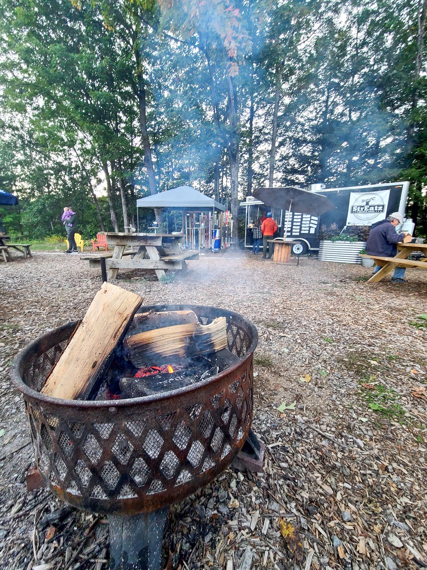

- StrEatz: A food truck in Woodstock that serves eclectic food and a great variety of vegetarian options. I loved the kung pao cauliflower and the zucchini fries.
- White Mountain Bagel Co: A wonderful place to grab a filling breakfast and a coffee in Lincoln.
- Gypsy Cafe: A restaurant in Lincoln that features food from all around the world. I enjoyed the Malai Kofta (an Indian dish) and the Egyptian Brussel Sprouts.
- Cheese Louise: The perfect stop at the end of the Kancamagus Highway! They serve delicious grilled cheese, tomato soup and mac and cheese.
- The Moon Bakery and Cafe: A cute cafe that serves coffee, pastries and other breakfast items.
Things To Do Besides Hiking in the White Mountains
- Drive or take the Cog Railway to the top of Mount Washington! This is the highest mountain in the Northeastern United States, so the views on a clear day are epic. It’s expensive to drive or take the train, but worth it in my opinion.
- Take the Conway Scenic Railroad. This is a great fall activity to see the foliage from the comfort of a train car.
- Stop at all of the scenic viewpoints along the Kancamagus Highway! There are so many overlooks, streams and waterfalls along the way. Keep an eye out for moose.
- See the former site of the Old Man in the Mountain at the Profile Plaza. There used to be a rock formation that famously resembled a face, but it fell in 2003. Today, there is a plaza where you can line up part of a face to the place on the rock, so you can see what it used to look like.
For more of the best things to do in the White Mountains, check out my guide!
Final Thoughts
I hope this New Hampshire hiking guide helps you plan an epic hiking trip to the New Hampshire White Mountains! It is such an incredible hiking destination in New England and I hope you love it as much as I do.
For more New England and New York Travel Guides, check out these blogs:
- A Guide to Driving the Kanc Highway
- How to Spend One Day in Boston
- The Best Hiking Trails in Acadia National Park
- 7 Day Fall Road Trip Itinerary for New Hampshire and Vermont
- How to Spend 3 Days in Acadia National Park
- How to Spend 1 Day in Acadia National Park
- The Ultimate Fall Guide to Acadia National Park
- The Best Hiking near Ithaca, New York
- The Ultimate Winter Guide to Buffalo, New York
- The Perfect Day Trip to Connecticut
- The Perfect 5 Day New England Road Trip
- How to Spend 1 Day in Rhode Island
- An Epic 10 Day New England Road Trip
- The Best Things To Do in North Adams, MA
Thanks for Reading!


Let's stay in touch!
Join the Lost with Lydia email list to get monthly travel guides and tips!