From towering orange cliffs to colorful canyons to rocky spires, Utah is full of otherworldly landscapes. If you enjoy the outdoors, a trip to Utah’s Mighty Five is likely on your bucket list. This Utah Mighty 5 itinerary provides a guide on how you can visit all 5 of the Utah national parks during one road trip. I recommend the best things to do in each park, where to stay along the way and more things you need to know.
What is the Utah Mighty 5?
The Mighty 5 refers to the 5 national parks in Utah: Zion, Bryce Canyon, Capitol Reef, Arches and Canyonlands. All of the parks are located in Southern Utah, but there is still a few hours driving time between each one.
How long do you need to visit the Utah Mighty 5?
This question depends on many factors. Things to consider include: are you a big hiker? What type of pace do you move at while traveling? Are you okay with spending a lot of time in the car?
Personally, I believe you should still travel no matter how little time you have, but I also believe that rushing between parks just to cross them off your list will provide the best experience.
This itinerary is for 12 days and that includes travel time. You could easily spend much longer, or you could cut out a lot of things and spend less time. I feel that 12 days provides you a nice amount of time to see the main highlights of each area.
The itinerary is packed and includes several days of hiking. Along with the top things to do and see in each park, I’ve included some stops between the parks to break up the drive.
Should you Fly into Salt Lake City or Las Vegas for a Utah Mighty 5 Road Trip?
When it comes to where to fly into to visit the Utah Mighty 5, there are several different choices. If your budget allows, there are smaller airports in Utah that are closer to the parks. These airports include St George, Cedar City and Grand Junction (in Colorado). These are certainly worth looking into.
However, most visitors will fly into Salt Lake City or Las Vegas. These airports are much bigger, and therefore have many more options for affordable flights and rental cars. When it comes to Salt Lake City vs Las Vegas, I tend to recommend flying into Salt Lake City if you only plan to visit the Utah parks and it's not during the winter. This allows for less driving time.
However, driving from Salt Lake City means that you'll have to drive through mountain passes as you leave Salt Lake City and drive to the parks. During the winter months, these roads may be snowy and icy, and could cause delays.
If you plan to add the Grand Canyon and Page in Arizona to your itinerary, then Las Vegas is a better choice to fly into. This is also likely a better choice if you're visiting in the winter.
When to Visit the Utah National Parks
The Utah National parks can be visited year round, but I recommend avoiding the summer months due to high heat and monsoon season (heavy rain is possible).
In the winter months, most of the parks will likely still have nice weather, but they may receive snow. Bryce Canyon is at the highest elevation so you’ll likely see trail closures in the winter.
As with many places, the best time to visit is in the Spring or Fall, when you can enjoy mild weather that tends to be perfect for hiking!
Read about the best national parks to visit in the winter
Tips & Things To Know about a Mighty 5 Road Trip
-
Cryptobiotic soil crust is a fragile type of soil that includes living organisms such as algae and fungi. This type of soil is very common in the Utah desert. Just one footstep onto this soil can break the crust that takes decades to recover. This means it is SO important to always stay on the trail when exploring this magical region.
-
Some of the Utah national parks are quite remote. Especially when you’re driving between them, make sure to fill up on gas when you can.
-
I recommend stopping at the grocery when you arrive and planning to eat packed lunches just about every day of this trip. Not only will this save you money, but it will be much more convenient when you’re spending full days in the parks without access to restaurants.
-
Download the Guide Along audio tours for Utah to enjoy while you’re driving! The tours will teach you history about each area and make suggestions of where to stop. It’s a great way to learn about the Utah national parks while you’re in transit.
-
Each park charges an admission fee, so you will save money by purchasing an America the Beautiful Pass that grants you admission into all national parks for a year.
-
Reservations are required to enter Arches National Park (during certain hours and seasons) and for one of the most popular hikes in Zion (Angel’s Landing). More on that when I talk about each place in the itinerary!
-
This itinerary involves a lot of hiking, make sure you’re prepared! Be sure to wear proper hiking shoes and socks, bring plenty of water, have a source of navigation on the trails (I recommend using AllTrails Plus to download offline maps) and carry a first aid kit. For more information on how to be a safe hiker, check out my beginner hiking guide.
-
Finally, use this itinerary to create a schedule that works perfectly for you! If you’re not a huge hiker, you’ll likely want to cut a lot of trails that I recommend. If you prefer to move at a slower pace, you may want to add several more days to this trip. Everyone is different and I hope this guide helps you plan a trip that is perfect for you.

Utah Mighty 5 Road Trip Itinerary
12 Day Itinerary Overview:
- Day 1: Drive from Salt Lake City to Moab
- Days 2 - 4: Explore Moab (Arches, Canyonlands and more)
- Day 5: Drive from Moab to Capitol Reef
- Day 6: Explore Capitol Reef
- Day 7: Drive from Capitol Reef to Bryce
- Day 8: Explore Bryce Canyon
- Day 9: Drive from Bryce to Zion, explore Zion.
- Day 10: Explore Zion
- Day 11: Drive from Zion to Salt Lake City
- Day 12: Fly home
Day One
Drive from Salt Lake City to Moab.
On your first day, fly into Salt Lake City, pick up a rental car and drive to Moab. The drive between Salt Lake City and Moab should take a little under 4 hours. I recommend spending at least 3 days in Moab so that you can see both national parks (Arches and Canyonlands) along with some other activites.
If you fly into Las Vegas instead of Salt Lake City, I recommend reversing the itinerary and starting wtih Zion.
Where to Stay in Moab
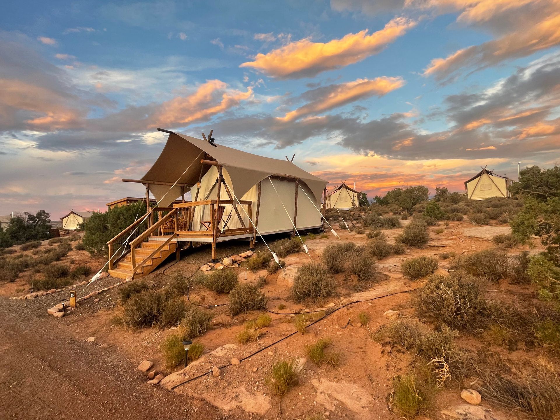
Glamping in Moab
If you enjoy glamping, Under Canvas offers an incredible experience! This accommodation is a community of safari tents complete with comfortable beds, phone chargers, a great community area and more.
Under Canvas is not cheap but is worth the price if you’re looking for a unique experience during your Utah road trip!
Hotels in Moab
Moab also has several more hotels that are more affordable. I personally stayed at Expedition Lodge and it is a great location and family friendly.
Other hotels to choose from in Moab include Best Western Plus Greenwell Inn, The Gonzo Inn and the Hyatt Place Moab.
Camping in Moab
Arches National Park has one campground, the Devils Garden Campground. You can make a reservation between March 1 and October 31, but keep in mind that it is often fully booked.
Luckily, there are several other camping opportunities in Moab, from BLM land to national forests. You can find a list of options from Discover Moab.
Day Two
Explore Arches National Park.
Spend your first day in Moab exploring Arches National Park! Keep in mind that timed entry reservations are required to enter the park between April 1 to July 6th, and August 28th to October 31, between 7 am and 4 pm. You can make your reservations online at recreation.gov. Some are released 3 months ahead of time, while more are released the night before at 7 pm.
In order to maximize your time, I recommend entering during the earliest time slot or entering before reservations are needed (before 7 am).
Fun Fact: There are over 2,000 documented arches in Arches National Park. The park has the densest concentration of arches in the world!
The Best Things To Do in Arches National Park
Here are the top places I recommend visiting during your first day at Arches.
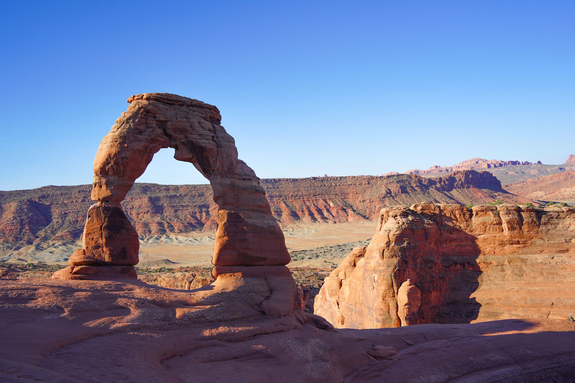
Watch the Sunrise at Delicate Arch
Delicate Arch is the most iconic hike in Arches for good reason - the arch is even featured on the Utah license plate! The hike is 3.2 miles with a little over 600 feet of elevation gain. The trail includes climbing up some steep areas of slickrock, so make sure you come prepared with hiking shoes and plenty of water.
When you reach the top, you’ll be rewarded with a stunning view face to face with the arch. Delicate Arch is especially beautiful at sunrise due to the lighting, and you’ll experience fewer crowds than you would at sunset.
Balanced Rock
Don’t miss Balanced Rock - it’s a quick stop and a really unique place! Balanced Rock is essentially exactly what you would imagine - a giant boulder balanced on a smaller platform. The formation is 128 feet tall. You can see the rock from the parking lot, or take a short, partially paved trail to get closer.
Double Arch
Double Arch is a quick and iconic trail inside the park! It’s about a half mile round trip hike to reach a giant arch inside another arch. It’s a really neat spot that you won’t want to miss during your visit to Arches!
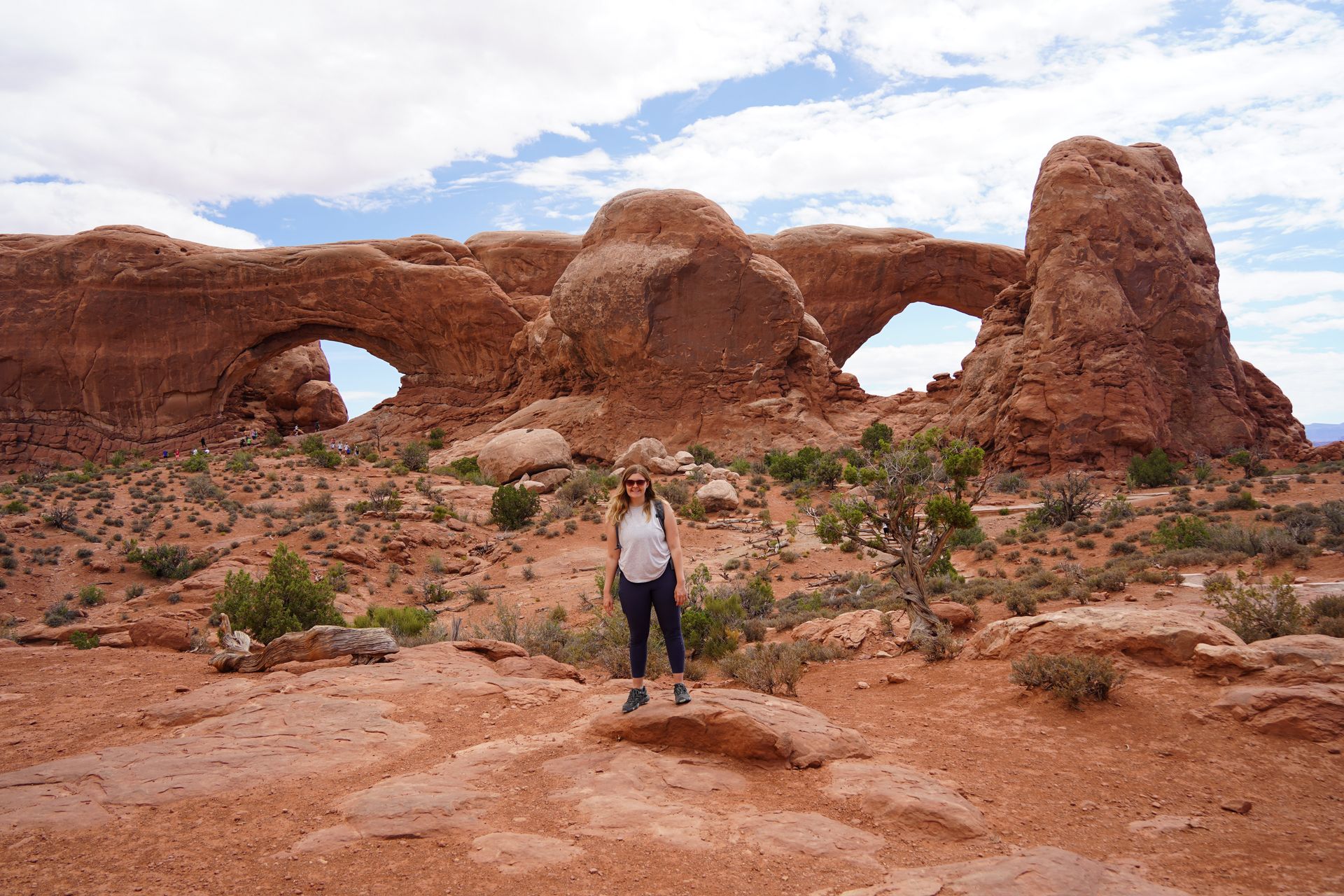
The Window and Turret Arch
From the same parking lot as Double Arch, you can take a short hike to see the Turret Arch and the Windows! Turret Arch resembles a giant turret with 2 windows in the rock next to it. The Windows refer to two huge windows in a rock that will remind you of giant eyes.
Both of these features are across from each other and can be seen from a short distance from the parking lot. If you’d like to extend your time here, there is also a primitive trail that goes behind the Windows. If you hike the primitive loop, the hike here is 1.2 miles and rated easy.
Sand Dune Arch
The Sand Dune Arch is a neat arch to visit, especially if you’re traveling with kids. The trail is less than half a mile and leads to an arch in a sand-filled canyon. It’s neat to see the sand and families love to play in the dunes.
Skyline Arch
Not far from Sand Dune Arch, Skyline Arch is another quick trail to a neat arch. The trail is less than half a mile and leads to an arch that is high up on a rock face.
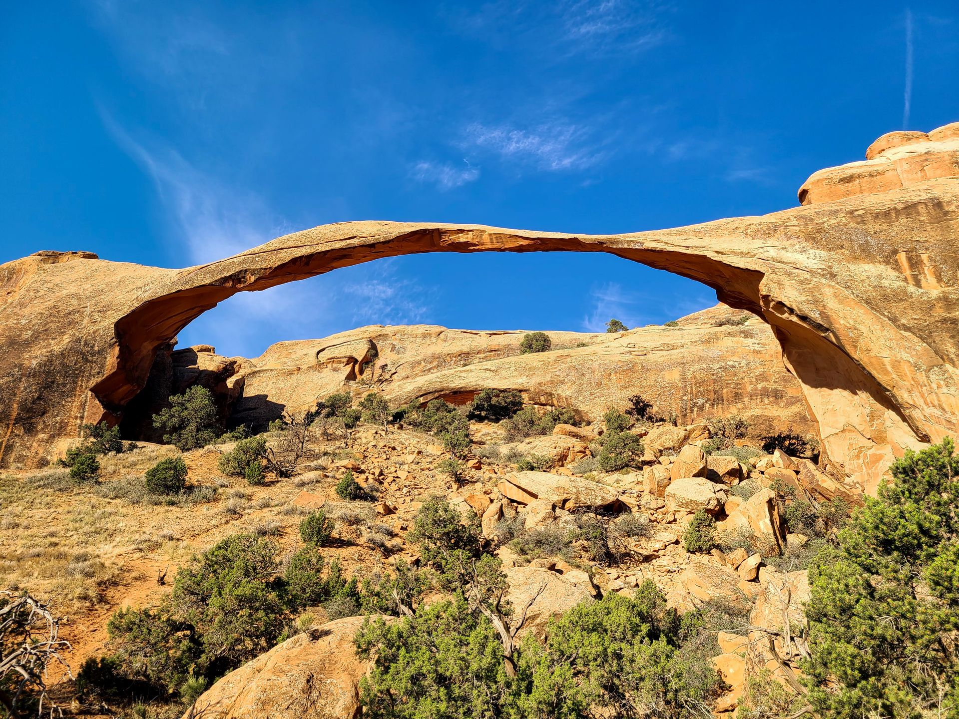
Landscape Arch
If this is your only day in the park, don’t miss Landscape Arch! This is the longest arch in North America and has an opening that is 306 feet wide! To reach it, it’s a 1.9 mile trail with minimal elevation gain. However, I recommend saving it for another day and combining it with the entire Devil’s Garden Loop, which is 7.9 miles and a more difficult trail. More on that later!
Park Avenue
If you’re not too tired, Park Avenue is a great, quick trail to add on before you leave the park. The trail is 1.8 miles out and back, rated easy and will lead you between massive rock formations that resemble the New York City skyline.
The Best Restaurants in Moab
Moab has some fantastic restaurants to enjoy after a day full of hiking. Antica Forma is the perfect place to go if you’re craving pizza. They serve a variety of wood fired pizza options along with pasta, salads, appetizers and more.
Another great choice is the Quesadilla Mobilla food truck. They serve all sorts of different quesadillas and have great vegetarian options too. The food truck is neighbors with the Moab Food Truck Park, which has many more options to choose from.
Day Three
Explore Canyonlands Island in the Sky, Dead Horse Point and take an UTV tour.
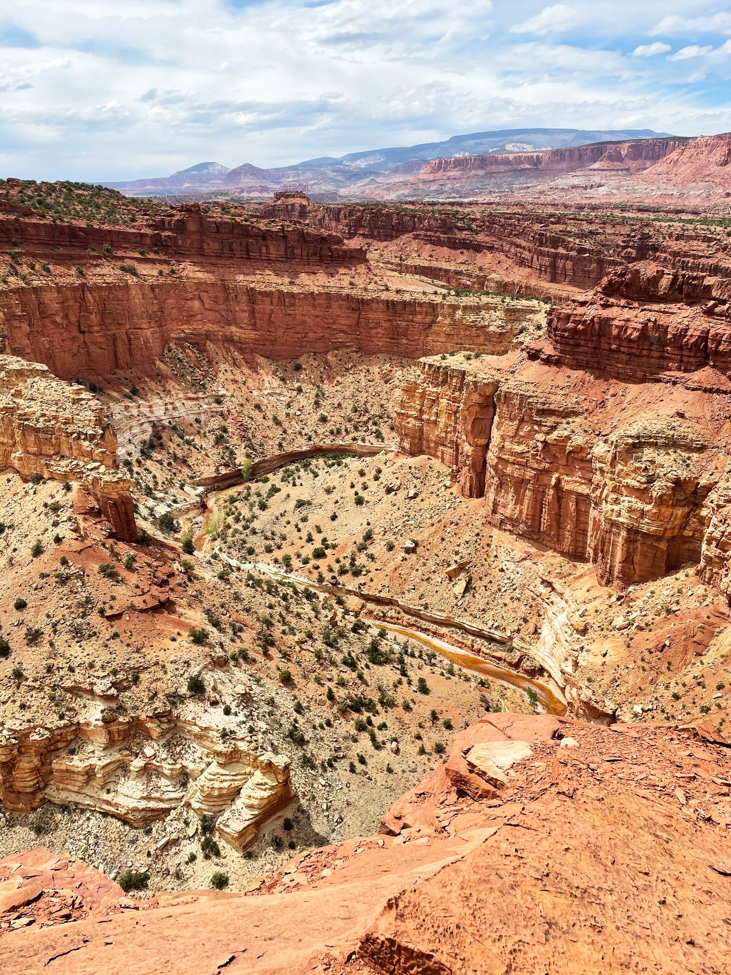
Spend your second full day in Moab exploring Canyonlands National Park! Canyonlands is made up of four distinct districts and they are a few hours apart. The most popular district is Islands of the Sky, which offers several beautiful viewpoints. If it’s your first time visiting, this is a great area to explore.
Must-See Spots in Canyonlands Islands of the Sky
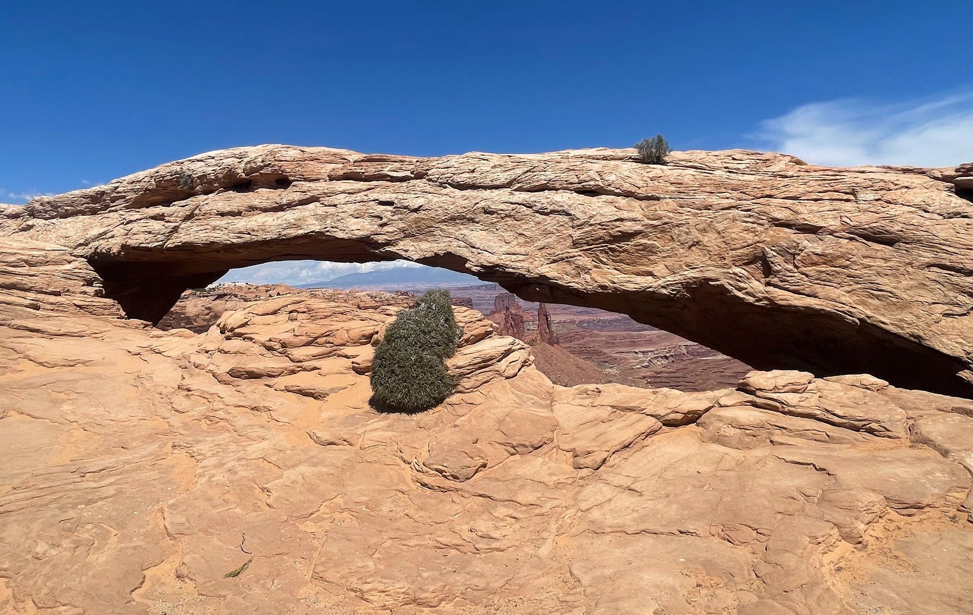
Mesa Arch
Mesa Arch is a Canyonlands must-see that is incredible at sunrise! You can watch the sun rise between the arch, making it quite a unique and beautiful sight. However, the arch is also beautiful all day if you don’t make it early enough.
To reach the arch, it’s a 0.7 mile loop trail and rated easy. It can get quite crowded, but is certainly worth seeing at least once.
Shafer Canyon
The Shafer Canyon Overlook offers a wonderful view not far from the park entrance and visitor center. Be sure to gaze down at the Shafer Canyon Trail, a rugged 4x4 road that leads to the floor of the canyon via a series of switchbacks. It’s a short walk from your car to reach the views, but be careful around steep drop offs.
Green River Overlook
The Green River Overlook offers a beautiful view of a plateau carved out by the Green River. There is white rock at the rim of the river canyon, making it a unique sight.
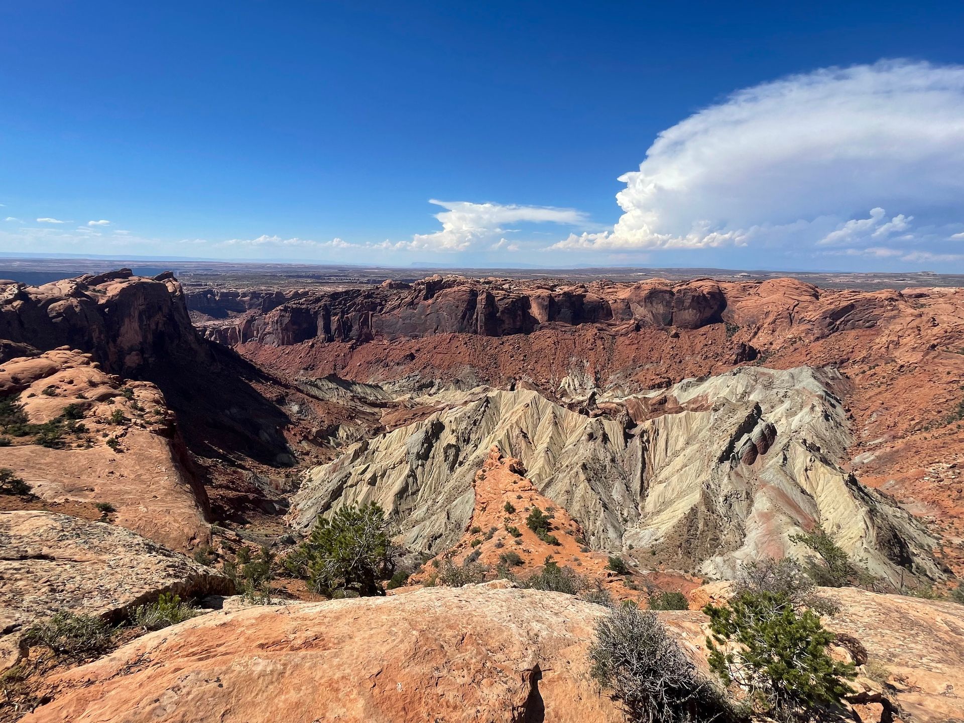
Upheaval Dome
The Upheaval Dome is located down a spur road in the Islands of the Sky District. This is another short hike that I highly recommend doing if you have time. The trail is about a half mile but includes a bit of a climb to reach the view.
The Upheaval Dome is a large crater of which no one knows for sure its cause. It was either caused by a meteor or the collapse of a salt dome. Either way, it’s a unique and fascinating place in Southern Utah!
Grandview Point
Grandview Point is the furthest you can drive in this district of Canyonlands and it offers stunning panoramic views facing south. You can take in the views from the overlook near the parking lot, or you can take a 1.8 mile hike to reach the best view.
Other Canyonlands Overlooks and Stops to Make if You Have Time
- Buck Canyon
- White Rim
- Orange Cliffs
- Aztec Butte
- Whale Rock
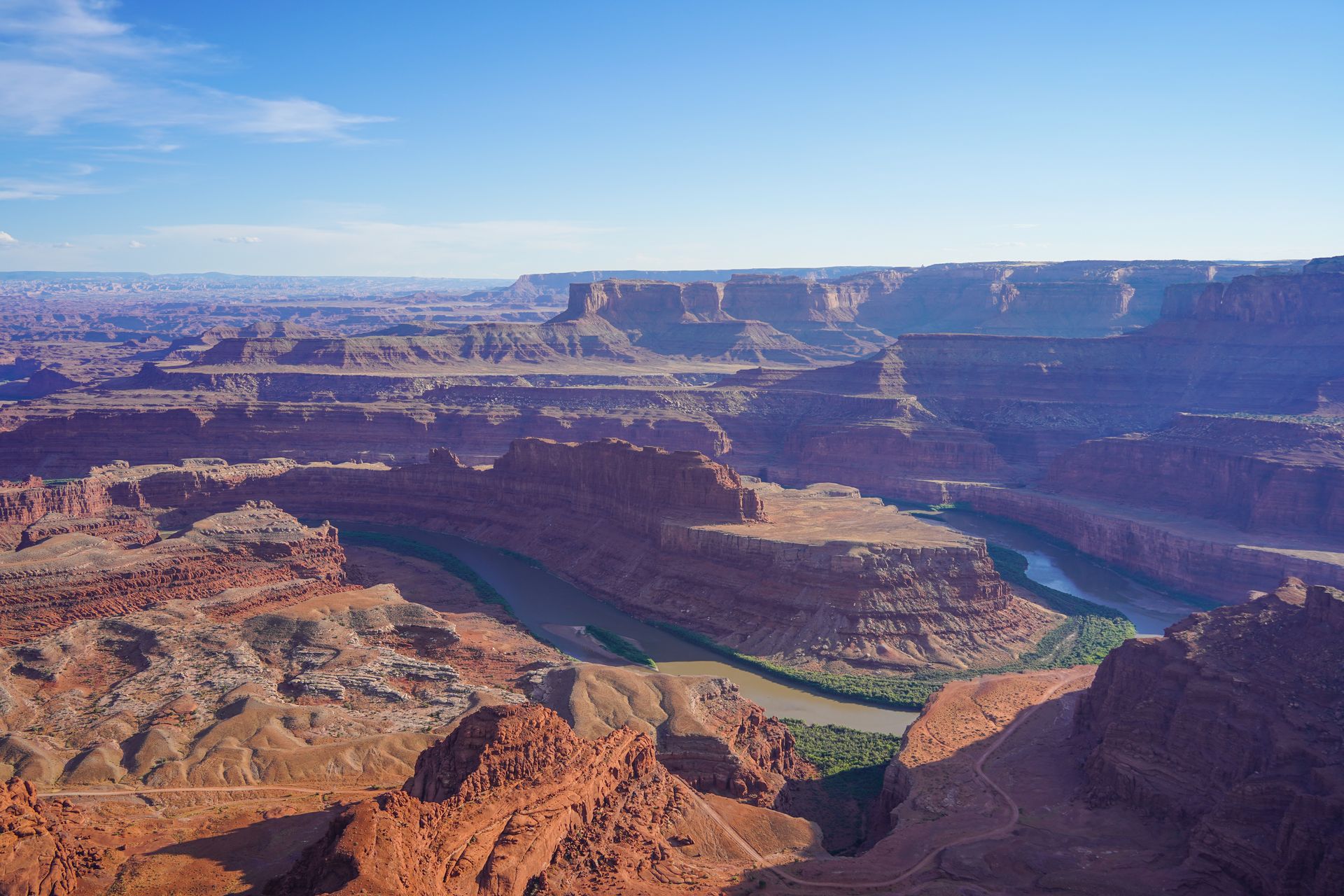
Dead Horse Point State Park
After exploring Canyonlands, it’s also worth a stop at Dead Horse Point State Park. This Utah state park is located about 20 minutes from Canyonlands and offers several beautiful views from the rim of the canyons of the Colorado River, cliffs and plateaus.
There is a 5 mile rim trail you can take to see a variety of views around the park. However, you can also just drive to one or more of the most popular areas. Dead Horse Point offers the most iconic views where you’ll get to see a dramatic bend in the Colorado River with cliffs that surround it.
If the timing works out or you’re willing to drive back, Dead Horse Point State Park also is a fantastic place to watch the sunset.
UTV Tour
If you’re up for an adventure, it’s worth taking a UTV tour in Moab! I opted for the Hell’s Revenge route with High Point Hummer. We got to drive our own UTVs while following a guide.
Hell’s Revenge involves maneuvering over large boulders and navigating next to steep drop offs. It was an exhilarating adventure that is not for the faint of heart, but is still beginner friendly!
The tour also includes views of the Colorado River, a glimpse of dinosaur tracks and plenty of neat views of the surrounding rocks. It’s an adventure that is sure to stick with you!
Day Four
Enjoy more hiking in Moab.
On your last day in Moab, spend the day hiking in either Arches or outside of the national parks. There are many trails to choose from depending on your interests.
If it’s your first time in the area, I’d recommend returning to Arches National Park to hike Devils Garden or Fiery Furnace, or both.
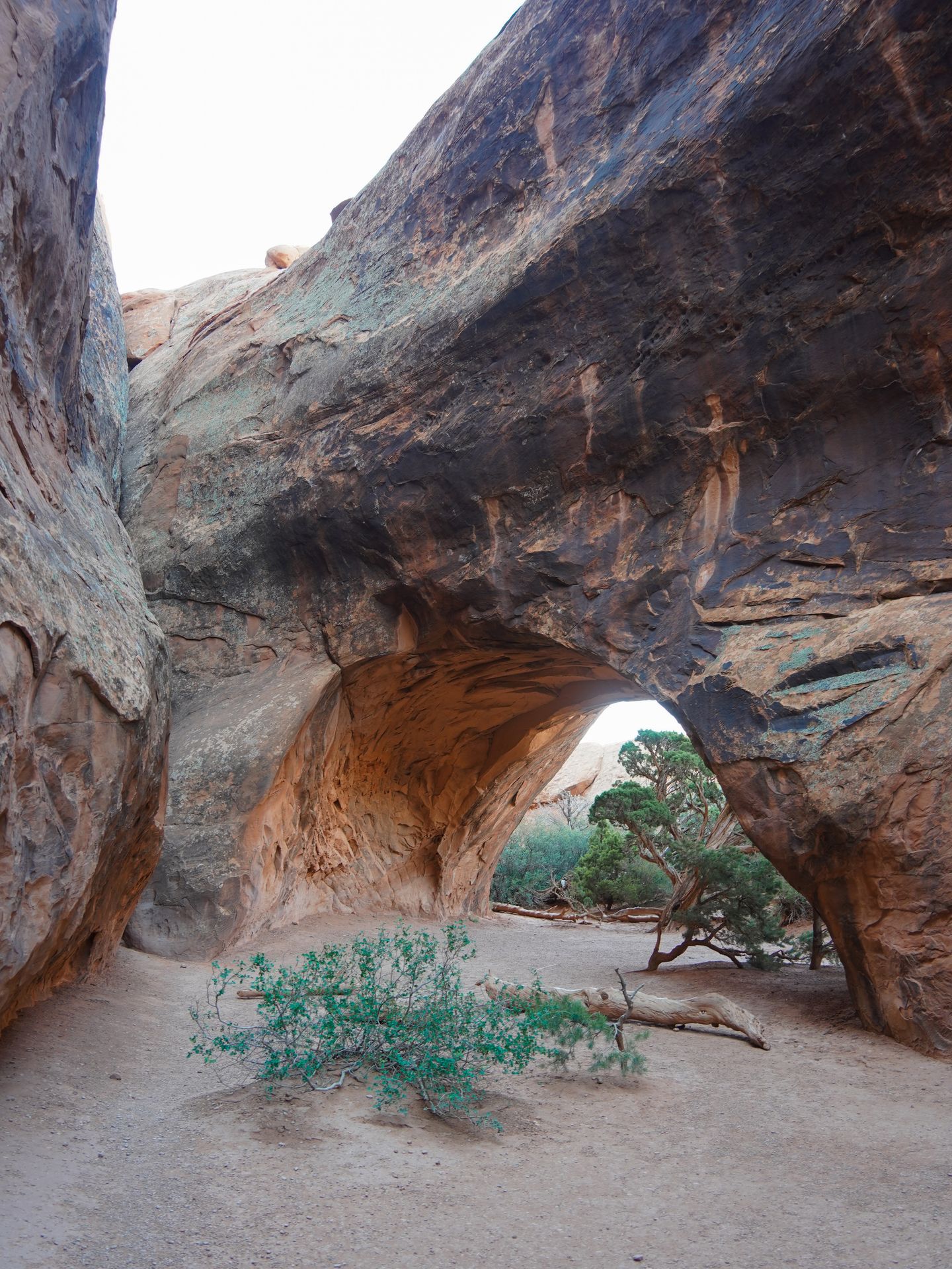
Devils Garden
Devils Garden is an 8 mile loop trail that will lead you past 7 incredible arches! The two most popular arches on this loop are the iconic Landscape Arch and the Double O Arch. If you only want to hike out and back to the Double Arch Loop, it will be 4.1 miles.
If you decide to hike the entire loop, make sure you’re prepared. The primitive trail includes some rock scrambling, hiking over sand and little shade. Some people struggle with the navigation, so make sure to download offline maps using AllTrails + and/or use a map. Also be sure to bring plenty of water, snacks and all of the hiking essentials.
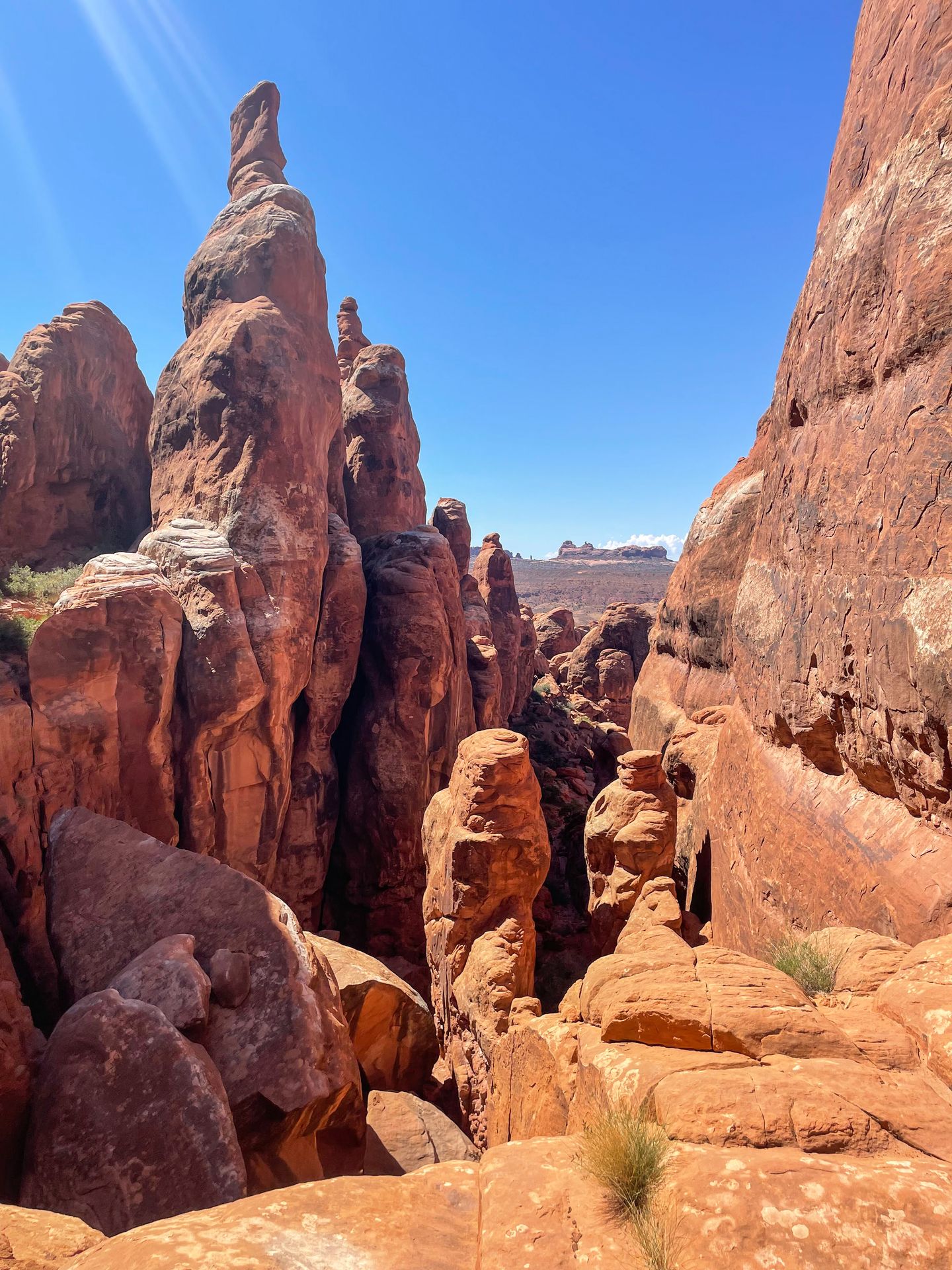
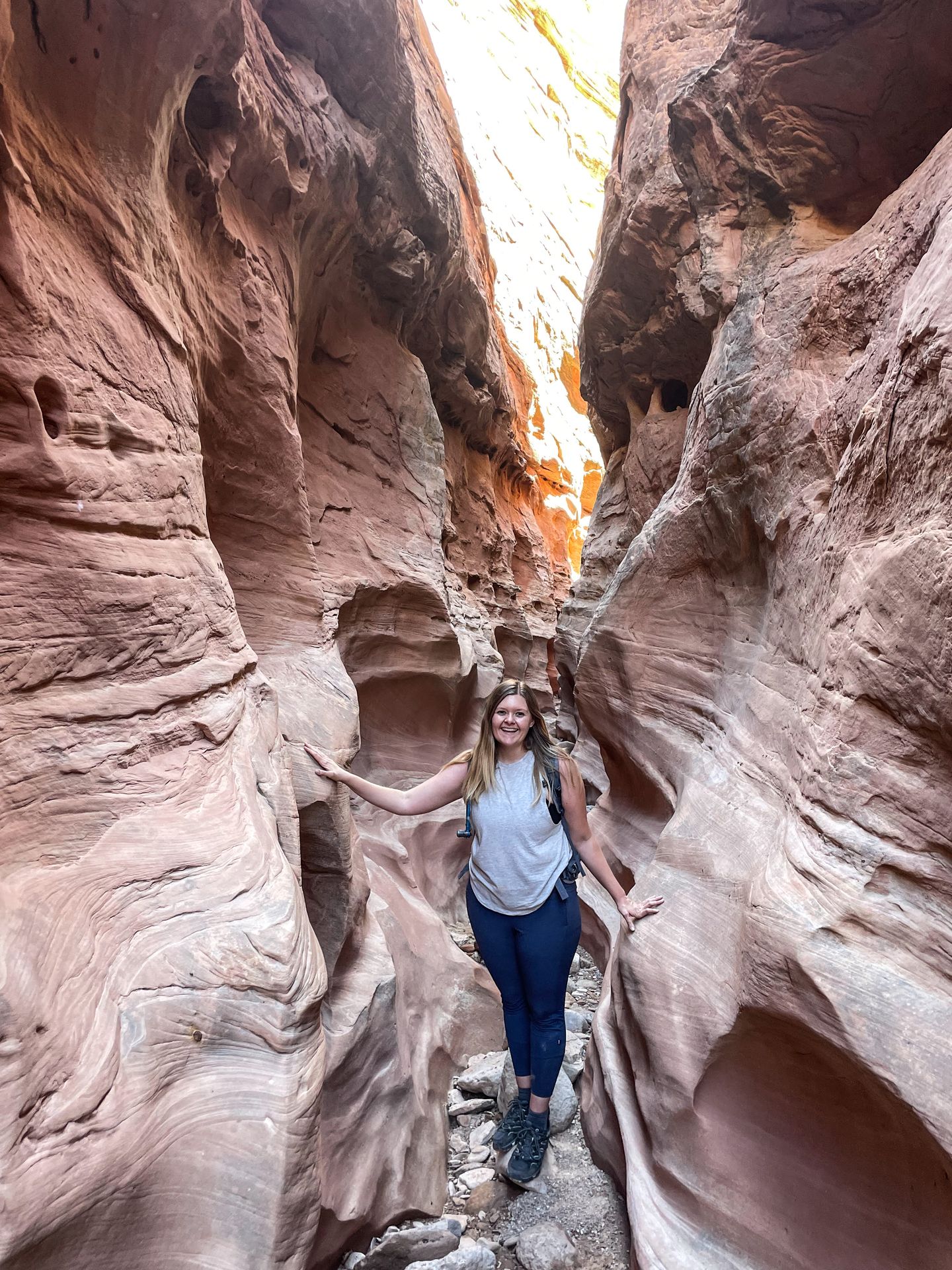
Fiery Furnace
Fiery Furnace refers to a maze of tall, orange spires and canyon walls. It’s an incredible hike if you’re able to plan ahead - this trail requires a permit. You can either snag a self-guided permit (they go on sale a week in advance) or sign up for a ranger-led tour.
If you visit self-guided, you’ll need to stop by the visitor center ahead of time to pick up your permit and attend an orientation. I would only recommend the self-guided trail for experienced hikers, because it can be tough to navigate. There is no specific trail that you must follow through the Furnace, but there is a loop that most people follow.
Going counterclockwise, there are tiny arrows that indicate the main loop. I don’t want to take away from the magic, but make sure to explore past the “dead end” signs throughout the furnace. This is where you’ll find some really neat hidden arches!
More Hiking in Moab
If you don’t want to return to Arches, there are plenty of other areas to hike and explore in Moab. One popular hike near town is Corona Arch and Bowtie Arch, which involves a 2.4 mile moderate hike.
Another great option is to head to another unit of Canyonlands. The Needles District offers some incredible hikes such as Druid Arch and Chesler Park.
There is really no shortage of adventures to be had in Moab!
Day Five
Drive from Moab to Capitol Reef with stops along the way.
Take your time driving from Moab to Capitol Reef with some spots along the way! Without stops, the drive should take a little over 2 hours.
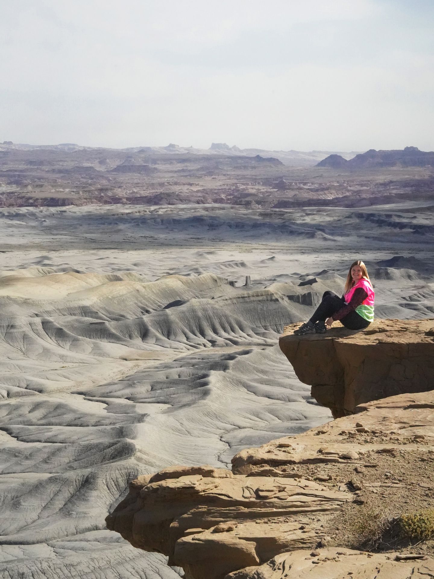
Goblin Valley State Park
If you have time, I highly recommend a stop in Goblin Valley State Park.
When you reach Goblin Valley State Park, make sure to visit the iconic Valley of the Goblins. You can freely explore this area and walk around the iconic orange hoodoos that make the park so famous.
Other popular trails in the park include the hike to the Goblin's Lair, the hike to Little Wild Horse Canyon and the hike to Wild Horse Window.
Little Wild Horse Canyon is a slot canyon, so it is very important to avoid it if there is any chance of rain (flash flooding is very dangerous). Wild Horse Window is not well marked, so make sure to download offline maps ahead of time and come prepared.
Hanksville
If you’re up for another detour before reaching Capitol Reef, it’s worth a stop in the Hanksville Area. One really neat place to visit is the Moonscape Overlook. Keep in mind that the road to reach this spot is unpaved and should not be attempted while wet. While any vehicle can probably make it to this point, it’s best to have 4x4 and decently high clearance.
This spot is especially beautiful at sunset!
If you decide to skip Hanksville, there are also some beautiful places to watch the sunset in Capitol Reef. I recommend Sunset Point, Goosenecks Overlook or Panorama Point.
Where to Stay Near Capitol Reef
Hotels near Capitol Reef
There are a few different hotels outside of Capitol Reef, but you’ll have less options than Moab. One place I loved staying was the Rim Rock Inn, which is right next to the park and has some gorgeous views from their patio restaurant next door.
Other nearby hotels include the Capitol Reef Resort, Red Sands Hotel and Skyridge Inn Bed & Breakfast.
Camping in Capitol Reef
Capitol Reef offers 71 reservable campsites at Fruita Campground inside the park. Reservations are available from March 1 to October 31 and fill up quickly. Make sure to book early!
Day Six
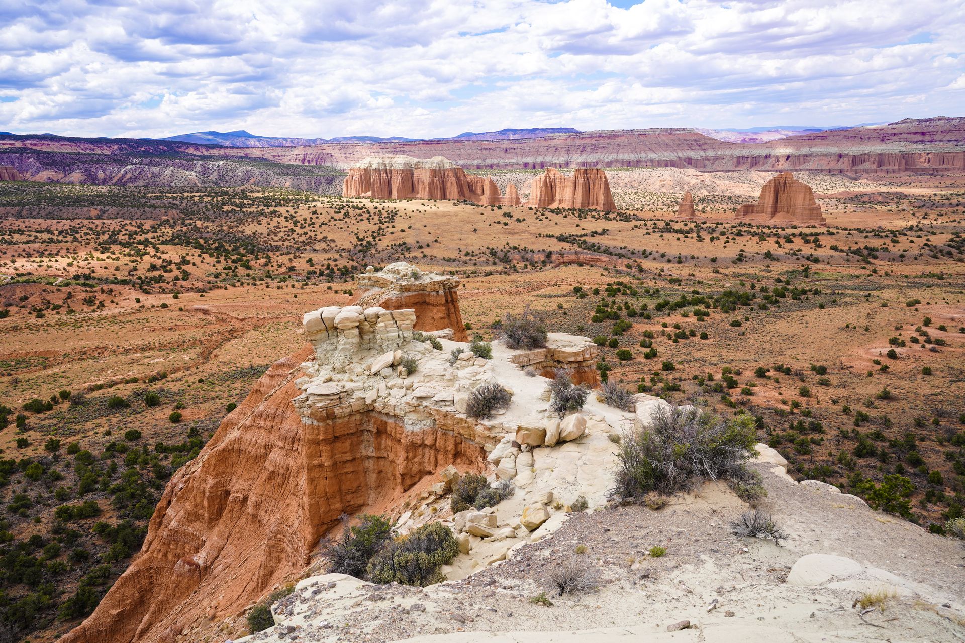
Explore Capitol Reef National Park.
The Best Things To Do in Capitol Reef National Park
Spend this day exploring all of the main highlights of Capitol Reef National Park! If you have a 4x4 vehicle (or rent one), I’ve listed some additional areas to explore at the bottom.
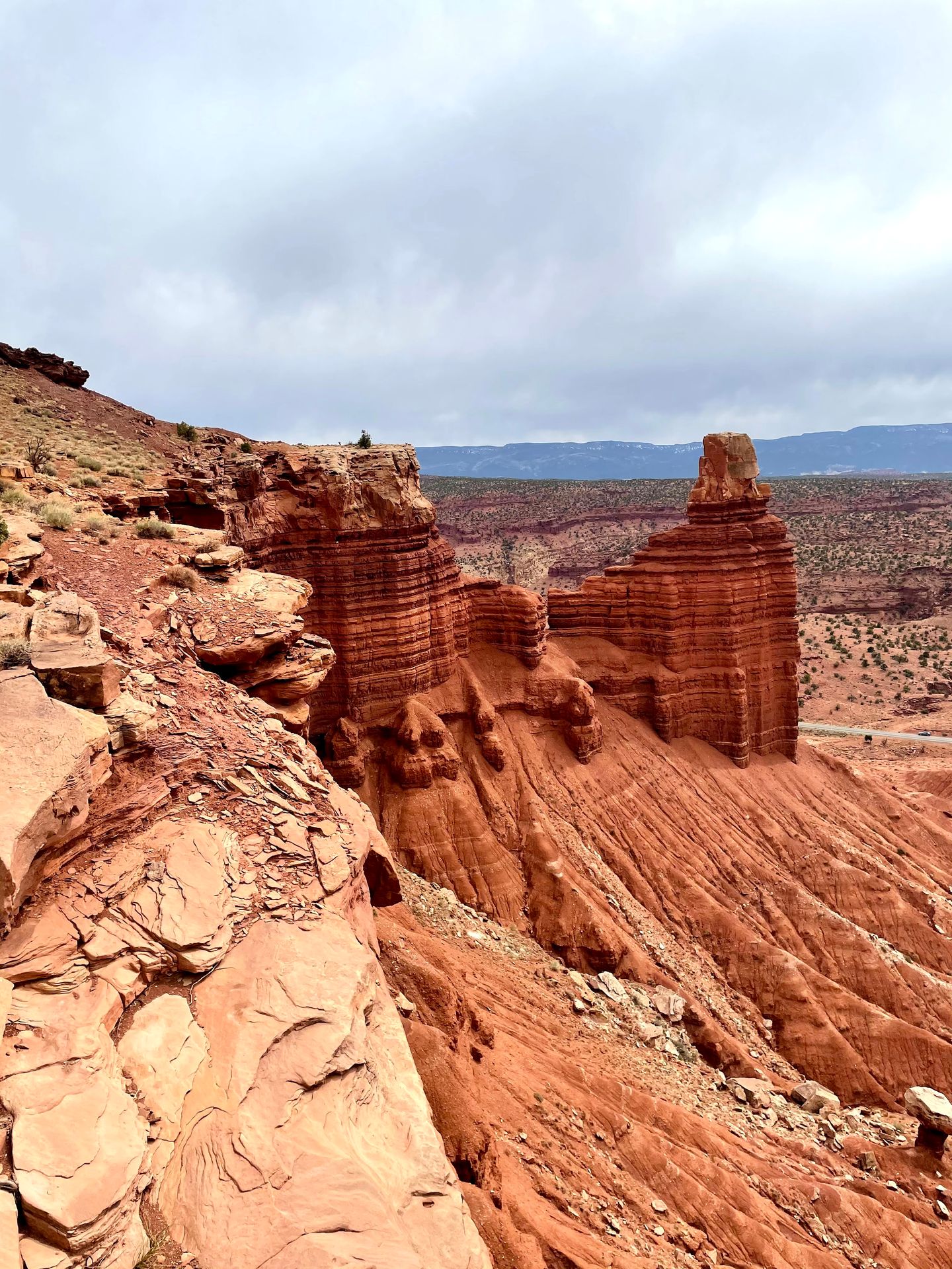
Cassidy Arch
Cassidy Arch is an iconic trail in Capitol Reef that offers sweeping views of a giant arch and the surrounding orange-rock landscape. The trail to Cassidy Arch is 3.1 miles with 665 feet of elevation gain. The hike includes some drop offs and slick rock areas, so be sure to keep an eye on children.
When you reach the top, you can admire the arch, walk across it and you may even see people rappelling down from the arch!
Pie from Gifford House
Capitol Reef is known for its famous fruit pie and there are even fruit orchards growing inside the park! It’s a must to get one of their mini pies during your visit. But don’t wait until the end of the day, as they often sell out in the middle of the day. Flavors include mixed berry, strawberry-rhubarb, cherry and more. I don’t think you can go wrong!
In addition to pie, the Gifford House has a historic museum area and sells other items such as salsa, jams, books and more.
Take a Scenic Drive
The Capitol Gorge Road in the park offers stunning views and is a little under 5 miles. There are viewpoints along the way and rocks with stunning stripes of yellow, pink, orange and red. It’s a quick drive that is definitely worth spending some time exploring. After 5 miles, the road becomes unpaved and you can continue if you have the right car and enough time!
See the Petroglyphs
It’s worth a quick stop at the Petroglyph Panel, located near the Fruita Schoolhouse on Utah Route 24. You’ll take a short boardwalk to get up close to petroglyphs left by ancestors of the Hopi Tribe, Pueblo of Zuni and Paiute Tribe. The petroglyphs were created sometime between 300 and 1300 Common Era.
Hike Chimney Rock or Hickman Bridge
The Chimney Rock Trail is a relatively short but highly rewarding trail located near the entrance to the park. This 3.3 mile loop trail has 793 feet of elevation gain and likely will be less crowded than other popular trails.
If you take the trail counter-clockwise, you will climb the elevation at the beginning and then gradually descend the rest of the trail.
The entire trail has beautiful views, but its most notable feature is a great view of Chimney Rock - a 6,420 foot tall rock resembling a chimney. The chimney was interesting, but I was honestly even more blown away by the aerial views this hike provides. You essentially are walking along the rim of a tall rockface and can see for miles.
For a shorter hike, the Hickman Bridge Trail is another popular and family-friendly option! It is 1.7 miles with 416 feet elevation gain and leads to a large natural bridge. Or if you have enough time, do both hikes!
Scenic Overlooks
Before you leave the park, be sure to take in the views from Panorama Point and the Goosenecks Overlook. Both of these viewpoints are close to the entry of the park.
Panorama Point is located right off the main road and is a quick walk away from the parking area. It’s an amazing place to watch the sunset inside Capitol Reef.
Goosenecks Overlook is located a little less than a mile down an unpaved road from Panorama Point. For being so close, this view offers a totally different experience. Take the short half mile hike and you will arrive at a viewpoint overlooking a large S-shaped curve in the Sulphur Creek. The creek has carved a deep gorge creating a unique and gorgeous sight to see.
If you have a 4x4 Vehicle and More Time
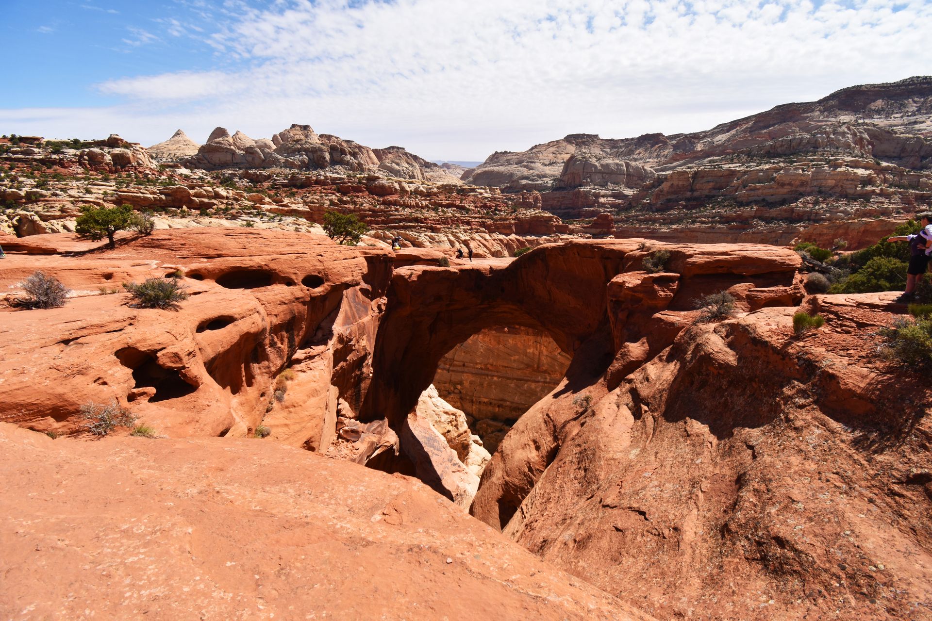
Most people only do some of the activities I’ve listed above. There is nothing wrong with that, but Capitol Reef offers MUCH more to explore if you have a 4x4 vehicle and high clearance. One option is driving the Cathedral Valley Loop, a 57.6 mile drive that requires a riving crossing (water levels vary). The drive leads past many incredible sights, from towering rock formations to unique geology. It’s an incredible adventure, but a remote area. You’ll need to make sure you’re prepared to self-rescue.
Another option is to drive the Loop the Fold, a 124-loop in the Southern part of the park. It generally takes 4-6 hours but can easily take a full day with all of the various trail options! Most cars can navigate this drive, but it depends on weather conditions. And some spur roads off of the main road require 4x4 and high clearance.
Personally, I think that Capitol Reef is the most underrated Utah national park and is a great place to add more time if you’re up for an adventure!
Day Seven
Drive from Capitol Reef to Bryce Canyon.
Make the drive from Capitol Reef to Bryce Canyon, which takes about 2 hours on its own.
However, you’ll pass through Grand Staircase-Escalante and have a great opportunity to hike to a waterfall. Lower Calf Creek Falls is a 6.1 mile trail that leads to a stunning 130-foot waterfall.
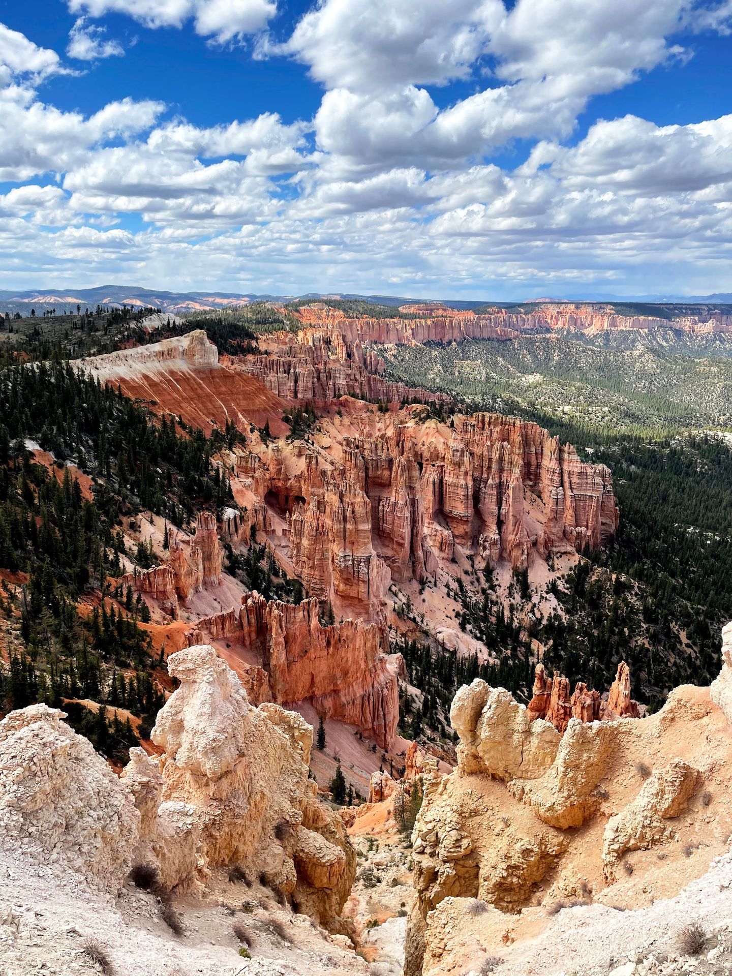
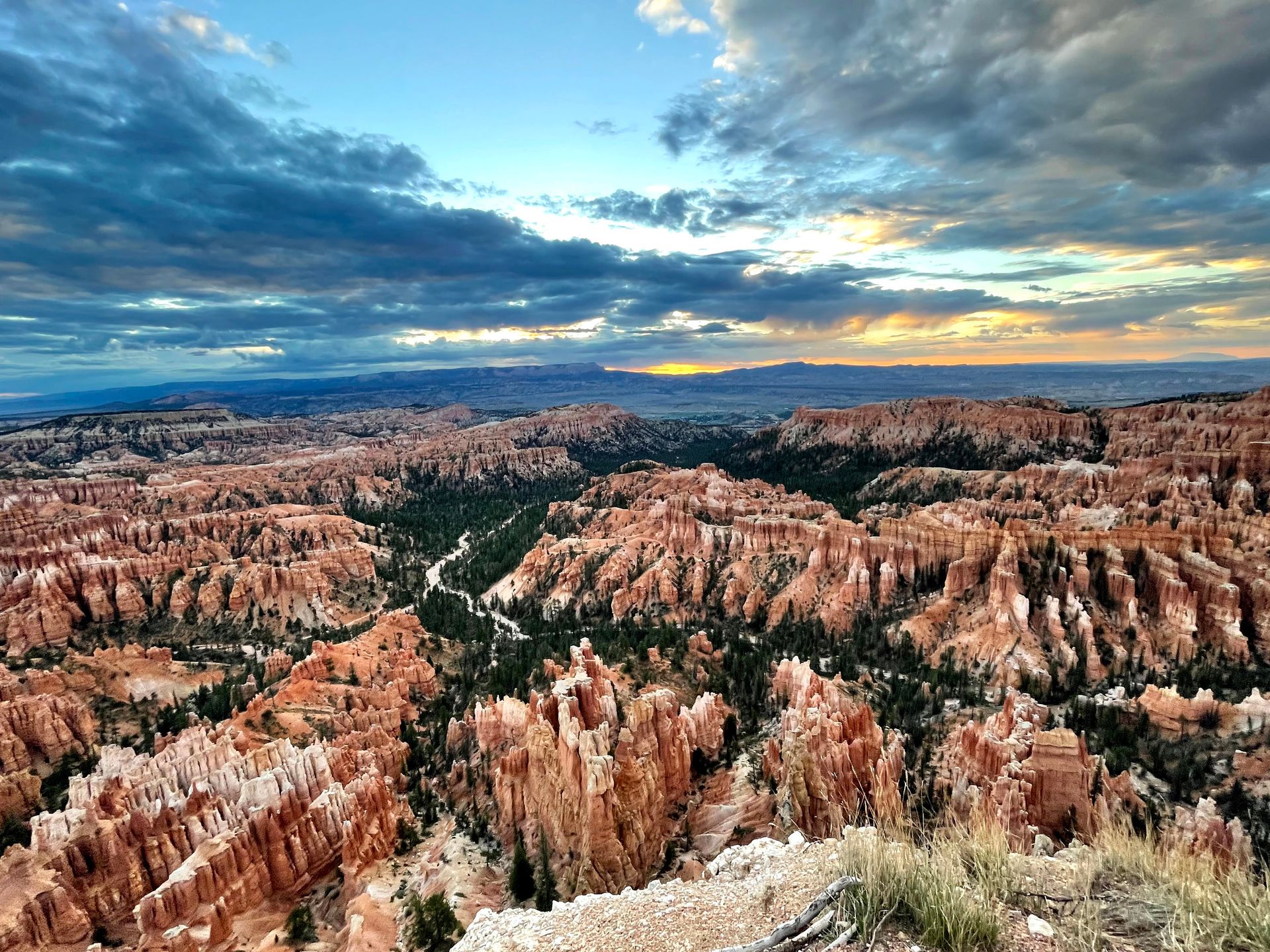
Take the Bryce Scenic Drive
Depending on when you arrive in Bryce and how tired you are, you may have time to hike as well. But if you’re ready for a break from your feet, there is a beautiful scenic drive you can do to see some of the park.
The Scenic drive is 17 miles and takes about 30 minutes each way. There are a few viewpoints along the way, including Rainbow Point and Natural Bridge.
I recommend sticking with the main Amphitheater section of the park for sunset. There are a few iconic viewpoints including Inspiration Point, Bryce Point, Sunset Point and Sunrise Point. They all offer incredible views of the Hoodoos!
Where to Stay Near Bryce
Hotels near Bryce
There are a couple hotels right outside of Bryce, the most popular being the Best Western Plus Ruby Inn.
Camping in Bryce
Bryce Canyon National Park offers two campgrounds with about 100 sites. The campsites require a reservation during peak season (May to October) but are first-come, first-serve during the off season.
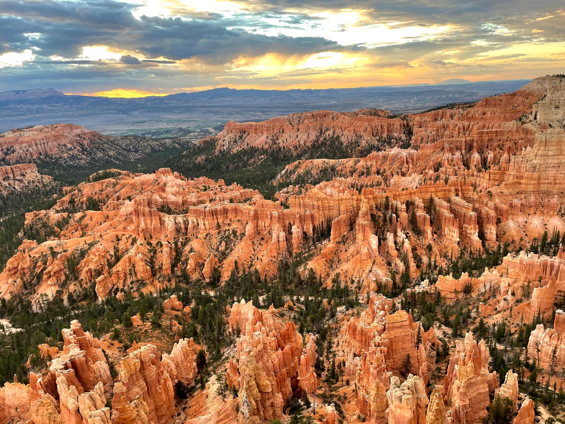
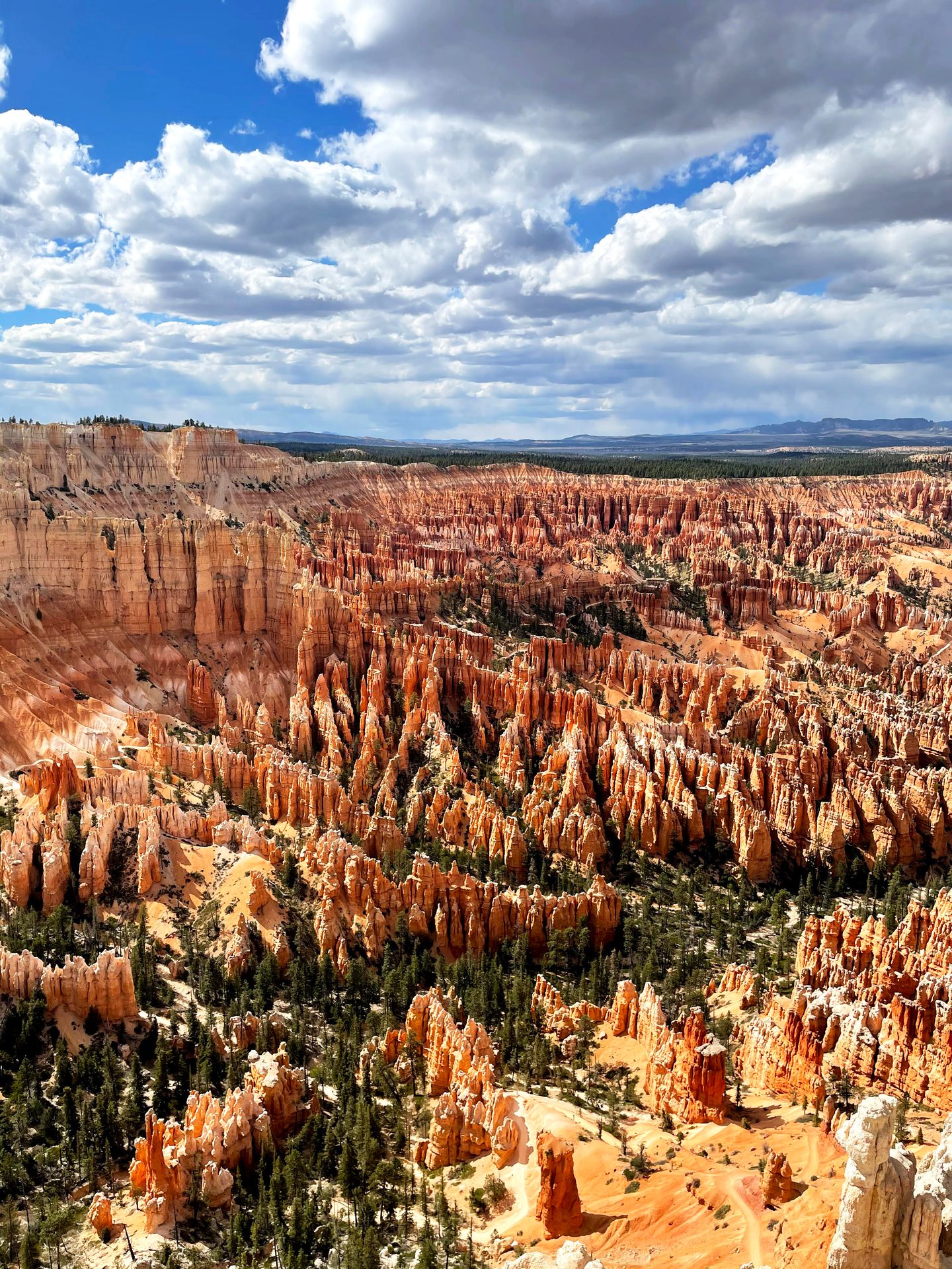
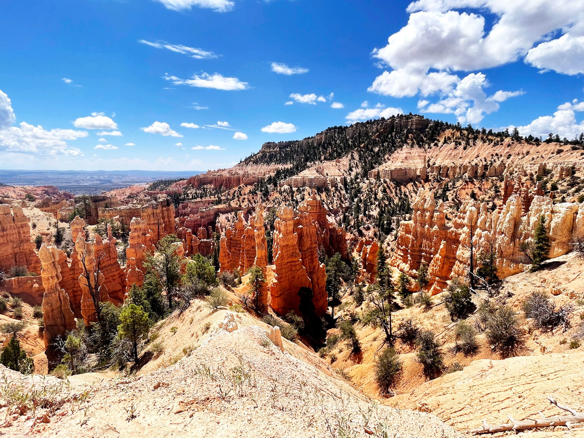
Day Eight
Hike in Bryce Canyon.
The Best Hiking in Bryce Canyon
Spend this day exploring some of the best things that Bryce has to offer!
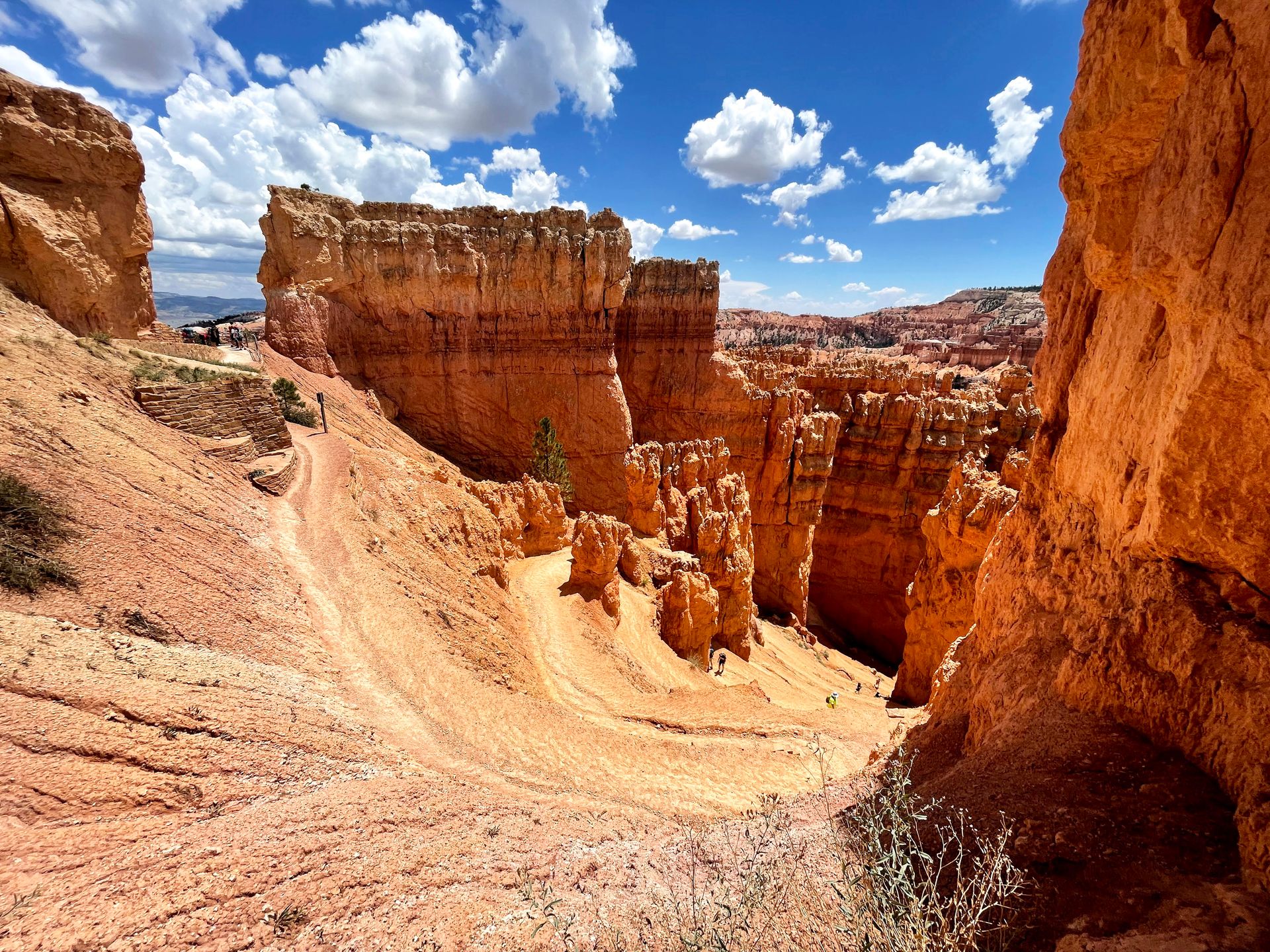
One trail that you can’t miss in Bryce Canyon (if you’re a hiker) is the Queen’s Garden and Navajo Loop. This hike will lead you down into the canyon where you can walk among the hoodoos.
I recommend starting at Sunset Point and hiking down the iconic Wall Street, which is an experience in itself. Iconic switchbacks descend down into the canyon steeply and the rocks become more narrow as you climb down. After you conquer Wall Street, the trail levels out on the canyon floor and you will begin to see trees scattered around the hoodoos.
You can complete the loop by adding on Queen’s Garden. On the Queen’s Garden trail, you’ll get to see rock formations that resemble Queen Victoria, the head of ET and more. The Navajo Loop and Queen’s Garden’s trails combined are 3.1 miles with 649 feet of elevation gain.
If you’re up for it, I highly recommend adding on the Peekaboo Loop trail to your hike. The Peekaboo Loop includes mini rock tunnels and more elevation change as you make your way up and down. It was my favorite trail in Bryce Canyon!
If you connect the Peekaboo Loop with the Queen’s Garden and Navajo trails, the hike is 6.3 miles, has 1,499 feet of elevation gain and is known as the ‘Figure Eight Trail.’
Other Things To Do in Bryce Canyon
Fairyland Loop
If you’re looking for a less-crowded, but still beautiful, trail in Bryce Canyon, I recommend the Fairyland Loop!
The Fairyland Loop has the youngest hoodoos in the park and offers spectacular views throughout the 8 mile journey. This trail is a bit more difficult than the Peekaboo Loop as it is longer and has more elevation.
Along the way, you’ll see Tower Bridge, the China Wall and get to take in a variety of scenery.
Mossy Cave
If you’re looking for a short and kid-friendly hike, check out Mossy Cave. The hike is just under a mile and includes a waterfall and a neat area with window rock formations. It is located just outside the main area of the park.
Horse-Back Riding
Horseback riding is a popular way to see the canyon from a different perspective. There are 2-hour and 3-hour guided rides offered by Canyon Rides, and tours take place between April and October.
Day Nine
Drive from Bryce to Zion and begin exploring Zion.
Drive from Bryce Canyon to Zion National Park, which should take about 2 hours. Potential stops along the way include Red Canyon or the Belly of the Dragon near Mt Carmel Junction.
When you arrive in Zion, there are many trails to choose from!
Quick Trails in Zion National Park
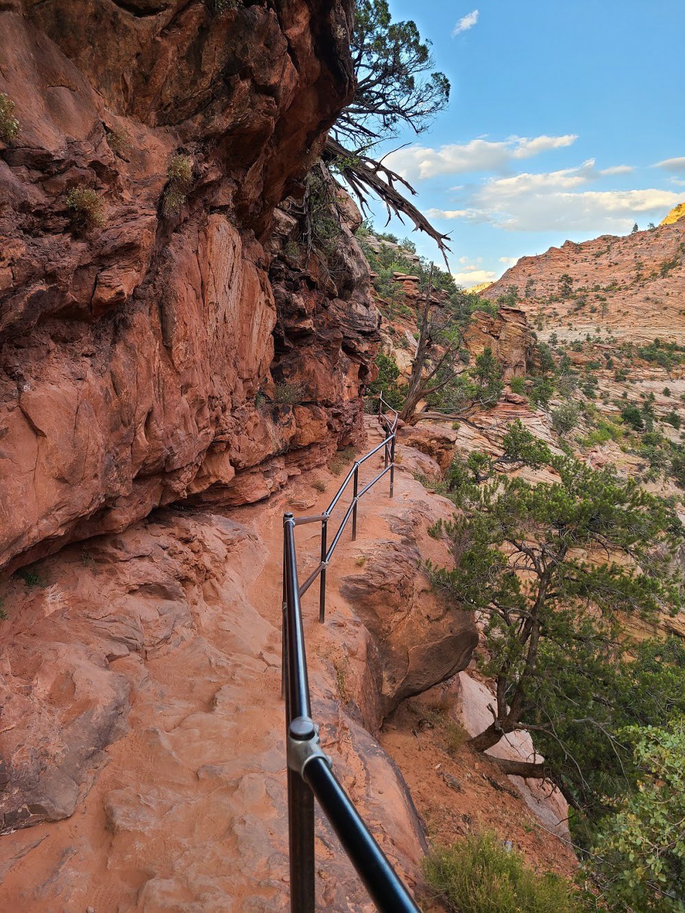
Canyon Overlook
One hike that is a great easy option is the Canyon Overlook Trail. This trail is 1 mile round trip and offers amazing canyon views. There are many instances of steep drop offs, but also railings placed throughout the trail. The final overlook provides an excellent viewpoint into Zion Canyon and is right above the Great Arch.
Emerald Pools
The Emerald Pools trail lead to some beautiful seasonal waterfalls. There are a few different trails in this area, including the Lower, Middle and Upper Emerald Pools trails. To combine all of the trails, it's 3 miles round trip.
Where to Stay Near Zion
Hotels near Zion
The town of Springdale is located right outside of Zion National Park and has several hotels to choose from. Depending on where you stay, you can take a shuttle or even walk to the park.
I had a great experience staying at the La Quinta in Springdale. Other great hotels to choose from include the Holiday Inn Express, Bumbleberry Inn and the Driftwood Lodge.
Camping in Zion
Zion National Park offers 3 different campgrounds. The Watchman Campground is open year round and reservations can be made up to six months ahead of time.
The South Campground is only partially open as of this writing due to renovations. Reservations can be made up to two weeks ahead of time.
If you’re willing to drive a bit further, the Lava Point Campground is located about an hour from Zion Canyon (the main area of the park).
Day Ten
Hike in Zion National Park.
The Best Day Hikes in Zion - Angel’s Landing and the Narrows
Spend the day hiking one or both of the most famous trails in Zion - The Narrows and Angel’s Landing. These are a couple of the best things to do in Zion if you only have a couple days.
The Narrows
If it’s your first time visiting Zion, it’s certainly worth hiking one of the most iconic trails!
The Narrows is a unique hike through the North Fork Virgin River with canyon walls towering above. You’ll need to be prepared to get your feet wet (and potentially go up to waist deep).
If you want to hike the Narrows, make sure to check for any chance of flash flooding ahead of time. You’ll also want to come prepared with hiking poles and shoes that you don’t mind getting wet. There are options to rent gear outside the park if you need!
The hike to the narrows begins on the Riverside Walk. You will hike for about 1 mile before you reach the point where you enter the water.
The Narrows are out-and-back, so you can hike as far as you would like. I recommend trying to make it to ‘Wall Street’ to see monumental canyon walls towering up around you. In this area, the walls are 1500 feet tall while the river is only 22 feet wide.
Allow plenty of time and expect it to take longer than normal to walk through the water. Also keep in mind that the crowds will thin out a lot the further you go.
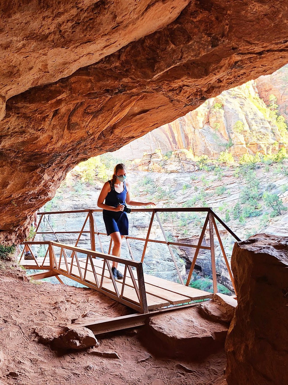
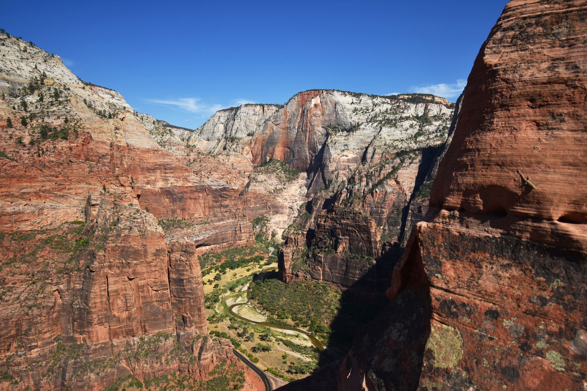
Angels Landing
Angels Landing is another epic and iconic trail in the park! But it requires preparation - a permit is required to hike the trail. Permits can be obtained via a seasonal lottery and a lottery the day before. Check recreation.gov to find what date you’ll need to enter the lottery!
The hike to Angel’s Landing involves a steep climb up many switchbacks and then a chain section with steep drop offs on both sides. I recommend opting out of the chain portion if you’re afraid of heights!
From the top of the trail, you’ll get to enjoy expansive views of the Zion Canyon down below. It’s truly incredible.
Day Eleven
Drive from Zion to Salt Lake City with stops along the way.
On your final day, drive back to Salt Lake City to catch your flight. The drive between Zion and Salt Lake City takes about 4 hours without stops.
Stops Between Zion and Salt Lake City
Along the way, a couple places you could stop include the Kolob Canyons portion of Zion National Park and Kanarra Falls.
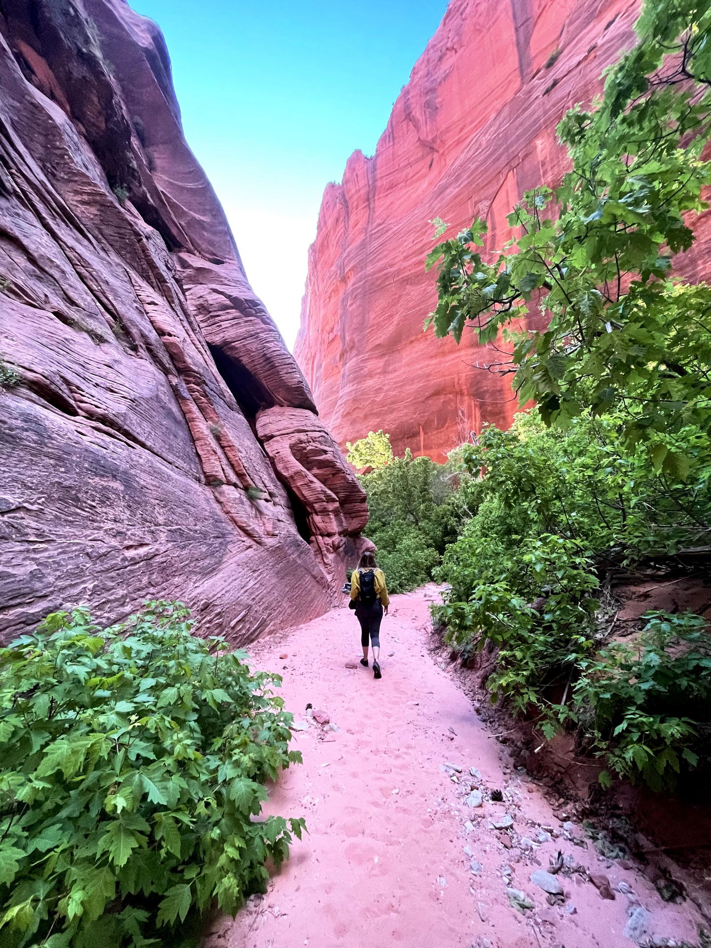
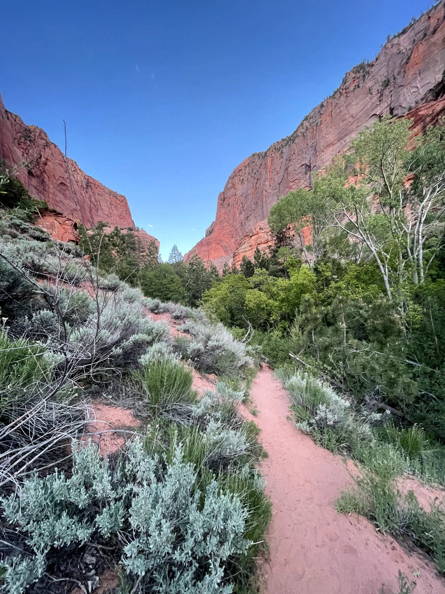
Kolob Canyons
The Kolob Canyon portion of Zion offers more stunning views with much fewer crowds. There is a gorgeous scenic drive that includes multiple overlooks where you can admire the canyons, cliffs and peaks.
One trail I absolutely loved was the South Fork Taylor Creek trail. The trail has gorgeous pink sand and leads to a canyon with towering walls.
Kanarra Falls
Kanarra Falls is similar to the Narrows in that you’ll be hiking in water. But for this trail, you’ll be climbing ladders next to waterfalls!
A permit is required for this trail with the limit of 150 visitors per day. The hike is 4 miles and you should allow 3-4 hours.
Day Twelve
Fly out of Salt Lake City!
If you have time before your flight, here are a few things to do nearby. Salt Lake City offers a ton of outdoor recreation that is completely different from the southern Utah national parks and is worth a trip in itself!
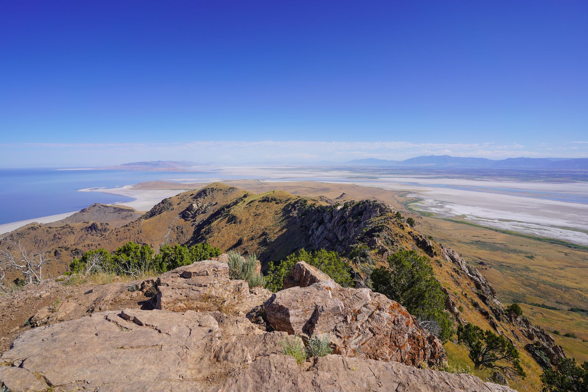
Activities in Salt Lake City include hiking and exploring Antelope Island State Park, taking the short trail to the top of Ensign Peak for views of the city and trying an iconic ‘dirty soda’ from Thirst or Swig.
Final Thoughts
I hope this guide helps you plan an epic Utah road trip that is full of adventure, hiking and incredible views. After almost 2 weeks exploring the Utah national parks, you’re sure to be tired but full of appreciation for this incredibly beautiful state.
For more information on visiting Utah, check out some of my other travel guides:
- Things to do in Kanab, Utah
- Two Days in Zion National Park
- The Top Things to do in Bryce Canyon
- How to Spend One Day in Capitol Reef National Park
- 11 Amazing Trails Near Salt Lake City
- How to Spend a Weekend in Salt Lake City
Thanks for Reading!


Let's stay in touch!
Join the Lost with Lydia email list to get monthly travel guides and tips!